1940s Maps of Lea County, New Mexico
Explore 2 historic maps of Lea County from the 1940s. These maps offer a rare glimpse into what life looked like during the 1940s — showing old roads, neighborhoods, homes, and landmarks that have changed or disappeared over time.
Whether you're researching your family's past, planning a metal detecting trip, or studying how Lea County's landscape evolved across the 1940s, these high-resolution maps are a powerful tool for exploring the history of this region.
- Focus on a specific era: All maps on this page are from the 1940s, giving you a focused view of this time period.
- See what’s changed: Compare century-old streets, trails, and buildings to today's modern landscape using overlays and satellite layers.
- Research with precision: Use these maps for genealogy, historical research, land use analysis, or educational projects.
- View, download, or print: Maps are fully viewable online in high resolution, and can be downloaded or printed for your own records.
Start exploring Lea County's history through authentic maps from the 1940s. This is your window into the past.
Lea County, NM maps
(2)- 1942 Map of Clayton Basin, 1958 Print
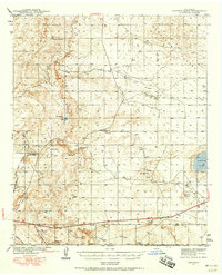 1942 Clayton Basin1958 Print · USGSSoutheastern New Mexico's potash and ranching country comes to life in the years surrounding World War II. Researchers can locate family outposts like Lusk Ranch and Wood Ranch or trace the early industrial footprint of the Potash Co of America Mine.2 unique versions available
 - 1943 Map of Clayton Basin
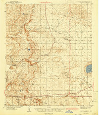 1943 Clayton Basin1943 Print · USGSEddy and Lea Counties are mapped here during the early 1940s as the potash industry and ranching shaped the high desert landscape. Genealogists and historians can locate old cattle headquarters like Lusk Ranch and trace the spur of the Santa Fe Railroad (Oil City).2 unique versions available
End of results
Showing maps 1-2 of 2
Top cities of Lea County
- Hobbs historical maps
- Lovington historical maps
- Eunice historical maps
- Jal historical maps
- Tatum historical maps
Frequently asked questions
- What are the different types of historical maps available for Lea County?
- What is the oldest map of Lea County?
- Where can I purchase historical maps of Lea County for my home or office?
- Where can I download high-res historical maps of Lea County?
- Are there historical topographic maps available for Lea County?
- Is there historical aerial imagery available for Lea County?
- Where are historical maps of Lea County sourced from?