1900s (20th Century) Maps of Oil Center, New Mexico
Explore 5 historic maps of Oil Center from the 1900s (20th Century). These maps offer a rare glimpse into what life looked like during the 1900s — showing old roads, neighborhoods, homes, and landmarks that have changed or disappeared over time.
Whether you're researching your family's past, planning a metal detecting trip, or studying how Oil Center's landscape evolved across the 1900s, these high-resolution maps are a powerful tool for exploring the history of this region.
- Focus on a specific era: All maps on this page are from the 1900s, giving you a focused view of this time period.
- See what’s changed: Compare century-old streets, trails, and buildings to today's modern landscape using overlays and satellite layers.
- Research with precision: Use these maps for genealogy, historical research, land use analysis, or educational projects.
- View, download, or print: Maps are fully viewable online in high resolution, and can be downloaded or printed for your own records.
Start exploring Oil Center's history through authentic maps from the 1900s. This is your window into the past.
Oil Center, NM maps
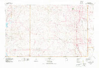
(5)- 1954 Map of Hobbs, 1963 Print
 1954 Hobbs1963 Print · USGSThe High Plains and Permian Basin transition is captured here at the height of the mid-century energy boom. Genealogists and industrial historians can trace the foundations of Humble City, locate the Potash Mine and Plant, and follow the Texas-New Mexico RR.2 unique versions available
 - 1958 Map of Hobbs
 1958 Hobbs1958 Print · USGSThe High Plains of the Texas-New Mexico border are shown here during the height of the mid-century oil boom. Genealogists and historians can trace the development of Hobbs, Lovington, and Jal, alongside ranching landmarks like James Ranch and the early Texas-New Mexico Railway.
 - 1963 Map of Oil Center, 1964 Print
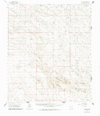 1963 Oil Center1964 Print · USGSLea County in the early sixties was a landscape defined by the growing petroleum industry and the essential search for water. Researchers can trace the mid-century infrastructure of the Monument Jal Oil Field and locate isolated landmarks like San Simon Ranch and San Simon Sink.2 unique versions available
 - 1978 Map of Jal, 1979 Print
 1978 Jal1979 Print · USGSSoutheast New Mexico in the late seventies is a landscape shaped by energy production and the rugged Llano Estacado. Genealogists and industrial historians can trace the growth of Jal and Eunice along the Texas-New Mexico RR and across the Jal Oil Field.
 - 1984 Map of Oil Center
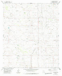 1984 Oil Center1984 Print · USGSThe high desert of Lea County is captured here during the 1980s energy boom, centered on the settlement of Oil Center. Researchers can trace the extensive oil and gas infrastructure across the Monument Jal Oil Field, locating named sites like the Scarbrough Well and Rock Lake Reservoir.
End of results
Showing maps 1-5 of 5
Top cities near Oil Center
Frequently asked questions
- What are the different types of historical maps available for Oil Center?
- What is the oldest map of Oil Center?
- Where can I purchase historical maps of Oil Center for my home or office?
- Where can I download high-res historical maps of Oil Center?
- Are there historical topographic maps available for Oil Center?
- Is there historical aerial imagery available for Oil Center?
- Where are historical maps of Oil Center sourced from?