1980s Maps of Polly, New Mexico
Explore 2 historic maps of Polly from the 1980s. These maps offer a rare glimpse into what life looked like during the 1980s — showing old roads, neighborhoods, homes, and landmarks that have changed or disappeared over time.
Whether you're researching your family's past, planning a metal detecting trip, or studying how Polly's landscape evolved across the 1980s, these high-resolution maps are a powerful tool for exploring the history of this region.
- Focus on a specific era: All maps on this page are from the 1980s, giving you a focused view of this time period.
- See what’s changed: Compare century-old streets, trails, and buildings to today's modern landscape using overlays and satellite layers.
- Research with precision: Use these maps for genealogy, historical research, land use analysis, or educational projects.
- View, download, or print: Maps are fully viewable online in high resolution, and can be downloaded or printed for your own records.
Start exploring Polly's history through authentic maps from the 1980s. This is your window into the past.
Polly, NM maps
(2)- 1981 Map of Carrizozo
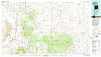 1981 Carrizozo1981 Print · USGSHigh desert plains meet the timbered slopes of the Capitan and Jicarilla Mountains in the early 1980s. Genealogists and historians can trace rail-side towns like Carrizozo and old mining sites such as the American Mine and the settlement of White Oaks.2 unique versions available
 - 1981 Map of Cub Mountain, 1982 Print
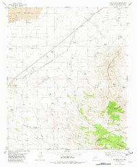 1981 Cub Mountain1982 Print · USGSLincoln County’s high desert and volcanic fields are documented here in the early eighties. Genealogists and historians can trace ranching outposts like Ham Windmill or the industrial footprint of the Southern Pacific and several upland Mines.
End of results
Showing maps 1-2 of 2
Top cities near Polly
Frequently asked questions
- What are the different types of historical maps available for Polly?
- What is the oldest map of Polly?
- Where can I purchase historical maps of Polly for my home or office?
- Where can I download high-res historical maps of Polly?
- Are there historical topographic maps available for Polly?
- Is there historical aerial imagery available for Polly?
- Where are historical maps of Polly sourced from?