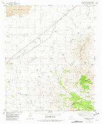
1981 Map of Cub Mountain
USGS Topo · Published 1982About this map
The Malpais lava flows dominate the northwestern corner of this Lincoln County survey, providing a sharp contrast to the high elevations of Cub Mountain and Chaves Mountain to the southeast. The landscape is defined by its water-scarcity infrastructure, with named points like Byron Well, Ham Windmill, and Goddard Windmill marking vital outposts for survival in the arid terrain. Transportation and industry are evidenced by the Southern Pacific railroad line and an Old RR Grade, which cross the drainage patterns of Willow Chaves Draw and Polly Draw. Small-scale extractive activity is visible near Little Cub, where several Mines are noted along the slopes. This 1981 edition captures the complex interplay of volcanic geology and ranching history, where family-named landmarks like Jakes Hill and Steel Hill serve as navigational anchors amidst the limestone and basalt.
Find a feature on this map
45 named features on this map. Tap any name to fly to it.
Don’t see what you’re looking for? This feature index may not catch every label — zoom into the map to look around manually.
Map Details
Editions of this 1981 Cub Mountain Map
This is the sole edition of this map. No revisions or reprints were ever made.
Other maps of this area

1916 · Tularosa
USGS Topo · 1:125,000

1918 · Oscura Peak
USGS Topo · 1:125,000

1938 · Carrizozo
USGS Topo · 1:48,000

1943 · Carrizozo
USGS Topo · 1:62,500

1947 · Three Rivers
USGS Topo · 1:62,500

1948 · Chihuahua Ranch
USGS Topo · 1:62,500

1950 · Oscura
USGS Topo · 1:24,000

1950 · Carrizozo
USGS Topo · 1:62,500

1950 · Sierra Blanca Peak
USGS Topo · 1:62,500

1954 · Tularosa
USGS Topo · 1:250,000