1900s (20th Century) Maps of Cloudcroft, New Mexico
Explore 7 historic maps of Cloudcroft from the 1900s (20th Century). These maps offer a rare glimpse into what life looked like during the 1900s — showing old roads, neighborhoods, homes, and landmarks that have changed or disappeared over time.
Whether you're researching your family's past, planning a metal detecting trip, or studying how Cloudcroft's landscape evolved across the 1900s, these high-resolution maps are a powerful tool for exploring the history of this region.
- Focus on a specific era: All maps on this page are from the 1900s, giving you a focused view of this time period.
- See what’s changed: Compare century-old streets, trails, and buildings to today's modern landscape using overlays and satellite layers.
- Research with precision: Use these maps for genealogy, historical research, land use analysis, or educational projects.
- View, download, or print: Maps are fully viewable online in high resolution, and can be downloaded or printed for your own records.
Start exploring Cloudcroft's history through authentic maps from the 1900s. This is your window into the past.
Cloudcroft, NM maps
(7)- 1950 Map of Alamogordo, 1955 Print
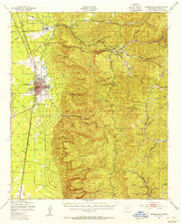 1950 Alamogordo1955 Print · USGSMid-century Alamogordo and the Sacramento Mountains are captured here during a period of steady growth and high-altitude development. Researchers can trace the Southern Pacific rail line, locate the State Sch For Blind, or find mountain sites like High Rolls and the Warnock Mine.3 unique versions available
 - 1952 Map of Cloudcroft, 1954 Print
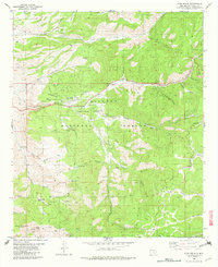
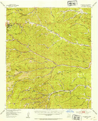 1952 Cloudcroft1954 Print · USGSHigh in the Sacramento Mountains during the early fifties, this area centers on the alpine community of Cloudcroft. Local researchers can trace family landmarks like the Weed Cem, St Joseph Church, and the Artesia Camp.3 unique versions available
 - 1954 Map of Carlsbad, 1963 Print
 1954 Carlsbad1963 Print · USGSSoutheastern New Mexico's desert peaks and river valleys appear in this mid-century study of the borderlands. Researchers can locate vanished sites like Sacramento City, trace the Pecos River reservoirs, and explore Carlsbad Caverns.3 unique versions available
 - 1958 Map of Carlsbad
 1958 Carlsbad1958 Print · USGSSoutheastern New Mexico in the mid-1950s shows a landscape of deep desert basins and high forest ranges during a period of steady ranching and early tourism. Researchers can trace the path of the Atchison Topeka and Santa Fe railroad or find vanished locales like Sacramento City (abandoned) and Whites City.2 unique versions available
 - 1977 Map of Cloudcroft, 1978 Print
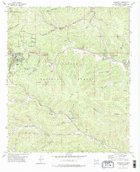 1977 Cloudcroft1978 Print · USGSCloudcroft and the surrounding high timber of the Sacramento Mountains are detailed here in the late seventies. Researchers can trace family history at Bassi Cem or locate old sites like Russia, Wimsatt, and the Wofford Lookout Tower.
 - 1979 Map of Alamogordo
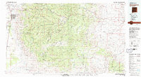 1979 Alamogordo1979 Print · USGSThe high Sacramento Mountains and the Tularosa Valley floor meet in the late seventies, showing the region's unique mix of scientific research and military land use. Genealogists and historians can trace routes to Cloudcroft, the Solar Observatory, and the McGregor Range.
 - 1982 Map of High Rolls
 1982 High Rolls1982 Print · USGSHigh Rolls and the surrounding Sacramento Mountains are shown in the early eighties as a landscape of timber-era transit and canyon-side settlements. Researchers can trace the path of the Old Railroad Grade or locate local landmarks like the Courtney Mine and Skyline Ranch.
End of results
Showing maps 1-7 of 7
Top cities near Cloudcroft
Frequently asked questions
- What are the different types of historical maps available for Cloudcroft?
- What is the oldest map of Cloudcroft?
- Where can I purchase historical maps of Cloudcroft for my home or office?
- Where can I download high-res historical maps of Cloudcroft?
- Are there historical topographic maps available for Cloudcroft?
- Is there historical aerial imagery available for Cloudcroft?
- Where are historical maps of Cloudcroft sourced from?