1980s Maps of Portales, New Mexico
Explore 2 historic maps of Portales from the 1980s. These maps offer a rare glimpse into what life looked like during the 1980s — showing old roads, neighborhoods, homes, and landmarks that have changed or disappeared over time.
Whether you're researching your family's past, planning a metal detecting trip, or studying how Portales's landscape evolved across the 1980s, these high-resolution maps are a powerful tool for exploring the history of this region.
- Focus on a specific era: All maps on this page are from the 1980s, giving you a focused view of this time period.
- See what’s changed: Compare century-old streets, trails, and buildings to today's modern landscape using overlays and satellite layers.
- Research with precision: Use these maps for genealogy, historical research, land use analysis, or educational projects.
- View, download, or print: Maps are fully viewable online in high resolution, and can be downloaded or printed for your own records.
Start exploring Portales's history through authentic maps from the 1980s. This is your window into the past.
Portales, NM maps
(2)- 1985 Map of Portales
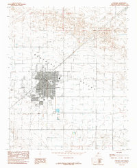 1985 Portales1985 Print · USGSPortales was a growing university town and railroad hub in the mid-1980s, serving the surrounding ranchlands. Genealogists and local historians can trace the development of Eastern New Mexico University and locate landmarks like Bethel Ch and the Cem.
 - 1985 Map of Bethel
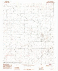 1985 Bethel1985 Print · USGSEastern New Mexico's ranching and agricultural heartland is captured here in the mid-eighties, showing the transition from open plains to managed water resources. Researchers can trace the layout of small communities like Bethel and Yerba or locate family-named landmarks such as Tinsley Crossing and Chalk Hill.
End of results
Showing maps 1-2 of 2
Top cities near Portales
Frequently asked questions
- What are the different types of historical maps available for Portales?
- What is the oldest map of Portales?
- Where can I purchase historical maps of Portales for my home or office?
- Where can I download high-res historical maps of Portales?
- Are there historical topographic maps available for Portales?
- Is there historical aerial imagery available for Portales?
- Where are historical maps of Portales sourced from?