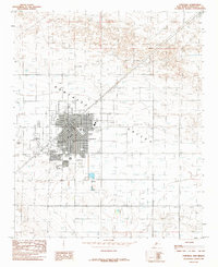
1985 Map of Portales
USGS Topo · Published 1985About this map
Portales serves as the focal point of this Roosevelt County survey, showing the city's structured layout and its intersection with the Atchison Topeka and Santa Fe railroad line. The presence of Eastern New Mexico University at the heart of the community highlights the town's role as a regional educational hub during the mid-1980s. Surrounding the urban center, the landscape is defined by the agricultural and industrial infrastructure of the Portales Valley, featuring a Grain Elevator, a Feed lot, and numerous water extraction points such as Well 4100T.
Find a feature on this map
92 named features on this map. Tap any name to fly to it.
Don’t see what you’re looking for? This feature index may not catch every label — zoom into the map to look around manually.
Map Details
Editions of this 1985 Portales Map
This is the sole edition of this map. No revisions or reprints were ever made.
Other maps of this area

1954 · Clovis
USGS Topo · 1:250,000

1957 · Portair
USGS Topo · 1:62,500

1957 · Clovis
USGS Topo · 1:62,500

1957 · Arch
USGS Topo · 1:62,500

1957 · Portales
USGS Topo · 1:62,500

1958 · Clovis
USGS Topo · 1:250,000

1985 · Midway
USGS Topo · 1:24,000
1985 · Portales SE
USGS Topo · 1:24,000
1985 · Delphos
USGS Topo · 1:24,000
1985 · Arch
USGS Topo · 1:24,000