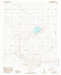
1985 Map of Arch
USGS Topo · Published 1985About this map
Portales Valley defines the northern reaches of this high plains landscape, where the small community of Arch serves as a lone hub of settlement near the Texas state line. The terrain is marked by a complex system of depressions and intermittent water sources, most notably the basin of Little Salt Lake. This saline feature is complemented by a series of localized catchments including West Tank, Middle Tank, and East Tank, reflecting the essential nature of water management in this arid agricultural region. A lone Landing Strip near the northeastern corner suggests the importance of aerial access for ranching operations or crop management during the mid-1980s. The map illustrates a grid-like pattern of rural roads and section lines typical of the Llano Estacado, showing how human habitation has adapted to the broad, flat topography of Roosevelt County.
Find a feature on this map
7 named features on this map. Tap any name to fly to it.
Don’t see what you’re looking for? This feature index may not catch every label — zoom into the map to look around manually.
Map Details
Editions of this 1985 Arch Map
This is the sole edition of this map. No revisions or reprints were ever made.
Other maps of this area

1954 · Clovis
USGS Topo · 1:250,000

1954 · Brownfield
USGS Topo · 1:250,000

1957 · Arch
USGS Topo · 1:62,500

1957 · Portales
USGS Topo · 1:62,500

1958 · Brownfield
USGS Topo · 1:250,000

1958 · Clovis
USGS Topo · 1:250,000

1962 · Brownfield
USGS Topo · 1:250,000

1970 · Causey East
USGS Topo · 1:24,000
1972 · Causey West
USGS Topo · 1:24,000

1972 · Dora
USGS Topo · 1:24,000