1960s Maps of Las Vegas, New Mexico
Explore 3 historic maps of Las Vegas from the 1960s. These maps offer a rare glimpse into what life looked like during the 1960s — showing old roads, neighborhoods, homes, and landmarks that have changed or disappeared over time.
Whether you're researching your family's past, planning a metal detecting trip, or studying how Las Vegas's landscape evolved across the 1960s, these high-resolution maps are a powerful tool for exploring the history of this region.
- Focus on a specific era: All maps on this page are from the 1960s, giving you a focused view of this time period.
- See what’s changed: Compare century-old streets, trails, and buildings to today's modern landscape using overlays and satellite layers.
- Research with precision: Use these maps for genealogy, historical research, land use analysis, or educational projects.
- View, download, or print: Maps are fully viewable online in high resolution, and can be downloaded or printed for your own records.
Start exploring Las Vegas's history through authentic maps from the 1960s. This is your window into the past.
Las Vegas, NM maps
(3)- 1961 Map of Ojitos Frios, 1966 Print
 1961 Ojitos Frios1966 Print · USGSSan Miguel County is captured here in the early sixties, showing the rural ranching life and early settlements southwest of Las Vegas. Researchers can trace the grounds of Ojitos Frios, locate the Santo Niño Ch, and follow the ridge of The Creston.
 - 1963 Map of Las Vegas, 1965 Print
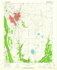 1963 Las Vegas1965 Print · USGSLas Vegas, New Mexico, serves as a bustling rail and trail hub in the early sixties. Genealogists and historians can trace family sites from Romeroville to the campus of Highlands University and along the historic Santa Fe Trail.
 - 1963 Map of Las Vegas NW, 1965 Print
 1963 Las Vegas NW1965 Print · USGSNorth of the city in the early sixties, this area shows the historic intersection of the Old Santa Fe Trail and the high-altitude irrigation of the Storrie Lake project. Researchers can locate St Anthonys Cemetery, the Santo Nino Ch, and early aviation at the Las Vegas Municipal Airport.
End of results
Showing maps 1-3 of 3
Frequently asked questions
- What are the different types of historical maps available for Las Vegas?
- What is the oldest map of Las Vegas?
- Where can I purchase historical maps of Las Vegas for my home or office?
- Where can I download high-res historical maps of Las Vegas?
- Are there historical topographic maps available for Las Vegas?
- Is there historical aerial imagery available for Las Vegas?
- Where are historical maps of Las Vegas sourced from?