1950s Maps of Jemez Springs, New Mexico
Explore 3 historic maps of Jemez Springs from the 1950s. These maps offer a rare glimpse into what life looked like during the 1950s — showing old roads, neighborhoods, homes, and landmarks that have changed or disappeared over time.
Whether you're researching your family's past, planning a metal detecting trip, or studying how Jemez Springs's landscape evolved across the 1950s, these high-resolution maps are a powerful tool for exploring the history of this region.
- Focus on a specific era: All maps on this page are from the 1950s, giving you a focused view of this time period.
- See what’s changed: Compare century-old streets, trails, and buildings to today's modern landscape using overlays and satellite layers.
- Research with precision: Use these maps for genealogy, historical research, land use analysis, or educational projects.
- View, download, or print: Maps are fully viewable online in high resolution, and can be downloaded or printed for your own records.
Start exploring Jemez Springs's history through authentic maps from the 1950s. This is your window into the past.
Jemez Springs, NM maps
(3)- 1952 Map of Jemez Springs, 1954 Print
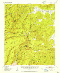 1952 Jemez Springs1954 Print · USGSThe Jemez Mountains in the early fifties reveal a landscape of thermal springs and high-altitude ranching within the national forest. Trace the development of local landmarks like Jemez Springs, the Soda Dam, and the early layout of Camp Shaver.3 unique versions available
 - 1952 Map of Jemez, 1962 Print
 1952 Jemez1962 Print · USGSSandoval County's canyon lands and pueblo grants are captured here during the early fifties, showing a transition from traditional land use to modern forestry and mining. Genealogists and historians can trace the foundations of Jemez Pueblo, the Spanish Queen Mine, and the route of the Bland Bear Springs Trail.
 - 1958 Map of Albuquerque
 1958 Albuquerque1958 Print · USGSAlbuquerque and the surrounding high desert are captured here during a period of massive federal expansion and postwar growth. Researchers can trace the development of Kirtland Air Force Base, find ancestral homes in Pueblo de Santa Ana, or locate industrial sites like the Jackpile Mine.
End of results
Showing maps 1-3 of 3
Top cities near Jemez Springs
Frequently asked questions
- What are the different types of historical maps available for Jemez Springs?
- What is the oldest map of Jemez Springs?
- Where can I purchase historical maps of Jemez Springs for my home or office?
- Where can I download high-res historical maps of Jemez Springs?
- Are there historical topographic maps available for Jemez Springs?
- Is there historical aerial imagery available for Jemez Springs?
- Where are historical maps of Jemez Springs sourced from?