1970s Maps of Jemez Springs, New Mexico
Explore 3 historic maps of Jemez Springs from the 1970s. These maps offer a rare glimpse into what life looked like during the 1970s — showing old roads, neighborhoods, homes, and landmarks that have changed or disappeared over time.
Whether you're researching your family's past, planning a metal detecting trip, or studying how Jemez Springs's landscape evolved across the 1970s, these high-resolution maps are a powerful tool for exploring the history of this region.
- Focus on a specific era: All maps on this page are from the 1970s, giving you a focused view of this time period.
- See what’s changed: Compare century-old streets, trails, and buildings to today's modern landscape using overlays and satellite layers.
- Research with precision: Use these maps for genealogy, historical research, land use analysis, or educational projects.
- View, download, or print: Maps are fully viewable online in high resolution, and can be downloaded or printed for your own records.
Start exploring Jemez Springs's history through authentic maps from the 1970s. This is your window into the past.
Jemez Springs, NM maps
(3)- 1970 Map of Ponderosa, 1973 Print
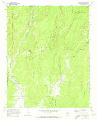 1970 Ponderosa1973 Print · USGSThe high mesas of Sandoval County come alive in this early 1970s survey, showing a landscape shaped by canyon-floor villages and ancient heights. Researchers can trace the cultural history of Ponderosa and Cañon through landmarks like Santo Toribio Ch and the Spanish Queen Mine.2 unique versions available
 - 1970 Map of Jemez Springs, 1973 Print
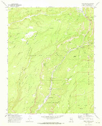 1970 Jemez Springs1973 Print · USGSIn the 1970s, Jemez Springs was already a gateway to the high mesas and deep canyons of the Jemez Mountains. Researchers can trace historic sites like the Via Coeli Monastery, old Ruins, and landmarks like Soda Dam.3 unique versions available
 - 1978 Map of Los Alamos
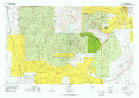 1978 Los Alamos1978 Print · USGSThe Jemez Mountains and Rio Grande valley come together in the late seventies, showing a land defined by volcanic peaks and ancient pueblos. Trace the footprints of Bandelier National Monument, find the rail line of the Atchison Topeka and Santa Fe, and locate historic settlements like Jemez Pueblo.
End of results
Showing maps 1-3 of 3
Top cities near Jemez Springs
Frequently asked questions
- What are the different types of historical maps available for Jemez Springs?
- What is the oldest map of Jemez Springs?
- Where can I purchase historical maps of Jemez Springs for my home or office?
- Where can I download high-res historical maps of Jemez Springs?
- Are there historical topographic maps available for Jemez Springs?
- Is there historical aerial imagery available for Jemez Springs?
- Where are historical maps of Jemez Springs sourced from?