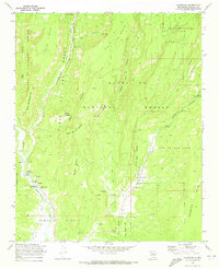
1970 Map of Ponderosa
USGS Topo · Published 1973About this map
The Jemez River and Rio Guadalupe converge in this high-mesa landscape, carving deep canyons that define the local settlement patterns. In the early 1970s, the village of Ponderosa sits at the base of Borrego Mesa, anchored by Santo Toribio Ch and a small cemetery. The mapping reveals a distinct spiritual and educational geography, featuring the Jemez Indian Mission and the Nuestra Senora de Guadalupe Ch near the community of Cañon.
Find a feature on this map
47 named features on this map. Tap any name to fly to it.
Don’t see what you’re looking for? This feature index may not catch every label — zoom into the map to look around manually.
Map Details
Editions of this 1970 Ponderosa Map
2 editions found
Other maps of this area

1890 · Jemes
USGS Topo · 1:125,000

1892 · Jemes
USGS Topo · 1:125,000

1937 · Jemez Springs
USGS Topo · 1:48,000

1939 · La Ventana
USGS Topo · 1:62,500

1939 · San Ysidro
USGS Topo · 1:62,500

1943 · San Ysidro
USGS Topo · 1:62,500

1943 · Jemez
USGS Topo · 1:62,500

1943 · La Ventana
USGS Topo · 1:62,500

1944 · Jemez Springs
USGS Topo · 1:62,500

1952 · Jemez Springs
USGS Topo · 1:62,500