1900s (20th Century) Maps of Dusty, New Mexico
Explore 5 historic maps of Dusty from the 1900s (20th Century). These maps offer a rare glimpse into what life looked like during the 1900s — showing old roads, neighborhoods, homes, and landmarks that have changed or disappeared over time.
Whether you're researching your family's past, planning a metal detecting trip, or studying how Dusty's landscape evolved across the 1900s, these high-resolution maps are a powerful tool for exploring the history of this region.
- Focus on a specific era: All maps on this page are from the 1900s, giving you a focused view of this time period.
- See what’s changed: Compare century-old streets, trails, and buildings to today's modern landscape using overlays and satellite layers.
- Research with precision: Use these maps for genealogy, historical research, land use analysis, or educational projects.
- View, download, or print: Maps are fully viewable online in high resolution, and can be downloaded or printed for your own records.
Start exploring Dusty's history through authentic maps from the 1900s. This is your window into the past.
Dusty, NM maps
(5)- 1954 Map of Tularosa, 1963 Print
 1954 Tularosa1963 Print · USGSSouth-central New Mexico in the early fifties shows a landscape of desert basins and high peaks under heavy military and water-reclamation use. Trace the path of the Atchison Topeka and Santa Fe Railway past San Marcial and into the massive White Sands Proving Ground.4 unique versions available
 - 1958 Map of Tularosa
 1958 Tularosa1958 Print · USGSSouthern New Mexico in the late fifties shows a landscape of military expansion and deep-rooted river settlements. Trace family history in Truth or Consequences or locate the ruins of San Marcial and the remote Dusty Post Office.2 unique versions available
 - 1965 Map of Dusty, 1967 Print
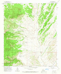 1965 Dusty1967 Print · USGSThe remote ranching country along the Socorro and Catron county line is captured in the mid-1960s, showing a landscape shaped by water and high-altitude grazing. Researchers can trace historic family holdings and landmarks like Henderson Ranch, Pigeon Cabin, and the isolated settlement of Dusty.
 - 1979 Map of San Mateo Mountains
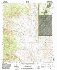
 1979 San Mateo Mountains1979 Print · USGSCentral New Mexico’s high desert and mountain ranges are captured here in the late seventies, showing the remote ranching and mining country of Socorro County. Researchers can locate historic sites like Fort Craig (Ruins), the Continental Divide, and isolated settlements like Dusty and Monticello.2 unique versions available
 - 1995 Map of Dusty, 1998 Print
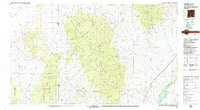
 1995 Dusty1998 Print · USGSSocorro and Catron counties appear here in the mid-1990s, revealing a landscape of high-country ranching and forest land. Genealogists and historians can locate family landmarks such as McCracken Ranch, Henderson Ranch, and the Pigeon Windmill.
End of results
Showing maps 1-5 of 5
Frequently asked questions
- What are the different types of historical maps available for Dusty?
- What is the oldest map of Dusty?
- Where can I purchase historical maps of Dusty for my home or office?
- Where can I download high-res historical maps of Dusty?
- Are there historical topographic maps available for Dusty?
- Is there historical aerial imagery available for Dusty?
- Where are historical maps of Dusty sourced from?