1960s Maps of Magdalena, New Mexico
Explore 3 historic maps of Magdalena from the 1960s. These maps offer a rare glimpse into what life looked like during the 1960s — showing old roads, neighborhoods, homes, and landmarks that have changed or disappeared over time.
Whether you're researching your family's past, planning a metal detecting trip, or studying how Magdalena's landscape evolved across the 1960s, these high-resolution maps are a powerful tool for exploring the history of this region.
- Focus on a specific era: All maps on this page are from the 1960s, giving you a focused view of this time period.
- See what’s changed: Compare century-old streets, trails, and buildings to today's modern landscape using overlays and satellite layers.
- Research with precision: Use these maps for genealogy, historical research, land use analysis, or educational projects.
- View, download, or print: Maps are fully viewable online in high resolution, and can be downloaded or printed for your own records.
Start exploring Magdalena's history through authentic maps from the 1960s. This is your window into the past.
Magdalena, NM maps
(3)- 1962 Map of Socorro
 1962 Socorro1962 Print · USGSCentral New Mexico comes alive in the early sixties as the rail-and-river corridor of the Rio Grande connects historic pueblos and ranching towns. Local historians can trace the route of the Atchison Topeka and Santa Fe through Belen or locate the Torrance Mine near Mountainair.
 - 1963 Map of Arroyo Landavaso, 1967 Print
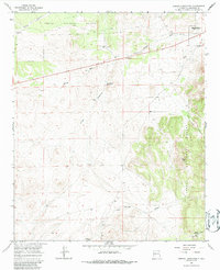 1963 Arroyo Landavaso1967 Print · USGSMagdalena sat at the edge of the desert wilderness in the early sixties, where ranching life relied on a network of remote wells and reservoirs. Researchers can trace historic water sources like Boxcar Well and Landavaso Reservoir near the slopes of Cerro Pelon.2 unique versions available
 - 1964 Map of Silver Hill, 1967 Print
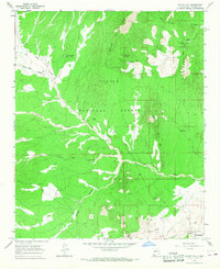 1964 Silver Hill1967 Print · USGSSocorro County ranching life in the mid-sixties is centered here among the high desert canyons and mountains. Genealogists and local historians can trace legacy landholdings like Bear Springs Ranch and Pueblito Ranch alongside ancient Indian Ruins.2 unique versions available
End of results
Showing maps 1-3 of 3
Top cities near Magdalena
Frequently asked questions
- What are the different types of historical maps available for Magdalena?
- What is the oldest map of Magdalena?
- Where can I purchase historical maps of Magdalena for my home or office?
- Where can I download high-res historical maps of Magdalena?
- Are there historical topographic maps available for Magdalena?
- Is there historical aerial imagery available for Magdalena?
- Where are historical maps of Magdalena sourced from?