
1963 Map of Arroyo Landavaso
USGS Topo · Published 1967About this map
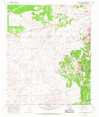
Magdalena serves as the primary landmark in this high-desert landscape, situated just north of the Cibola National Forest boundary. The 1963 survey captures a terrain defined by intermittent drainages and essential water infrastructure, including the Landavaso Reservoir and named drainage systems like Arroyo Landavaso and Arroyo Montosa. The map provides a detailed record of water sources critical for ranching and livestock in Socorro County, featuring family-named or location-specific wells such as High Well, Boxcar Well, and the Gosey Well. To the southeast, the topography becomes more complex around Cerro Pelon and the deep cuts of Texas Canyon and Agua Frio Canyon. These features, along with the isolated Texas Spring, illustrate the sparse but deliberate human imprint on this arid region during the mid-20th century.
Find a feature on this map
20 named features on this map. Tap any name to fly to it.
Don’t see what you’re looking for? This feature index may not catch every label — zoom into the map to look around manually.
Map Details
Editions of this 1963 Arroyo Landavaso Map
2 editions found
Other maps of this area

1954 · Tularosa
USGS Topo · 1:250,000

1954 · Socorro
USGS Topo · 1:250,000

1958 · Socorro
USGS Topo · 1:250,000

1958 · Tularosa
USGS Topo · 1:250,000

1959 · Magdalena
USGS Topo · 1:62,500

1962 · Socorro
USGS Topo · 1:250,000

1964 · Silver Hill
USGS Topo · 1:24,000

1964 · Tres Montosas
USGS Topo · 1:24,000

1964 · Gallinas Peak
USGS Topo · 1:24,000
1965 · Squaw Peak
USGS Topo · 1:24,000