1990s Maps of Magdalena, New Mexico
Explore 4 historic maps of Magdalena from the 1990s. These maps offer a rare glimpse into what life looked like during the 1990s — showing old roads, neighborhoods, homes, and landmarks that have changed or disappeared over time.
Whether you're researching your family's past, planning a metal detecting trip, or studying how Magdalena's landscape evolved across the 1990s, these high-resolution maps are a powerful tool for exploring the history of this region.
- Focus on a specific era: All maps on this page are from the 1990s, giving you a focused view of this time period.
- See what’s changed: Compare century-old streets, trails, and buildings to today's modern landscape using overlays and satellite layers.
- Research with precision: Use these maps for genealogy, historical research, land use analysis, or educational projects.
- View, download, or print: Maps are fully viewable online in high resolution, and can be downloaded or printed for your own records.
Start exploring Magdalena's history through authentic maps from the 1990s. This is your window into the past.
Magdalena, NM maps
(4)- 1995 Map of Magdalena, 1998 Print
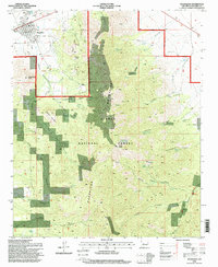 1995 Magdalena1998 Print · USGSMagdalena and the mining settlement of Kelly are shown here in the 1990s as the high desert meets the Magdalena Mountains. Researchers can trace the legacy of resource extraction through numerous mines and prospects scattered near Kelly Gulch and Elephant Mountain.2 unique versions available
 - 1995 Map of Granite Mountain, 1998 Print
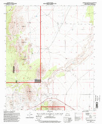 1995 Granite Mountain1998 Print · USGSSocorro County's high desert terrain is captured here in the mid-1990s, revealing a landscape of national forest land and mineral exploration. Genealogists and historians can trace the remote Cem and isolated Prospects near Granite Mountain.
 - 1995 Map of Silver Hill, 1998 Print
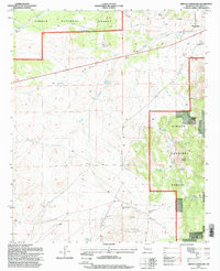
 1995 Silver Hill1998 Print · USGSRanching outposts and high desert terrain characterize this Socorro County landscape in the 1990s. Researchers can locate remote operations like Threemile Ranch, established water sources such as Bear Spring, and livestock features like the Allen Well Corral.
 - 1995 Map of Arroyo Landavaso, 1998 Print
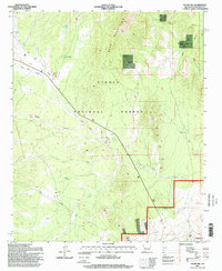
 1995 Arroyo Landavaso1998 Print · USGSSocorro County ranching and forest lands are captured here in the mid-1990s, highlighting a landscape shaped by water scarcity. Genealogists and researchers can trace local landmarks like Woodbury Ranch, the edge of Magdalena, and dozens of named water sources from Texas Well to Landavaso Reservoir.
End of results
Showing maps 1-4 of 4
Top cities near Magdalena
Frequently asked questions
- What are the different types of historical maps available for Magdalena?
- What is the oldest map of Magdalena?
- Where can I purchase historical maps of Magdalena for my home or office?
- Where can I download high-res historical maps of Magdalena?
- Are there historical topographic maps available for Magdalena?
- Is there historical aerial imagery available for Magdalena?
- Where are historical maps of Magdalena sourced from?