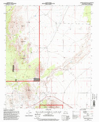
1995 Map of Granite Mountain
USGS Topo · Published 1998About this map
Cibola National Forest dominates this mid-1990s survey, defined by the prominent peak of Granite Mountain and the complex drainage of Bear Springs Canyon. The map reveals a landscape heavily shaped by small-scale mineral exploration, with numerous Prospects scattered across the higher elevations. This geological focus is paired with signs of isolated human activity, such as a remote Landing Strip and a Cem in the southern sector. Water remains a critical element of the high desert environment, marked by localized sources like Bird Spring, Goat Spring, and a designated Water Tank. These features, along with the course of La Jencia Creek, suggest a region where land use was primarily centered on ranching, resource assessment, and forest management rather than permanent settlement.
Find a feature on this map
11 named features on this map. Tap any name to fly to it.
Don’t see what you’re looking for? This feature index may not catch every label — zoom into the map to look around manually.
Map Details
Editions of this 1995 Granite Mountain Map
This is the sole edition of this map. No revisions or reprints were ever made.
Other maps of this area

1954 · Socorro
USGS Topo · 1:250,000

1958 · Socorro
USGS Topo · 1:250,000

1959 · Magdalena
USGS Topo · 1:62,500

1959 · Riley
USGS Topo · 1:62,500

1962 · Socorro
USGS Topo · 1:250,000

1963 · Arroyo Landavaso
USGS Topo · 1:24,000

1964 · Silver Hill
USGS Topo · 1:24,000
1964 · Mesa Cencerro
USGS Topo · 1:24,000
1979 · Magdalena
USGS Topo · 1:100,000
1985 · Granite Mountain
USGS Topo · 1:24,000