Old Maps of Abo, New Mexico for Academic Research
Study the evolution of Abo with 11 high-resolution historic maps. Whether you're teaching, researching, or modeling changes in land use, these maps provide essential visual documentation of urban, environmental, and geographic change.
- Analyze long-term change: Track patterns in development, transportation, and natural features.
- Ideal for environmental or urban studies: Support academic projects with primary historical map data.
- Use in the classroom or lab: Educators and researchers rely on these maps to bring historical context to life.
These maps are a powerful tool for teaching, research, and visualizing how Abo has changed over the decades.
Abo, NM maps
(11)- 1954 Map of Socorro, 1972 Print
 1954 Socorro1972 Print · USGSMid-century New Mexico comes into focus as the Rio Grande valley and the surrounding high desert undergo post-war growth. Genealogists and historians can trace old mountain settlements like Tajique and Punta de Agua or locate remote sites like the Torrance Mine.2 unique versions available
 - 1958 Map of Socorro
 1958 Socorro1958 Print · USGSNew Mexico's high desert during the late fifties reveals a landscape of massive land grants and remote mining outposts. Researchers can trace the path of the Atchison Topeka and Santa Fe railroad as it connects Socorro and Belen to industrial sites like the Manganese Mill.
 - 1962 Map of Socorro
 1962 Socorro1962 Print · USGSCentral New Mexico comes alive in the early sixties as the rail-and-river corridor of the Rio Grande connects historic pueblos and ranching towns. Local historians can trace the route of the Atchison Topeka and Santa Fe through Belen or locate the Torrance Mine near Mountainair.
 - 1972 Map of Abo, 1975 Print
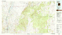
 1972 Abo1975 Print · USGSNew Mexico's high desert landscape comes into focus during the early seventies, centered on the ancient remains at Abo State Monument (Ruins). Trace the route of the Atchison Topeka and Santa Fe railroad or locate remote water sources like Wildcat Spring and Chilton Tank.
 - 1979 Map of Socorro
 1979 Socorro1979 Print · USGSThe Rio Grande corridor south of Belen comes into focus during the late seventies, showing the vital link between river-valley agriculture and high-desert ranching. Genealogists and historians can trace riverside settlements like Polvadera and La Joya or locate the Abo Mine and Dewey Lode Mine.2 unique versions available
 - 1995 Map of Abo, 1998 Print
 1995 Abo1998 Print · USGSTorrance County in the mid-1990s showcases a landscape of high-desert canyons and historic monument lands. Researchers can trace land use through stock tanks like Chilton Tank, the ruins at Salinas National Monument, and the winding Abo Arroyo.
 - 2011 Map of Abo, 2011 Print
 2011 Abo2011 Print · USGSCovers Abo, including Torrance County, United States, and other nearby areas
 - 2013 Map of Abo, 2013 Print
 2013 Abo2013 Print · USGSCovers Abo, including Torrance County, United States, and other nearby areas
 - 2017 Map of Abo, 2017 Print
 2017 Abo2017 Print · USGSCovers Abo, including Torrance County, United States, and other nearby areas
 - 2020 Map of Abo, 2020 Print
 2020 Abo2020 Print · USGSCovers Abo, including Torrance County, United States, and other nearby areas
 - 2023 Map of Abo, 2023 Print
 2023 Abo2023 Print · USGSTorrance County’s high-desert landscape in 2023 reveals a deep history of settlement and resource management near the Manzano Mountains. Researchers can trace the layout of Salinas Pueblo Missions National Monument, locate the San Lorenzo Cem, and follow the winding path of Abo Arroyo.
End of results
Showing maps 1-11 of 11
Top cities near Abo
Frequently asked questions
- What are the different types of historical maps available for Abo?
- What is the oldest map of Abo?
- Where can I purchase historical maps of Abo for my home or office?
- Where can I download high-res historical maps of Abo?
- Are there historical topographic maps available for Abo?
- Is there historical aerial imagery available for Abo?
- Where are historical maps of Abo sourced from?