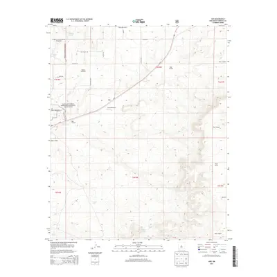
2013 Map of Abo
USGS Topo · Published 2013About this map
The Salinas Pueblo Missions National Monument and the adjacent Abo State Monument anchor this landscape in Torrance County, preserving the site of centuries-old cultural intersections. The settlement of Abo lies near the center, positioned along Us-60 and the prominent Abo Arroyo drainage system. The terrain is defined by complex canyon systems including Cañon Barranco, Goat Canyon, and Deer Canyon, which descend from the high ground of the Cibola National Forest in the northwest. Local ranching history is evidenced by numerous named water sources scattered across the desert, such as Chilton Tank, Phister Tank, and the W Latigo Tank. Historical travel routes are marked by the Old Abo Trl, providing a glimpse into the movement of people through these arid mountain passes before modern highways like Loma Parda Rd were established.
Find a feature on this map
32 named features on this map. Tap any name to fly to it.
Don’t see what you’re looking for? This feature index may not catch every label — zoom into the map to look around manually.
Map Details
Editions of this 2013 Abo Map
This is the sole edition of this map. No revisions or reprints were ever made.
Other maps of this area

1917 · Estancia
USGS Topo · 1:125,000

1954 · Torreon
USGS Topo · 1:62,500

1954 · Socorro
USGS Topo · 1:250,000

1956 · Mountainair
USGS Topo · 1:62,500

1958 · Socorro
USGS Topo · 1:250,000

1962 · Socorro
USGS Topo · 1:250,000

1972 · Chupadera
USGS Topo · 1:24,000

1972 · Bigbee Draw
USGS Topo · 1:24,000

1972 · Abo
USGS Topo · 1:24,000
1972 · Scholle
USGS Topo · 1:24,000