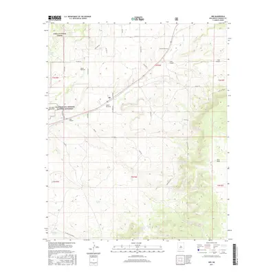
2017 Map of Abo
USGS Topo · Published 2017About this map
Abo State Monument and the surrounding Salinas Pueblo Missions National Monument serve as the focal point for this high-desert landscape in Torrance County. The terrain is defined by a series of dramatic watercourses and canyons, including the winding Abo Arroyo, Cañon Barranco, and Goat Canyon. This era of the map shows a network of rural roads and historical routes such as the Old Abo Trl and Cam De Aragon, which cross the rugged topography of the Cibola National Forest. Water management is evident throughout the dry country, with numerous livestock watering points like Chilton Tank, Squatty Tank, and White Tank distributed across the sections. The map also traces modern infrastructure like the El Paso Gas Pipeline Rd alongside older paths like the Deer Canyon Trl.
Find a feature on this map
44 named features on this map. Tap any name to fly to it.
Don’t see what you’re looking for? This feature index may not catch every label — zoom into the map to look around manually.
Map Details
Editions of this 2017 Abo Map
This is the sole edition of this map. No revisions or reprints were ever made.
Other maps of this area

1917 · Estancia
USGS Topo · 1:125,000

1954 · Torreon
USGS Topo · 1:62,500

1954 · Socorro
USGS Topo · 1:250,000

1956 · Mountainair
USGS Topo · 1:62,500

1958 · Socorro
USGS Topo · 1:250,000

1962 · Socorro
USGS Topo · 1:250,000

1972 · Chupadera
USGS Topo · 1:24,000

1972 · Bigbee Draw
USGS Topo · 1:24,000

1972 · Abo
USGS Topo · 1:24,000
1972 · Scholle
USGS Topo · 1:24,000