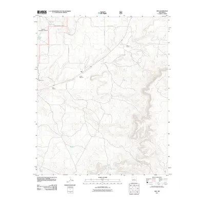
2011 Map of Abo
USGS Topo · Published 2011About this map
Abo State Monument anchors this high-desert landscape in Torrance County, preserving the ruins of a historic pueblo and mission at the foothills of the Manzano Mountains. The settlement of Abo sits at the intersection of a vast drainage network dominated by the Abo Arroyo, which carves a path through the terrain alongside Cañon Barranco and Deer Canyon. The landscape is characterized by its transition from the Cibola National Forest in the northwest to more open ranching lands in the south and east.
Find a feature on this map
23 named features on this map. Tap any name to fly to it.
Don’t see what you’re looking for? This feature index may not catch every label — zoom into the map to look around manually.
Map Details
Editions of this 2011 Abo Map
This is the sole edition of this map. No revisions or reprints were ever made.
Other maps of this area

1917 · Estancia
USGS Topo · 1:125,000

1954 · Torreon
USGS Topo · 1:62,500

1954 · Socorro
USGS Topo · 1:250,000

1956 · Mountainair
USGS Topo · 1:62,500

1958 · Socorro
USGS Topo · 1:250,000

1962 · Socorro
USGS Topo · 1:250,000

1972 · Chupadera
USGS Topo · 1:24,000

1972 · Bigbee Draw
USGS Topo · 1:24,000

1972 · Abo
USGS Topo · 1:24,000
1972 · Scholle
USGS Topo · 1:24,000