1980s Maps of Union County, New Mexico
Explore 5 historic maps of Union County from the 1980s. These maps offer a rare glimpse into what life looked like during the 1980s — showing old roads, neighborhoods, homes, and landmarks that have changed or disappeared over time.
Whether you're researching your family's past, planning a metal detecting trip, or studying how Union County's landscape evolved across the 1980s, these high-resolution maps are a powerful tool for exploring the history of this region.
- Focus on a specific era: All maps on this page are from the 1980s, giving you a focused view of this time period.
- See what’s changed: Compare century-old streets, trails, and buildings to today's modern landscape using overlays and satellite layers.
- Research with precision: Use these maps for genealogy, historical research, land use analysis, or educational projects.
- View, download, or print: Maps are fully viewable online in high resolution, and can be downloaded or printed for your own records.
Start exploring Union County's history through authentic maps from the 1980s. This is your window into the past.
Union County, NM maps
(5)- 1981 Map of Springer
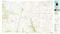 1981 Springer1981 Print · USGSNortheast New Mexico in the early eighties remains a landscape defined by its deep historical pathways and massive land grants. Genealogists and historians can trace the original Santa Fe Trail routes, the State Boys School at Springer, and the landmarks of Wagon Mound.
 - 1981 Map of Raton
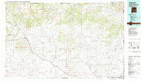
 1981 Raton1981 Print · USGSNorthern New Mexico's high mesas and mining corridors are preserved here as they appeared in the early eighties. Genealogists and historians can trace the transit networks of the Santa Fe Trail and find company towns like Van Houten and Koehler.
 - 1982 Map of Capulin Mountain
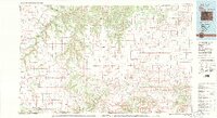
 1982 Capulin Mountain1982 Print · USGSNortheastern New Mexico in the early eighties remains a landscape defined by volcanic peaks and the historical tracks of the Santa Fe Trail. Researchers can trace old rail stops along the Colorado and Southern line and find landmarks like Rabbit Ear Mountain and Folsom.2 unique versions available
 - 1982 Map of Kim, 1983 Print
 1982 Kim1983 Print · USGSThe high plains of southern Colorado meet the New Mexico and Oklahoma borders in the early eighties. Genealogists and historians can trace the historic Santa Fe Trail and locate small ranching communities like Kim, Villegreen, and Utleyville.2 unique versions available
 - 1982 Map of Clayton, 1983 Print
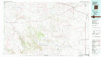 1982 Clayton1983 Print · USGSThe high plains of northeast New Mexico and the Texas panhandle appear here in the early eighties, centered on the ranching hub of Clayton. Genealogists and historians can trace the paths of the Colorado and Southern railroad or locate remote settlements like Miera, Beenham, and Sofia.
End of results
Showing maps 1-5 of 5
Top cities of Union County
Frequently asked questions
- What are the different types of historical maps available for Union County?
- What is the oldest map of Union County?
- Where can I purchase historical maps of Union County for my home or office?
- Where can I download high-res historical maps of Union County?
- Are there historical topographic maps available for Union County?
- Is there historical aerial imagery available for Union County?
- Where are historical maps of Union County sourced from?