1990s Maps of Union County, New Mexico
Explore 14 historic maps of Union County from the 1990s. These maps offer a rare glimpse into what life looked like during the 1990s — showing old roads, neighborhoods, homes, and landmarks that have changed or disappeared over time.
Whether you're researching your family's past, planning a metal detecting trip, or studying how Union County's landscape evolved across the 1990s, these high-resolution maps are a powerful tool for exploring the history of this region.
- Focus on a specific era: All maps on this page are from the 1990s, giving you a focused view of this time period.
- See what’s changed: Compare century-old streets, trails, and buildings to today's modern landscape using overlays and satellite layers.
- Research with precision: Use these maps for genealogy, historical research, land use analysis, or educational projects.
- View, download, or print: Maps are fully viewable online in high resolution, and can be downloaded or printed for your own records.
Start exploring Union County's history through authentic maps from the 1990s. This is your window into the past.
Union County, NM maps
(14)- 1996 Map of Furnish Canyon East, 2000 Print
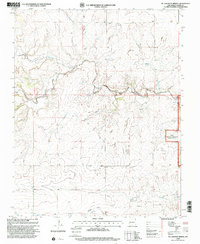
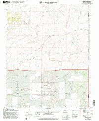
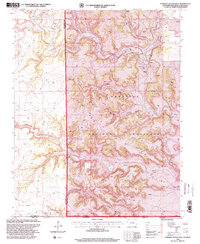 1996 Furnish Canyon East2000 Print · USGSThe tri-state border region of Colorado, New Mexico, and Oklahoma is shown here in the mid-1990s as a land of deep canyons and mesa tops. Researchers can trace remote 4WD trails to find the Dunlap Ranch, a lone Grave, and several scattered Mine sites.
 - 1998 Map of Clayton SW, 2001 Print
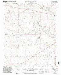
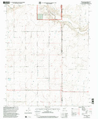
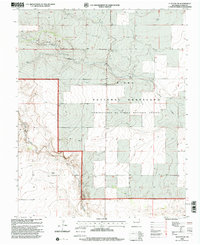 1998 Clayton SW2001 Print · USGSUnion County's high plains terrain is documented here in the late nineties, showing a landscape defined by ranching and federal land management. Genealogists can locate rural homesteads and settlements like Bates and Walker amidst the wide expanse of the Kiowa National Grassland.
 - 1998 Map of Clayton, 2001 Print
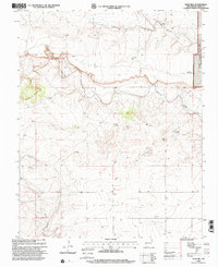
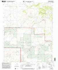
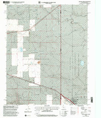
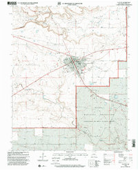 1998 Clayton2001 Print · USGSClayton stands as a vital rail and ranching center in Union County during the late nineties. Genealogists and local historians can trace civic landmarks like the Ioof Cem, the Drive-in Theater, and the sprawling Kiowa National Grassland.
 - 1998 Map of Divine Lake, 2001 Print
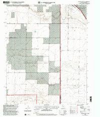
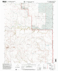
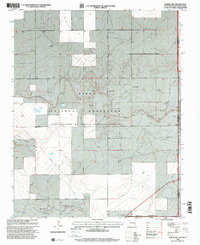
 1998 Divine Lake2001 Print · USGSNortheastern New Mexico's high plateau country is recorded here in the late nineties where Colfax and Harding counties meet. Genealogists and researchers can trace local landmarks like Mofax Cem, the Sugarloaf Ranch, and numerous family-named sites such as Sanders East Well.
 - 1998 Map of Texline South, 2001 Print
 1998 Texline South2001 Print · USGSThe Texas-New Mexico borderlands in the late nineties are captured here as a landscape of wide-open ranching and federal conservation. Genealogists and researchers can trace local landmarks like the Texline town site, the Circle H Farms Ltd Airport, and the Cem near the state line.
 - 1998 Map of Mc Laughlin Bridge, 2001 Print
 1998 Mc Laughlin Bridge2001 Print · USGSUnion County's high plains are revealed in the late nineties, where the historic SANTA FE TRAIL meets modern ranching. Trace family ties at Grandview Cem or locate the old crossing at Mc Laughlin Bridge and the Rohrer Windmill.
 - 1998 Map of Royce, 2001 Print
 1998 Royce2001 Print · USGSUnion County ranching and water management are on display in this late twentieth-century survey of the high plains. Researchers can locate remote family landmarks and burial sites like Antioch Cem, Mays Ranch, and several working water stations including Chili Windmill.
 - 1998 Map of Sand Hill, 2001 Print
 1998 Sand Hill2001 Print · USGSUnion County's high plains ranching country is documented here in the late twentieth century, showing the intersection of public lands and private holdings. Local researchers can locate Thomas Cem and trace the vital water infrastructure of the Kiowa National Grassland through Carrizo Windmill and Means Windmill.
 - 1998 Map of Rabbit Ear Mountain, 2001 Print
 1998 Rabbit Ear Mountain2001 Print · USGSNortheastern New Mexico's volcanic high plains are captured here in the late nineties, centered on the landmark heights of Rabbit Ear Mountain. Local history researchers can locate the Wanette Cem and trace ranching water sources such as Forty Acre Well and Eklund Well.
 - 1998 Map of Moses, 2001 Print
 1998 Moses2001 Print · USGSThe high plains of Union County are captured here in the late twentieth century, showing a landscape defined by the historic Santa Fe Trail. Genealogists and local historians can locate early burial sites like Puertocito Cem and landmarks such as the Knowles Sch and Old Moses.
 - 1998 Map of Sedan NE, 2001 Print
 1998 Sedan NE2001 Print · USGSThe high plains along the New Mexico-Texas border are shown here in the late twentieth century, showing a landscape shaped by ranching and conservation. Researchers can trace the boundary between Union County and Dallam County, finding numerous Well sites and the protected acreage of the Kiowa National Grassland.
 - 1998 Map of Seneca, 2001 Print
 1998 Seneca2001 Print · USGSNortheastern New Mexico's high plains are captured here in the late twentieth century, showing a landscape defined by ranching and historic transit. You can trace the path of the Cimarron Cutoff past landmarks like Lookout Hill and the settlement of Seneca.
 - 1998 Map of Rardin Hill, 2001 Print
 1998 Rardin Hill2001 Print · USGSThe high plains of Union County where New Mexico meets Oklahoma and Texas are captured here in the late nineties. Genealogists and local historians can locate Creeds Chapel Cem or trace ranching lifelines like Mock Windmill and Mason Windmill.
 - 1998 Map of Texline North, 2001 Print
 1998 Texline North2001 Print · USGSThe High Plains of the late nineties come alive at the meeting point of Texas and New Mexico in this detailed survey. Genealogists and historians can trace the foundations of this cattle-ranching region through the Texline townsite, the Clayton Livestock Research Center, and local landmarks like the Rodeo Ground.
End of results
Showing maps 1-14 of 14
Top cities of Union County
Frequently asked questions
- What are the different types of historical maps available for Union County?
- What is the oldest map of Union County?
- Where can I purchase historical maps of Union County for my home or office?
- Where can I download high-res historical maps of Union County?
- Are there historical topographic maps available for Union County?
- Is there historical aerial imagery available for Union County?
- Where are historical maps of Union County sourced from?