1990s Maps of Vestal, New York
Explore 2 historic maps of Vestal from the 1990s. These maps offer a rare glimpse into what life looked like during the 1990s — showing old roads, neighborhoods, homes, and landmarks that have changed or disappeared over time.
Whether you're researching your family's past, planning a metal detecting trip, or studying how Vestal's landscape evolved across the 1990s, these high-resolution maps are a powerful tool for exploring the history of this region.
- Focus on a specific era: All maps on this page are from the 1990s, giving you a focused view of this time period.
- See what’s changed: Compare century-old streets, trails, and buildings to today's modern landscape using overlays and satellite layers.
- Research with precision: Use these maps for genealogy, historical research, land use analysis, or educational projects.
- View, download, or print: Maps are fully viewable online in high resolution, and can be downloaded or printed for your own records.
Start exploring Vestal's history through authentic maps from the 1990s. This is your window into the past.
Vestal, NY maps
(2)- 1992 Map of Elmira, 1993 Print
 1992 Elmira1993 Print · USGSThe Finger Lakes and Southern Tier regions are captured in the early nineties as industrial hubs like Elmira and Endicott thrived alongside university life in Ithaca. Genealogists and researchers can trace the CONRAIL rail corridors, family hilltops such as Hornby Hill, and the extensive Newtown Battlefield Reservation.
 - 1992 Map of Laurel Lake, 1995 Print
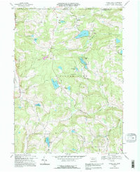 1992 Laurel Lake1995 Print · USGSSusquehanna County highland life at the New York border is preserved here, showing a landscape defined by glacial waters and rural industry. Trace family roots at St Augustine Ch or Brackney Cem, and locate old landmarks like Fisk Mill and Silver Lake.
End of results
Showing maps 1-2 of 2
Top cities near Vestal
- Union historical maps
- Binghamton historical maps
- Owego historical maps
- Johnson City historical maps
- Endicott historical maps
- Endwell historical maps
See more
Top neighborhoods of Vestal
- Willow Point historical maps
- Ross Corners historical maps
- Tracy Creek historical maps
- Twin Orchard historical maps
- South Vestal historical maps
- Tracy Creek historical maps
See more
Frequently asked questions
- What are the different types of historical maps available for Vestal?
- What is the oldest map of Vestal?
- Where can I purchase historical maps of Vestal for my home or office?
- Where can I download high-res historical maps of Vestal?
- Are there historical topographic maps available for Vestal?
- Is there historical aerial imagery available for Vestal?
- Where are historical maps of Vestal sourced from?