Old Maps of Vestal, New York for Academic Research
Study the evolution of Vestal with 61 high-resolution historic maps. Whether you're teaching, researching, or modeling changes in land use, these maps provide essential visual documentation of urban, environmental, and geographic change.
- Analyze long-term change: Track patterns in development, transportation, and natural features.
- Ideal for environmental or urban studies: Support academic projects with primary historical map data.
- Use in the classroom or lab: Educators and researchers rely on these maps to bring historical context to life.
These maps are a powerful tool for teaching, research, and visualizing how Vestal has changed over the decades.
Vestal, NY maps
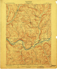
(61)- 1901 Map of Apalachin
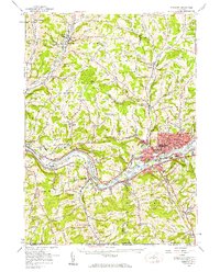
 1901 Apalachin1901 Print · USGSThe Susquehanna River valley at the start of the twentieth century shows the rise of industrial towns and old riverside settlements. Researchers can trace early rail corridors like the Auburn Div or locate family homesteads near Waite Settlement and Flemingsville.
 - 1904 Map of Binghamton
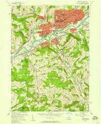
 1904 Binghamton1904 Print · USGSBinghamton at the turn of the century serves as the heart of a massive rail network where the Chenango and Susquehanna rivers meet. Researchers can trace the early layout of industrial Lestershire, the hill-station at Sanitaria Springs, and the diverse hamlets of New Ireland and Port Dickinson.9 unique versions available
 - 1904 Map of Apalachin
 1904 Apalachin1904 Print · USGSThe Susquehanna River valley at the turn of the century shows a landscape defined by heavy rail and early industry. Genealogists can trace family names and small upland hamlets like Waite Settlement, Oakley Cors, and Newark Valley before the modern highway era.8 unique versions available
 - 1906 Map of Catatonk
 1906 Catatonk1906 Print · USGSThe Southern Tier and Finger Lakes foothills are shown here at the peak of the rail era, before the expansion of modern highways. Genealogists can locate family lands near Slaterville Springs, trace the Lehigh Valley RR, or find early sites like White Church.
 - 1935 Map of Binghamton West
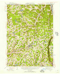
 1935 Binghamton West1935 Print · USGSBinghamton and its surrounding hill country are captured in the mid-1930s, showing the city's riverfront core alongside quiet rural settlements. Researchers can trace historic family names and community landmarks from Bible School Park to remote rural sites like Turkey Lane Sch and Hawleyton.
 - 1942 Map of Binghamton West
 1942 Binghamton West1942 Print · USGSThe river confluence and bustling rail corridors of the early 1940s define this area as it transitions from city streets to upland farms. Researchers can trace historic family landmarks and rural school sites such as Crocker Cem, Bunn Hill Ch, and the Turkey Lane Sch.2 unique versions available
 - 1943 Map of Montrose, 1957 Print
 1943 Montrose1957 Print · USGSSusquehanna County at the height of the mid-century railroad era shows a landscape of upland farms and valley rail junctions. Researchers can locate long-standing family landmarks and rural hubs like South Montrose, the Lehigh Valley line, and Prospect Hill Cem.3 unique versions available
 - 1943 Map of Le Raysville, 1960 Print
 1943 Le Raysville1960 Print · USGSNortheastern Pennsylvania hill country is captured here during the mid-forties as it straddled the border of Bradford and Susquehanna counties. Genealogists can trace family names and small-town roots through Little Meadows, Le Raysville, and numerous country burial sites like the Centerville Cem.2 unique versions available
 - 1945 Map of Montrose
 1945 Montrose1945 Print · USGSSusquehanna County is shown in the mid-1940s as a landscape of rural schoolhouses and established rail corridors. Genealogists and historians can locate family landmarks such as Prospect Hill Cem, tracing the paths between Montrose and the mills at Snows Mill.2 unique versions available
 - 1945 Map of Le Raysville
 1945 Le Raysville1945 Print · USGSThe borderlands of Susquehanna and Bradford counties are captured here in the mid-1940s, showing a landscape of small farming hamlets and upland ridges. Genealogists can trace family roots through numerous remote burial sites and schools like Fowler Hill Cem or Logan Hill Sch.2 unique versions available
 - 1948 Map of Binghamton, 1980 Print
 1948 Binghamton1980 Print · USGSCentral New York and the Southern Tier thrive in the late 1940s as a hub of rail traffic and mountain industry. Researchers can trace historic transit lines like the Erie Railroad through Binghamton or find old valley settlements near Oneonta and Delhi.
 - 1950 Map of Elmira
 1950 Elmira1950 Print · USGSThe Finger Lakes region thrived in the late 1940s as a hub of industry and transport. Trace family roots and vanished landmarks near Seneca Lake or explore the rail lines of the Erie RR and the sprawling Seneca Ordnance Depot.2 unique versions available
 - 1950 Map of Binghamton
 1950 Binghamton1950 Print · USGSBinghamton and the surrounding Southern Tier are shown in the mid-century era, highlighting the intricate rail and river networks that drove local industry. Researchers can trace the path of the Erie Railroad and locate landmarks from Otsego Lake to Sidney Mountain.2 unique versions available
 - 1950 Map of Scranton, 1952 Print
 1950 Scranton1952 Print · USGSMid-century Northeast Pennsylvania and the Hudson Valley come alive in this survey of the tri-state region. Genealogists and historians can trace the dense rail networks of the Erie RR and DL&W RR between industrial hubs like Scranton and Wilkes-Barre.
 - 1953 Map of Scranton
 1953 Scranton1953 Print · USGSNortheastern Pennsylvania and the Catskills are shown in great detail during the early fifties, a time when rail lines and river valleys dictated the region's growth. Genealogists and historians can trace the industrial hearts of Scranton and Wilkes-Barre or locate remote landmarks like High Point and Lake Wallenpaupack.
 - 1954 Map of Williamsport
 1954 Williamsport1954 Print · USGSNorth-central Pennsylvania in the mid-fifties is defined by the winding West Branch Susquehanna River and its industrial valley. Local historians can trace the massive Susquehanna Ordnance Depot and the extensive rail networks of the Pennsylvania Railroad.
 - 1956 Map of Endicott
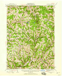
 1956 Endicott1956 Print · USGSThe Susquehanna River valley thrives in the mid-fifties as industrial centers and educational institutions expand across the Southern Tier. Researchers can trace the development of Harpur College, the busy Tri-Cities Airport, and established rural sites like St Johns Ch.4 unique versions available
 - 1956 Map of Endicott, 1958 Print
 1956 Endicott1958 Print · USGSThe industrial Susquehanna Valley thrives in the mid-fifties as urban growth expands toward the southern hills. Researchers can trace the development of ENDICOTT and Endwell or locate landmarks like Harpur College, Tri-Cities Airport, and Riverside Cem.2 unique versions available
 - 1958 Map of Binghamton
 1958 Binghamton1958 Print · USGSCentral New York in the late fifties was a network of manufacturing cities and river valleys connected by vital rail lines. Genealogists and historians can trace family roots in Oneonta, Norwich, and Cooperstown or locate long-standing farms along Schoharie Creek.
 - 1958 Map of Elmira
 1958 Elmira1958 Print · USGSThe New York Finger Lakes during the late fifties reveal a complex landscape of glacial geology and industrial growth. Researchers can trace historic transport corridors like the Erie Canal and Erie RR, or locate institutional landmarks like Cornell University.2 unique versions available
 - 1959 Map of Scranton
 1959 Scranton1959 Print · USGSThe northern coalfields and the Hudson Valley meet in this mid-century survey of the Pennsylvania and New York borderlands. Genealogists and historians can trace the intricate rail networks of the Erie Railroad and the vast waters of Lake Wallenpaupack.2 unique versions available
 - 1960 Map of Williamsport
 1960 Williamsport1960 Print · USGSNorth-central Pennsylvania in the mid-twentieth century was a vital corridor of rail and river industry stretching from the New York line to the coal regions. Genealogists can trace the rail networks of the Pennsylvania RR and Lehigh Valley RR connecting towns like Williamsport, Towanda, and Lock Haven.
 - 1961 Map of Binghamton West, 1964 Print
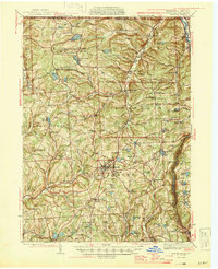
 1961 Binghamton West1964 Print · USGSBinghamton and Johnson City are shown in the early sixties as they developed around the Susquehanna and Chenango Rivers. Researchers can trace historic local institutions like Harpur College, Spring Forest Cemetery, and the Erie-Lackawanna rail lines.
 - 1962 Map of Williamsport, 1966 Print
 1962 Williamsport1966 Print · USGSNorth-central Pennsylvania was a landscape of industrial river hubs and vast state woodlands in the early sixties. Researchers can trace the path of the Pennsylvania Railroad through Williamsport and explore the remote reaches of Bucktail State Park.5 unique versions available
 - 1962 Map of Elmira, 1969 Print
 1962 Elmira1969 Print · USGSThe Finger Lakes region and Southern Tier are captured here during a period of industrial maturity and highway expansion. Researchers can trace the path of the Erie Canal, the footprint of the Seneca Army Depot, and legacy rail lines through Elmira and Ithaca.4 unique versions available
Showing maps 1-25 of 61
Top cities near Vestal
- Union historical maps
- Binghamton historical maps
- Owego historical maps
- Johnson City historical maps
- Endicott historical maps
- Endwell historical maps
See more
Top neighborhoods of Vestal
- Willow Point historical maps
- Ross Corners historical maps
- Tracy Creek historical maps
- Twin Orchard historical maps
- South Vestal historical maps
- Tracy Creek historical maps
See more
Frequently asked questions
- What are the different types of historical maps available for Vestal?
- What is the oldest map of Vestal?
- Where can I purchase historical maps of Vestal for my home or office?
- Where can I download high-res historical maps of Vestal?
- Are there historical topographic maps available for Vestal?
- Is there historical aerial imagery available for Vestal?
- Where are historical maps of Vestal sourced from?