1940s Maps of Cayuga County, New York
Explore 33 historic maps of Cayuga County from the 1940s. These maps offer a rare glimpse into what life looked like during the 1940s — showing old roads, neighborhoods, homes, and landmarks that have changed or disappeared over time.
Whether you're researching your family's past, planning a metal detecting trip, or studying how Cayuga County's landscape evolved across the 1940s, these high-resolution maps are a powerful tool for exploring the history of this region.
- Focus on a specific era: All maps on this page are from the 1940s, giving you a focused view of this time period.
- See what’s changed: Compare century-old streets, trails, and buildings to today's modern landscape using overlays and satellite layers.
- Research with precision: Use these maps for genealogy, historical research, land use analysis, or educational projects.
- View, download, or print: Maps are fully viewable online in high resolution, and can be downloaded or printed for your own records.
Start exploring Cayuga County's history through authentic maps from the 1940s. This is your window into the past.
Cayuga County, NY maps
(33)- 1942 Map of Ludlowville, 1956 Print
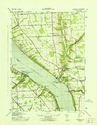
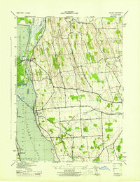
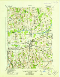
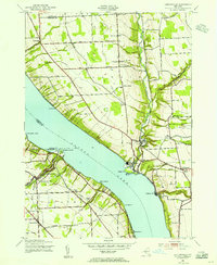 1942 Ludlowville1956 Print · USGSCayuga Lake and its dramatic ravines are captured here in the early 1940s, showing the intersection of lakeside industry and rural life. Researchers can trace the Lehigh Valley rail line past the Salt Works or find family roots near Ludlowville and German Cem.3 unique versions available
 - 1942 Map of Groton, 1956 Print
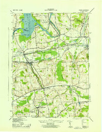
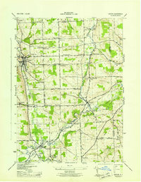
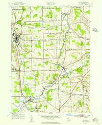 1942 Groton1956 Print · USGSTompkins County rural life is captured here during the early war years, showing a landscape defined by small hamlets and a remarkable number of local schools. Trace the old Lehigh Valley rail line and locate landmarks like the George Junior Republic or Red Mills.2 unique versions available
 - 1942 Map of Sheldrake, 1960 Print
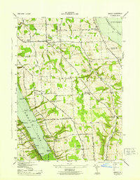
 1942 Sheldrake1960 Print · USGSThe shores of Cayuga Lake are captured here during the early 1940s, showcasing a rural landscape of crossroads hamlets and lakeside points. Genealogists can locate family landmarks like Parker Cem, Wells College, and the rail depot at King Ferry Sta.
 - 1942 Map of Genoa, 1960 Print
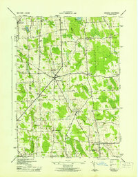
 1942 Genoa1960 Print · USGSSouthern Cayuga County during the early years of the war was a landscape of tightly-knit crossroad hamlets and rural school districts. Genealogists can trace family footprints across Poplar Ridge, Little Hollow, and multiple burial grounds like Maplewood Cem.
 - 1942 Map of Trumansburg, 1960 Print
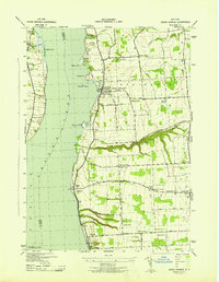
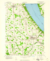 1942 Trumansburg1960 Print · USGSThe western shore of Cayuga Lake during the early years of the war shows a landscape of busy rail lines and lakeside landings. Researchers can trace family roots at Grove Cemetery or explore the rural layout of Trumansburg, Podunk, and Halseyville.
 - 1943 Map of Moravia
 1943 Moravia1943 Print · USGSSouthern Cayuga County's valley farms and steep ravines are captured here in the early 1940s, centered on the village of Moravia. Genealogists can trace family connections through numerous landmarks like Baker Cem, Wilson Corners, and a dozen district schools including School No 9.3 unique versions available
 - 1943 Map of Ludlowville
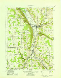
 1943 Ludlowville1943 Print · USGSThe Finger Lakes region during the early war years reveals a landscape of industrial lakeside sites and quiet upland farm districts. Genealogists and researchers can trace local roots through numerous landmarks like Pine Grove Cem, Jacksonville, and the Salt Works at Myers.
 - 1943 Map of Jordan
 1943 Jordan1943 Print · USGSJordan and Elbridge are centers of industry and transit during the mid-forties, where the old canal system meets the modern rail era. Trace the path of the ERIE CANAL, locate family roots at MAPLE GROVE CEM, or find old schoolhouses like School No 11 and School No 12.
 - 1943 Map of Lysander
 1943 Lysander1943 Print · USGSThe Seneca River valley in the early 1940s is shown here as a landscape of thriving rural hamlets and extensive canal infrastructure. Trace the network of old schoolhouses and cemeteries from Lysander to Plainville, or locate the family lands at Baird Corners.
 - 1943 Map of West Groton
 1943 West Groton1943 Print · USGSTompkins County was a landscape of close-knit farming hamlets and rural school districts in the years before mid-century. Genealogists can trace family names through landmarks like Munson Corner, the North Lansing Cem, and the path of the Lehigh Valley RR.3 unique versions available
 - 1943 Map of Montezuma
 1943 Montezuma1943 Print · USGSThe Cayuga County marshlands are captured here during the Second World War as the region’s massive river and canal systems were being managed for conservation. You can trace the early path of the Erie Canal (Abandoned) or find family sites near Port Byron and Murray Cem.
 - 1943 Map of Genoa
 1943 Genoa1943 Print · USGSSouthern Cayuga County appears as a network of rural hamlets and creek valleys in the early 1940s. Genealogists can trace family roots through numerous district schools and landmarks like King Ferry, Five Corners, and the Maplewood Cem.
 - 1943 Map of Oswego West
 1943 Oswego West1943 Print · USGSOswego and its harbor front on Lake Ontario during the early years of the war, showing a landscape defined by schools, chapels, and the historic Fort Ontario. Genealogists can trace early homesteads and communities near Fruit Valley, Irish Settlement Cem, and School No 10.
 - 1943 Map of Trumansburg
 1943 Trumansburg1943 Print · USGSThe western shores of Cayuga Lake come alive in this wartime survey, showing the agricultural heartland between Seneca and Tompkins Counties. Genealogists and local historians can trace family roots through sites like St James Cem, School No 24, and the lakeside landings at Bergen Beach.
 - 1943 Map of Cayuga
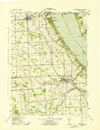
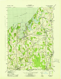
 1943 Cayuga1943 Print · USGSThe northern reaches of Cayuga Lake and the Montezuma wetlands are captured here during the early 1940s. Genealogists can locate family-named landmarks like Farnam Cem and Polk Corners, alongside the tracks of the New York Central Railroad.
 - 1943 Map of Spafford
 1943 Spafford1943 Print · USGSThe steep shorelines of Skaneateles and Otisco Lakes appear here during the mid-1940s. Genealogists and local historians can trace family locations through numerous named cemeteries like Kelloggsville Cem and schools such as School No 7.
 - 1943 Map of Groton
 1943 Groton1943 Print · USGSTompkins County during the 1940s is mapped here in detail, showing a landscape of established dairy farms and rail-dependent villages. Genealogists can trace family land via numerous crossroads like Jones Corners and find old schoolhouses including the Mud Schoolhouse Corners.
 - 1943 Map of Owasco
 1943 Owasco1943 Print · USGSThe Finger Lakes uplands between Owasco Lake and Skaneateles Lake are captured here during the mid-century. Researchers can trace numerous family-named landmarks and rural burial grounds like Owasco Rural Cem, Valentine Corners, and Frozen Ocean.2 unique versions available
 - 1943 Map of Cato
 1943 Cato1943 Print · USGSNorthwestern Cayuga County in the 1940s shows a landscape of drumlins and dairy farms centered on the village of Cato. Researchers can trace the path of the Lehigh Valley railroad and find historic local sites like Union Hill Cem and School No 9.
 - 1943 Map of Scipio
 1943 Scipio1943 Print · USGSInland from the shores of Owasco Lake during the early 1940s, this Cayuga County landscape is a meticulous grid of rural townships and family-named corners. Genealogists can trace family footprints across dozens of sites like Scipio Center, St Bernard Cem, and the Emily Howland High Sch.
 - 1943 Map of Hannibal
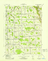
 1943 Hannibal1943 Print · USGSOswego and Cayuga counties are shown here during the war years, when the landscape was a dense network of family farms and rural school districts. Genealogists can trace family footprints through numerous numbered schools and local landmarks like Bethel Cem, Martville, and the Lehigh Valley railroad line.2 unique versions available
 - 1943 Map of Sheldrake
 1943 Sheldrake1943 Print · USGSCayuga Lake's eastern and western shores are captured here in the early 1940s, showing a landscape of deep gullies and lakeside rail stations. Genealogists can trace family names at Quaker Cem or locate former hubs like Kings Ferry Station and Wells College.
 - 1943 Map of Weedsport
 1943 Weedsport1943 Print · USGSMid-century Cayuga County is defined by its deep layering of transport history as the modern Barge Canal replaces the original Erie route. Researchers can trace the transition between eras at the Weedsport Canal Terminal and the Erie Canal (Abandoned), or locate family sites like La Due Cem and Brick Church.
 - 1943 Map of Union Springs
 1943 Union Springs1943 Print · USGSThe eastern shores of Cayuga Lake come to life in the 1940s as the rail-and-water economy supports bustling lakeside villages. Genealogists can locate family landmarks from Red Jacket Cem to Sherwood, alongside numerous rural schools and the Lehigh Valley line.
 - 1943 Map of Fair Haven
 1943 Fair Haven1943 Print · USGSThe Lake Ontario shoreline in Cayuga and Wayne Counties during the mid-1940s reveals a landscape of bays, orchards, and rural school districts. Genealogists can trace family names at Springbrook Cem or locate old rail stops at Sterling Junction and Crocketts.2 unique versions available
Showing maps 1-25 of 33
Top cities of Cayuga County
- Auburn historical maps
- Brutus historical maps
- Owasco historical maps
- Moravia historical maps
- Sennett historical maps
- Sterling historical maps
See more
Frequently asked questions
- What are the different types of historical maps available for Cayuga County?
- What is the oldest map of Cayuga County?
- Where can I purchase historical maps of Cayuga County for my home or office?
- Where can I download high-res historical maps of Cayuga County?
- Are there historical topographic maps available for Cayuga County?
- Is there historical aerial imagery available for Cayuga County?
- Where are historical maps of Cayuga County sourced from?