1900-1909 Maps of Cayuga County, New York
Explore 8 historic maps of Cayuga County from 1900-1909. These maps offer a rare glimpse into what life looked like during the 1900s — showing old roads, neighborhoods, homes, and landmarks that have changed or disappeared over time.
Whether you're researching your family's past, planning a metal detecting trip, or studying how Cayuga County's landscape evolved across the 1900s, these high-resolution maps are a powerful tool for exploring the history of this region.
- Focus on a specific era: All maps on this page are from the 1900s, giving you a focused view of this time period.
- See what’s changed: Compare century-old streets, trails, and buildings to today's modern landscape using overlays and satellite layers.
- Research with precision: Use these maps for genealogy, historical research, land use analysis, or educational projects.
- View, download, or print: Maps are fully viewable online in high resolution, and can be downloaded or printed for your own records.
Start exploring Cayuga County's history through authentic maps from the 1900s. This is your window into the past.
Cayuga County, NY maps
(8)- 1900 Map of Baldwinsville
 1900 Baldwinsville1900 Print · USGSOnondaga and Oswego counties are seen here at the close of the nineteenth century, when the Erie Canal still drove local commerce. Genealogists can trace family roots through canal towns like Jordan and river hubs like Baldwinsville and Phoenix.9 unique versions available
 - 1900 Map of Oswego
 1900 Oswego1900 Print · USGSThe Lake Ontario shoreline in Oswego and Cayuga Counties at the turn of the century is a hub of maritime and rail commerce. Genealogists and historians can trace the paths of four major railroads serving lakefront communities like North Fairhaven and the historic grounds of Fort Ontario.8 unique versions available
 - 1900 Map of Fulton
 1900 Fulton1900 Print · USGSOswego County at the turn of the century shows a bustling corridor of industry and agriculture along the Oswego River. Researchers can trace the legacy of vanished depots and hamlets like Bundy Crossing, Gilbert Mills, and Seneca Hill during the height of the steam-rail era.7 unique versions available
 - 1902 Map of Skaneateles
 1902 Skaneateles1902 Print · USGSOnondaga and Cayuga counties come alive in the Victorian era as a network of steamboats and short-line railroads connects lakeside hamlets. Trace ancestral roots and old transport routes through Mottville, the Skaneateles RR, and remote landings like Gregory Ldg.9 unique versions available
 - 1902 Map of Moravia
 1902 Moravia1902 Print · USGSThe rural landscapes of Cayuga and Tompkins counties are captured here at the start of the twentieth century, when small hamlets thrived along the rail lines. Genealogists can trace family names and vanished post offices at Goosetree, Morse Mill, and Grotto.7 unique versions available
 - 1902 Map of Genoa
 1902 Genoa1902 Print · USGSThe Finger Lakes region thrived on water and rail transport at the turn of the century, centered on the transit hub of Cayuga Lake. Genealogists and historians can trace the early Steamboat Route and find historic sites like Wells College and Taughannic Falls.8 unique versions available
 - 1902 Map of Weedsport
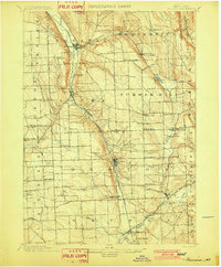
 1902 Weedsport1902 Print · USGSCentral New York at the turn of the century reveals a landscape shaped by the Erie Canal and a dense network of early railroads. Genealogists and historians can trace the foundations of Weedsport and Port Byron, or locate landmarks like the Brick Church and the Canal Basin at Montezuma.10 unique versions available
 - 1902 Map of Auburn
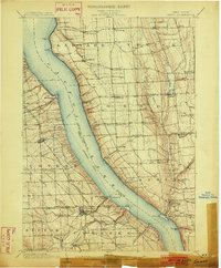
 1902 Auburn1902 Print · USGSThe Finger Lakes region thrived at the turn of the century as a hub of rail lines and canal traffic. Genealogists and historians can trace old homesteads and landings from Union Springs to Throopsville, including the complex rail junctions at Cayuga Junction and Aurelius Sta.9 unique versions available
End of results
Showing maps 1-8 of 8
Top cities of Cayuga County
- Auburn historical maps
- Brutus historical maps
- Owasco historical maps
- Moravia historical maps
- Sennett historical maps
- Sterling historical maps
See more
Frequently asked questions
- What are the different types of historical maps available for Cayuga County?
- What is the oldest map of Cayuga County?
- Where can I purchase historical maps of Cayuga County for my home or office?
- Where can I download high-res historical maps of Cayuga County?
- Are there historical topographic maps available for Cayuga County?
- Is there historical aerial imagery available for Cayuga County?
- Where are historical maps of Cayuga County sourced from?