1970s Maps of Cayuga County, New York
Explore 10 historic maps of Cayuga County from the 1970s. These maps offer a rare glimpse into what life looked like during the 1970s — showing old roads, neighborhoods, homes, and landmarks that have changed or disappeared over time.
Whether you're researching your family's past, planning a metal detecting trip, or studying how Cayuga County's landscape evolved across the 1970s, these high-resolution maps are a powerful tool for exploring the history of this region.
- Focus on a specific era: All maps on this page are from the 1970s, giving you a focused view of this time period.
- See what’s changed: Compare century-old streets, trails, and buildings to today's modern landscape using overlays and satellite layers.
- Research with precision: Use these maps for genealogy, historical research, land use analysis, or educational projects.
- View, download, or print: Maps are fully viewable online in high resolution, and can be downloaded or printed for your own records.
Start exploring Cayuga County's history through authentic maps from the 1970s. This is your window into the past.
Cayuga County, NY maps
(10)- 1970 Map of Genoa, 1974 Print
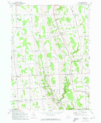 1970 Genoa1974 Print · USGSSouthern Cayuga County in the early seventies remained a landscape of rural hamlets and deep creek valleys. Genealogists can trace family names through landmarks like Genoa Cem and old crossroads such as Poplar Ridge and King Ferry.2 unique versions available
 - 1970 Map of West Groton, 1974 Print
 1970 West Groton1974 Print · USGSUpper Tompkins County is shown here in the early 1970s, characterized by its dense network of named rural crossroads and family homesteads. Genealogists and local historians can trace specific family landmarks like Pierson Corners, Stearns Cem, and the South Lansing School for Girls.2 unique versions available
 - 1970 Map of Trumansburg, 1974 Print
 1970 Trumansburg1974 Print · USGSThe western Cayuga Lake shoreline and the village of Trumansburg are shown here as they appeared in the early 1970s. Researchers can trace the Lehigh Valley RR, locate the Nun-Dak-Et Airfield, and find small settlements like Podunk and Waterburg.2 unique versions available
 - 1970 Map of Groton, 1974 Print
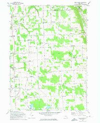
 1970 Groton1974 Print · USGSThe rural crossroads of Tompkins and Cortland counties are captured in the early 1970s, showing the enduring agricultural character of the region. Researchers can trace the Lehigh Valley rail line or locate family-named settlements like Morton Corners and Lacy Corners.2 unique versions available
 - 1971 Map of Sheldrake, 1974 Print
 1971 Sheldrake1974 Print · USGSCayuga Lake's shoreline in the early 1970s reveals a landscape of historic college grounds and deep-cut gullies. Trace the Lehigh Valley rail line or locate family landmarks like Prospect Corners, Jump Corners, and Wells College.2 unique versions available
 - 1971 Map of Sempronius, 1974 Print
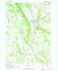
 1971 Sempronius1974 Print · USGSThe hills along the Cayuga and Cortland county line in the early seventies remain a landscape of deep gulfs and upland forests. Genealogists and hikers can trace the original locations of Morse Mill, Summer Hill Ch, and the Lickville Cem.
 - 1971 Map of Moravia, 1974 Print
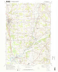
 1971 Moravia1974 Print · USGSSouthern Cayuga County in the early 1970s is defined by the steep valley of the Owasco Inlet and its vital rail corridor. Genealogists can trace family names at Indian Mound Cem or explore historic centers like Moravia and Locke.2 unique versions available
 - 1971 Map of Ludlowville, 1975 Print
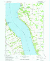
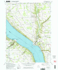 1971 Ludlowville1975 Print · USGSThe shores of Cayuga Lake in the early 1970s reveal a mix of Finger Lakes recreation and industrial transit. Researchers can trace the Lehigh Valley Railroad line, locate rural burial sites like Bower Cem, and explore the gorge at Taughannock Falls State Park.2 unique versions available
 - 1978 Map of Hannibal
 1978 Hannibal1978 Print · USGSThe intersection of Oswego and Cayuga counties comes into sharp focus during the late seventies, showing a landscape defined by crossroads hamlets and creek valleys. Researchers can trace local lineage through family sites like Mosher Cem and Bethel Cem, or locate landmarks such as Metcalf Siding and the Quarry.
 - 1978 Map of Jordan, 1979 Print
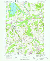 1978 Jordan1979 Print · USGSThe Seneca River valley in the late seventies reveals a landscape defined by its canal-era roots and rail connections. Genealogists can trace family names through Maple Grove Cem and Elbridge Rural Cem or locate the old Halfway Sch and St Patricks Ch.2 unique versions available
End of results
Showing maps 1-10 of 10
Top cities of Cayuga County
- Auburn historical maps
- Brutus historical maps
- Owasco historical maps
- Moravia historical maps
- Sennett historical maps
- Sterling historical maps
See more
Frequently asked questions
- What are the different types of historical maps available for Cayuga County?
- What is the oldest map of Cayuga County?
- Where can I purchase historical maps of Cayuga County for my home or office?
- Where can I download high-res historical maps of Cayuga County?
- Are there historical topographic maps available for Cayuga County?
- Is there historical aerial imagery available for Cayuga County?
- Where are historical maps of Cayuga County sourced from?