Old Maps of Greene, New York for Hiking & Exploration
Hike through history with 54 historic maps of Greene. Explore old trails, ghost towns, and forgotten backroads — perfect for outdoor adventurers and local explorers.
- Rediscover forgotten places: Map out old mining camps, roads, and footpaths that no longer exist on modern maps.
- Layer with modern tools: Combine with LiDAR or satellite views to plan hikes through historical terrain.
- Made for exploration: Popular among hikers, overlanders, and local history lovers.
Use these maps to find adventure and explore the hidden past of Greene.
Greene, NY maps
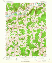
(54)- 1902 Map of Coventry
 1902 Coventry1902 Print · USGSChenango County at the start of the twentieth century was a landscape of hilltop farms and busy valley rail towns. Researchers can trace ancestral roots in Oxford, Coventry, and Brisben or locate family lands along Genegantslet Creek.2 unique versions available
 - 1904 Map of Binghamton
 1904 Binghamton1904 Print · USGSBinghamton at the turn of the century serves as the heart of a massive rail network where the Chenango and Susquehanna rivers meet. Researchers can trace the early layout of industrial Lestershire, the hill-station at Sanitaria Springs, and the diverse hamlets of New Ireland and Port Dickinson.9 unique versions available
 - 1904 Map of Greene
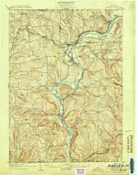
 1904 Greene1904 Print · USGSThe river valleys of Chenango and Broome counties come alive in this turn-of-the-century survey. You can trace the path of the Delaware Lackawanna and Western RR through Whitney Point or locate the early structures in Greene and Smithville Flats.6 unique versions available
 - 1904 Map of Oxford
 1904 Oxford1904 Print · USGSChenango County communities thrive along the river and rail corridors of the early twentieth century. Researchers can trace family homesteads near Oxford, locate Robinson Mill, or follow the routes of the New York Ontario and Western RR.5 unique versions available
 - 1905 Map of Nineveh
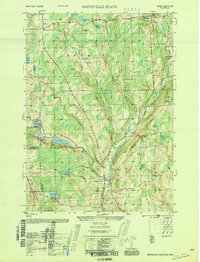
 1905 Nineveh1905 Print · USGSBroome County at the turn of the century shows a landscape dominated by the winding Susquehanna River and vital rail corridors. Genealogists can trace early homesteads and hamlets from Vallonia Springs to Center Village, alongside the path of the Delaware and Hudson railroad.6 unique versions available
 - 1935 Map of Chenango Forks
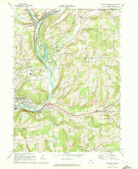
 1935 Chenango Forks1935 Print · USGSThe river valleys and rail corridors of Broome County come alive in this mid-1930s survey of the Chenango Forks area. Genealogists can trace rural life through a network of local institutions like West Colesville Ch, Oak Hill Sch, and the C C C Camp.
 - 1942 Map of Chenango Forks
 1942 Chenango Forks1942 Print · USGSUpper Broome County in the years before the war shows a landscape shaped by river junctions and burgeoning state park development. Local historians can trace early school districts and railroad routes through Chenango Forks, Sanitaria Springs, and the CCC Camp at Chenango Valley State Park.3 unique versions available
 - 1948 Map of Greene, 1968 Print
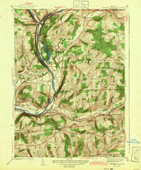
 1948 Greene1968 Print · USGSChenango County is captured here in the years following the war, showing the river-and-rail economy of the central valley. Genealogists and local historians can trace the Catskill Turnpike, find the Greene Landing Field, and locate family plots at Barnes Cem and Eliot Cem.
 - 1948 Map of Smithville Flats, 1968 Print
 1948 Smithville Flats1968 Print · USGSChenango County's rural heartland is captured here in the late 1940s, showing a landscape defined by creek-side villages and upland farmsteads. Researchers can trace ancestral lines through family-named sites like Knickerbocker Cem, Wilcox Corners, and the historic schoolhouse at Mariams Sch.3 unique versions available
 - 1948 Map of Binghamton, 1980 Print
 1948 Binghamton1980 Print · USGSCentral New York and the Southern Tier thrive in the late 1940s as a hub of rail traffic and mountain industry. Researchers can trace historic transit lines like the Erie Railroad through Binghamton or find old valley settlements near Oneonta and Delhi.
 - 1949 Map of Tyner, 1963 Print
 1949 Tyner1963 Print · USGSChenango County's upland ridges and river valleys are captured here in the late 1940s as rural life centered on small corners and rail stops. You can trace the Abandoned Canal along the Chenango River or locate family burial sites like Loomis Cem and Moore Cem.3 unique versions available
 - 1949 Map of Brisben, 1964 Print
 1949 Brisben1964 Print · USGSChenango County in the late 1940s remains a landscape of river-valley rail lines and high-ridge farms. Family historians can trace local roots through landmarks like the Little White Ch, Old Chapel Cem, and rural schoolhouses such as School No 24.2 unique versions available
 - 1950 Map of Greene
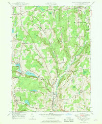
 1950 Greene1950 Print · USGSThe Chenango River valley in the years after the war shows a landscape of rail-connected villages and historic turnpikes. Genealogists can locate family burial sites at Sylvan Lawn Cem and Horton Cem or trace the path of the Catskill Turnpike.
 - 1950 Map of Binghamton
 1950 Binghamton1950 Print · USGSBinghamton and the surrounding Southern Tier are shown in the mid-century era, highlighting the intricate rail and river networks that drove local industry. Researchers can trace the path of the Erie Railroad and locate landmarks from Otsego Lake to Sidney Mountain.2 unique versions available
 - 1950 Map of Smithville Flats
 1950 Smithville Flats1950 Print · USGSMid-century Chenango County remains a landscape of dairy farms and small hamlets before modern development altered the rural character. Trace ancestral roots at Westview Cem, locate vanished schoolhouses like School No 1, and explore the banks of Genegantslet Creek.
 - 1950 Map of Chenango Forks, 1951 Print
 1950 Chenango Forks1951 Print · USGSThe river valleys and rail lines north of Binghamton converge here at the start of the 1950s. Genealogists and local historians can trace the rural school system from School No 29 to School No 5, or follow the rail-era growth of Port Crane and Sanitaria Springs.
 - 1951 Map of Brisben
 1951 Brisben1951 Print · USGSChenango County's river-and-rail corridor is captured here at mid-century, following the valley through the town of Oxford. Researchers can locate vanished landmarks like the Abandoned Canal, Old Chapel Ch, and rural schoolhouses including School No 24.
 - 1951 Map of Tyner
 1951 Tyner1951 Print · USGSThe Chenango River valley in the early fifties shows a landscape of rural hamlets and deep-rooted family history. You can trace the path of the Abandoned Canal and find numerous family-named burial sites like Moore Cem and Bowles Cem.
 - 1957 Map of Belden, 1959 Print
 1957 Belden1959 Print · USGSBroome County’s rural landscapes are captured here during the late fifties, showing a region shaped by the Delaware and Hudson railroad. Researchers can locate several family-history landmarks, including New Ohio Cem, Pratts Cem, and the village of Harpursville near the Susquehanna River.
 - 1958 Map of Binghamton
 1958 Binghamton1958 Print · USGSCentral New York in the late fifties was a network of manufacturing cities and river valleys connected by vital rail lines. Genealogists and historians can trace family roots in Oneonta, Norwich, and Cooperstown or locate long-standing farms along Schoharie Creek.
 - 1960 Map of Chenango Forks, 1963 Print
 1960 Chenango Forks1963 Print · USGSThe river valleys of Broome County come alive in this early 1960s survey of the river confluence and the growing Chenango Valley. Genealogists and local historians can trace the foundations of Chenango Forks, the grounds of Chenango Valley State Park, and rural landmarks like Toombs Cem.
 - 1963 Map of Binghamton
 1963 Binghamton1963 Print · USGSThe Southern Tier and Catskill peaks are shown in the early sixties as new reservoirs reshaped the valleys. Trace historic rail corridors like the Erie Lackawanna RR and explore lakeside settlements such as Cooperstown and Oneonta.
 - 1968 Map of Chenango Forks, 1972 Print
 1968 Chenango Forks1972 Print · USGSBroome County at the end of the sixties reveals a landscape shaped by river confluences and the expansion of the regional rail network. Genealogists and local historians can trace family markers at Toombs Cem, explore the early footprint of Port Crane, and locate the Chenango Bridge Landing Field.2 unique versions available
 - 1985 Map of Binghamton, 1986 Print
 1985 Binghamton1986 Print · USGSThe Southern Tier during the mid-1980s shows a landscape of river-valley industry and expanding university campuses. Genealogists and local historians can trace family roots through riverside towns like Bainbridge, Sidney, and the Calvary Cem in the Binghamton area.2 unique versions available
 - 2010 Map of Chenango Forks, 2010 Print
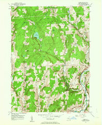
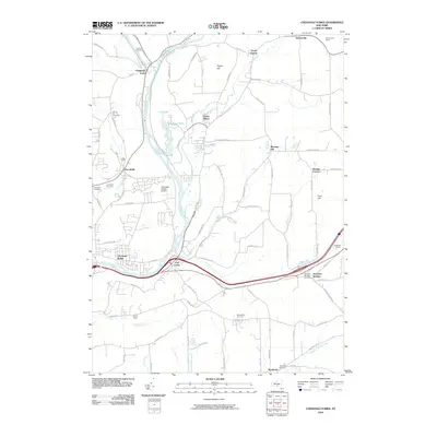 2010 Chenango Forks2010 Print · USGSCovers Greene, including Chenango, Fenton, and other nearby areas
Showing maps 1-25 of 54
Top cities near Greene
- Union historical maps
- Binghamton historical maps
- Vestal historical maps
- Johnson City historical maps
- Chenango historical maps
- Fenton historical maps
See more
Top neighborhoods of Greene
- Fickles Corner historical maps
- Page Brook historical maps
- Brisben historical maps
- Genegantslet historical maps
- Lower Genegantslet Corner historical maps
- Greene historical maps
Frequently asked questions
- What are the different types of historical maps available for Greene?
- What is the oldest map of Greene?
- Where can I purchase historical maps of Greene for my home or office?
- Where can I download high-res historical maps of Greene?
- Are there historical topographic maps available for Greene?
- Is there historical aerial imagery available for Greene?
- Where are historical maps of Greene sourced from?