1940s Maps of Oxford, New York
Explore 5 historic maps of Oxford from the 1940s. These maps offer a rare glimpse into what life looked like during the 1940s — showing old roads, neighborhoods, homes, and landmarks that have changed or disappeared over time.
Whether you're researching your family's past, planning a metal detecting trip, or studying how Oxford's landscape evolved across the 1940s, these high-resolution maps are a powerful tool for exploring the history of this region.
- Focus on a specific era: All maps on this page are from the 1940s, giving you a focused view of this time period.
- See what’s changed: Compare century-old streets, trails, and buildings to today's modern landscape using overlays and satellite layers.
- Research with precision: Use these maps for genealogy, historical research, land use analysis, or educational projects.
- View, download, or print: Maps are fully viewable online in high resolution, and can be downloaded or printed for your own records.
Start exploring Oxford's history through authentic maps from the 1940s. This is your window into the past.
Oxford, NY maps
(5)- 1948 Map of Binghamton, 1980 Print
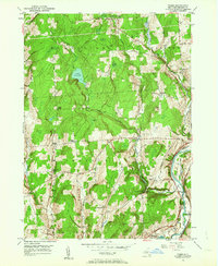
 1948 Binghamton1980 Print · USGSCentral New York and the Southern Tier thrive in the late 1940s as a hub of rail traffic and mountain industry. Researchers can trace historic transit lines like the Erie Railroad through Binghamton or find old valley settlements near Oneonta and Delhi.
 - 1949 Map of Tyner, 1963 Print
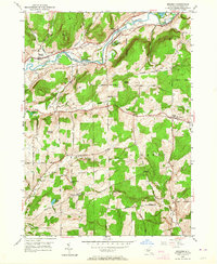
 1949 Tyner1963 Print · USGSChenango County's upland ridges and river valleys are captured here in the late 1940s as rural life centered on small corners and rail stops. You can trace the Abandoned Canal along the Chenango River or locate family burial sites like Loomis Cem and Moore Cem.3 unique versions available
 - 1949 Map of Brisben, 1964 Print
 1949 Brisben1964 Print · USGSChenango County in the late 1940s remains a landscape of river-valley rail lines and high-ridge farms. Family historians can trace local roots through landmarks like the Little White Ch, Old Chapel Cem, and rural schoolhouses such as School No 24.2 unique versions available
 - 1949 Map of Oxford, 1967 Print
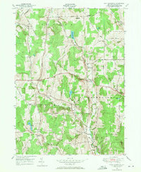
 1949 Oxford1967 Print · USGSChenango River valley life in the late 1940s centers on the busy rail and river hub of Oxford. Trace the transition from water to rail travel along the Abandoned Canal and find local landmarks like the Womans Relief Corps Home and Gospel Hill Ch.
 - 1949 Map of West Bainbridge, 1971 Print
 1949 West Bainbridge1971 Print · USGSChenango County upland territory is documented here just after the war, showing the rural townships of Bainbridge and Coventry. Researchers can trace ancestral property and travel routes through old settlements like Coventryville, North Afton, and the West Bainbridge Cemetery.2 unique versions available
End of results
Showing maps 1-5 of 5
Top cities near Oxford
- Norwich historical maps
- Fenton historical maps
- Sidney historical maps
- Greene historical maps
- Colesville historical maps
- Unadilla historical maps
See more
Top neighborhoods of Oxford
Frequently asked questions
- What are the different types of historical maps available for Oxford?
- What is the oldest map of Oxford?
- Where can I purchase historical maps of Oxford for my home or office?
- Where can I download high-res historical maps of Oxford?
- Are there historical topographic maps available for Oxford?
- Is there historical aerial imagery available for Oxford?
- Where are historical maps of Oxford sourced from?