1950s Maps of Columbia County, New York
Explore 18 historic maps of Columbia County from the 1950s. These maps offer a rare glimpse into what life looked like during the 1950s — showing old roads, neighborhoods, homes, and landmarks that have changed or disappeared over time.
Whether you're researching your family's past, planning a metal detecting trip, or studying how Columbia County's landscape evolved across the 1950s, these high-resolution maps are a powerful tool for exploring the history of this region.
- Focus on a specific era: All maps on this page are from the 1950s, giving you a focused view of this time period.
- See what’s changed: Compare century-old streets, trails, and buildings to today's modern landscape using overlays and satellite layers.
- Research with precision: Use these maps for genealogy, historical research, land use analysis, or educational projects.
- View, download, or print: Maps are fully viewable online in high resolution, and can be downloaded or printed for your own records.
Start exploring Columbia County's history through authentic maps from the 1950s. This is your window into the past.
Columbia County, NY maps
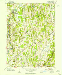
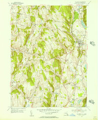
(18)- 1950 Map of Egremont
 1950 Egremont1950 Print · USGSThe Berkshires of the mid-twentieth century are captured here along the New York border, showing the rural character of the Egremont hamlets. Researchers can trace historic property lines near Egremont Plain or locate old landmarks like the Great Barrington Airport and Prospect Lake.
 - 1953 Map of Stottville, 1955 Print
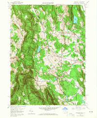
 1953 Stottville1955 Print · USGSColumbia County at mid-century reveals a landscape shaped by early American history and the valley's industrial waterways. Genealogists and historians can trace family roots through the Martin Van Buren Homestead, the Ichabod Crane Home, and landmarks like Brick Tavern.3 unique versions available
 - 1953 Map of Ravena, 1955 Print
 1953 Ravena1955 Print · USGSThe Hudson River valley at the dawn of the interstate era shows a landscape where historic riverfront villages meet modern infrastructure. Trace the early New York State Thruway past sites like Schodack Landing, Deans Mill, and Waldron Cem.3 unique versions available
 - 1953 Map of Kinderhook, 1955 Print
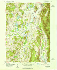
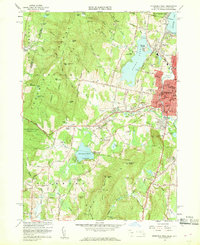
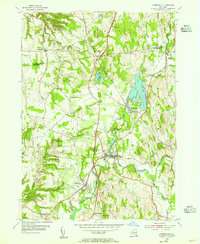 1953 Kinderhook1955 Print · USGSColumbia County in the early fifties shows a landscape of established villages and working waterways at the height of the rail era. Genealogists can trace family footprints near the House of History, Kinderhook Lake, and Muitzes Kill.2 unique versions available
 - 1953 Map of East Chatham, 1955 Print
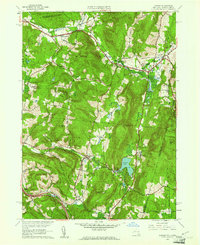
 1953 East Chatham1955 Print · USGSColumbia County’s rural landscape is preserved in this mid-century survey as the New York Central railroad still wound through the valley. Researchers can trace ancestral roots at The Maples Cem or locate the Shaker Museum and Riders Mills Sch in their original settings.3 unique versions available
 - 1953 Map of Hudson North, 1955 Print
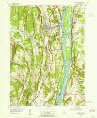
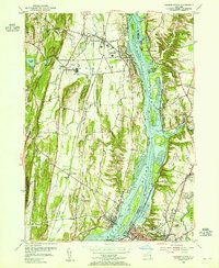 1953 Hudson North1955 Print · USGSThe Hudson Valley in the early fifties shows a landscape defined by its riverfront industry and deep-rooted settlements. Genealogists and local historians can trace family locations near Riverside Cem, the Rossman Sch, or the historic docks of Athens and Newton Hook.3 unique versions available
 - 1953 Map of Copake, 1955 Print
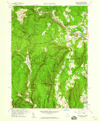
 1953 Copake1955 Print · USGSColumbia County at the dawn of the fifties shows a landscape of rail-connected hamlets and highland parks. Researchers can trace the old rail lines through Boston Corner and Whitehouse Crossing or locate family roots near West Copake Ch.4 unique versions available
 - 1953 Map of Chatham, 1955 Print
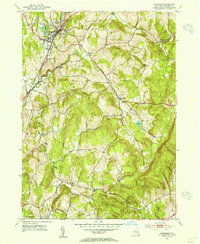 1953 Chatham1955 Print · USGSColumbia County in the early fifties shows a transition from rail-dependent industry to a quiet rural landscape. Genealogists can locate family landmarks like Arnolds Mill, Moorhouse Corner, and the German Cem near Harlemville.5 unique versions available
 - 1953 Map of Hillsdale, 1955 Print
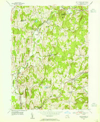
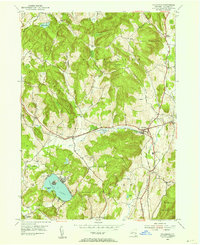 1953 Hillsdale1955 Print · USGSColumbia County at the mid-century reveals a landscape of high ridges and railroad-centered hamlets like Craryville and Hillsdale. Genealogists and local historians can trace the New York Central line and find rural landmarks like Drum Church and Williams Cem.3 unique versions available
 - 1955 Map of Millerton, 1957 Print
 1955 Millerton1957 Print · USGSThe borderlands of New York and Connecticut appear here in the mid-1950s, showing a landscape defined by dairy farms and railroad junctions. Genealogists and local historians can trace the New York Central line through stops like Coleman Station and Sharon Station, or locate family sites at Irondale Cem and Bryan Cem.4 unique versions available
 - 1956 Map of Albany, 1968 Print
 1956 Albany1968 Print · USGSThe industrial heart of the Northeast is revealed in the mid-1950s, from the Hudson Valley to the Connecticut River. Researchers can trace the legacy of the Quabbin Reservoir, locate Westover Air Force Base, or follow the Rutland RR through the Green Mountains.2 unique versions available
 - 1957 Map of Albany
 1957 Albany1957 Print · USGSThe Tri-State region and Connecticut River Valley are captured here during a period of significant postwar growth and infrastructure expansion. Genealogists and historians can trace the rail-and-river economy through landmarks like the Boston and Maine railroad, Quabbin Reservoir, and Westover Air Force Base.
 - 1958 Map of Bashbish Falls, 1959 Print
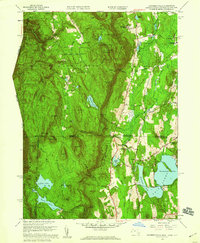 1958 Bashbish Falls1959 Print · USGSThe tri-state border of the Taconics is captured here during the late 1950s, showing the intersection of wilderness and mountain settlement. Genealogists and hikers can trace the Appalachian Trail past Churchill Cem and the small village of Joyceville.8 unique versions available
 - 1958 Map of Egremont, 1965 Print
 1958 Egremont1965 Print · USGSThe Berkshire highlands come to life in this mid-century survey of the New York-Massachusetts border. Genealogists and historians can trace the foundations of Alford, locate the Battlesite Mon, and find family plots at Riverside Cem and Dartmouth Cem.2 unique versions available
 - 1959 Map of Albany
 1959 Albany1959 Print · USGSThe Hudson and Connecticut River valleys are captured here during the late fifties, showing the region's dense rail networks and massive water projects. Researchers can trace the New York State Thruway or locate local landmarks like Mt Greylock and the Quabbin Reservoir.
 - 1959 Map of State Line, 1960 Print
 1959 State Line1960 Print · USGSThe New York and Massachusetts borderlands are captured here in the late fifties as modern toll roads began to reshape the old mining landscape. Genealogists and historians can trace the foundations of Richmond Furnace, old burial grounds like Austerlitz Cem, and the path of the New York Central railroad.2 unique versions available
 - 1959 Map of Pittsfield West, 1960 Print
 1959 Pittsfield West1960 Print · USGSThe eastern Berkshires and the city of Pittsfield appear here in the late fifties as urban growth reaches toward the Taconic Range. Researchers can trace local heritage through sites like Shaker Village, the New York Central tracks, and family plots in St Josephs Cemetery.2 unique versions available
 - 1959 Map of Canaan, 1961 Print
 1959 Canaan1961 Print · USGSThe borderlands of New York and Massachusetts are captured here in the late fifties as rural life centered on the valleys of Canaan and New Lebanon. Genealogists and historians can trace the Cemetery of the Evergreens or the grounds of Mt Lebanon Darrow Sch.2 unique versions available
End of results
Showing maps 1-18 of 18
Top cities of Columbia County
- Kinderhook historical maps
- Claverack historical maps
- Hudson historical maps
- Ghent historical maps
- Greenport historical maps
- Chatham historical maps
See more
Frequently asked questions
- What are the different types of historical maps available for Columbia County?
- What is the oldest map of Columbia County?
- Where can I purchase historical maps of Columbia County for my home or office?
- Where can I download high-res historical maps of Columbia County?
- Are there historical topographic maps available for Columbia County?
- Is there historical aerial imagery available for Columbia County?
- Where are historical maps of Columbia County sourced from?