1980s Maps of Columbia County, New York
Explore 13 historic maps of Columbia County from the 1980s. These maps offer a rare glimpse into what life looked like during the 1980s — showing old roads, neighborhoods, homes, and landmarks that have changed or disappeared over time.
Whether you're researching your family's past, planning a metal detecting trip, or studying how Columbia County's landscape evolved across the 1980s, these high-resolution maps are a powerful tool for exploring the history of this region.
- Focus on a specific era: All maps on this page are from the 1980s, giving you a focused view of this time period.
- See what’s changed: Compare century-old streets, trails, and buildings to today's modern landscape using overlays and satellite layers.
- Research with precision: Use these maps for genealogy, historical research, land use analysis, or educational projects.
- View, download, or print: Maps are fully viewable online in high resolution, and can be downloaded or printed for your own records.
Start exploring Columbia County's history through authentic maps from the 1980s. This is your window into the past.
Columbia County, NY maps
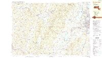
(13)- 1980 Map of Kinderhook, 1981 Print
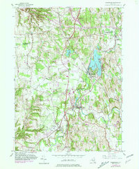 1980 Kinderhook1981 Print · USGSColumbia County in the early eighties retains its storied village character even as modern parkways and rail lines intersect the landscape. Genealogists can trace family footprints near Kinderhook at the House of History or locate early settlements along the Valatie Kill.
 - 1980 Map of Hillsdale, 1981 Print
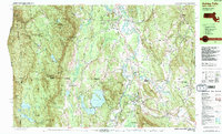
 1980 Hillsdale1981 Print · USGSThe hills of Columbia County are captured here in the early eighties, showing a landscape defined by dairy country and growing summer retreats. Genealogists can locate family-named sites like Crum Cem and Collins Cem, or trace the New York Central rail line.
 - 1980 Map of Hudson South, 1981 Print
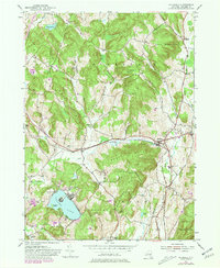
 1980 Hudson South1981 Print · USGSThe Hudson River valley at the start of the 1980s reveals a blend of historic estates, maritime industry, and established river towns. Genealogists and historians can trace riverside landings and local institutions like Olana Historic Site, St Anthonys Seminary, and the Germantown Reformed Cemetery.
 - 1980 Map of Hudson North, 1981 Print
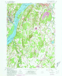
 1980 Hudson North1981 Print · USGSThe Hudson River valley at the dawn of the 1980s reveals a landscape of industrial river towns and sprawling institutions. Genealogists and historians can trace family sites at Limestreet Cem or explore the rail-linked history of Stockport Sta and Newton Hook.
 - 1985 Map of Waterbury, 1986 Print
 1985 Waterbury1986 Print · USGSThe Western Connecticut highlands and the Hudson Valley are captured in the mid-1980s, showing a landscape of deep forests and industrial river towns. Genealogists can trace family connections from Waterbury up through Litchfield and Torrington, while exploring the vast Barkhamsted Reservoir and Candlewood Lake basins.
 - 1986 Map of Albany
 1986 Albany1986 Print · USGSThe Capital District and the tri-state highlands come into focus during the mid-eighties as urban growth meets the edge of the Green Mountains. Researchers can trace historic industrial sites and landmarks like the Watervliet Arsenal, the Bennington Battle Monument, and the grounds of Rensselaer Polytechnic Institute.
 - 1986 Map of Pittsfield
 1986 Pittsfield1986 Print · USGSThe Berkshires and the Hudson Valley meet in the mid-1980s, documenting a cross-border landscape of mountain forests and river towns. Genealogists and historians can trace the paths of Conrail and the Taconic State Parkway as they pass through Stockbridge, Great Barrington, and Kinderhook.2 unique versions available
 - 1987 Map of Ashley Falls
 1987 Ashley Falls1987 Print · USGSThe tri-state border region of the Berkshires comes to life in the late eighties, showing the deep valleys of the Housatonic River and the high ridges of the Mount Washington State Forest. Genealogists and hikers can trace the Appalachian Trail past Mt Everett or locate local landmarks like Union Ch and the historic settlement of Sodom.2 unique versions available
 - 1987 Map of Stockbridge
 1987 Stockbridge1987 Print · USGSThe Berkshires of the late eighties are documented here, featuring the cultural corridor between Stockbridge and Lenox. Researchers can trace the grounds of Tanglewood Auditorium, family plots in Stockbridge Cem, and early industry at Richmond Furnace.2 unique versions available
 - 1987 Map of Great Barrington, 1988 Print
 1987 Great Barrington1988 Print · USGSThe Berkshires in the late eighties show a sophisticated blend of town life and conservation, centered on the Housatonic River valley. Genealogists and local researchers can pinpoint historical landmarks like the Battlesite Mon, the Simons Rock Early College campus, and local neighborhoods such as Berkshire Heights.
 - 1988 Map of Pittsfield West
 1988 Pittsfield West1988 Print · USGSThe Massachusetts-New York state line runs through the Taconic Range in the late eighties, where the urban expansion of Pittsfield meets rural Berkshire landscapes. Researchers can trace historic cemeteries and schools alongside recreation sites like Lebanon Valley Speedway and Richmond Pond.2 unique versions available
 - 1988 Map of Stephentown Center
 1988 Stephentown Center1988 Print · USGSThe Rensselaer and Berkshire county borderlands appear here in the late eighties, just as traditional valley hamlets met the expansion of mountain recreation. Genealogists and local historians can locate many family sites, including St Josephs Cem, Hancock Cem, and the Hancock Central Sch.
 - 1989 Map of Albany
 1989 Albany1989 Print · USGSThe tri-state intersection of New York, Vermont, and Massachusetts comes alive in the late 1980s, centered on the historic river confluence of the Capital District. Researchers can trace the extensive rail lines of the D & H RR and explore high peaks like Mount Greylock or the reaches of the Tomhannock Reservoir.2 unique versions available
End of results
Showing maps 1-13 of 13
Top cities of Columbia County
- Kinderhook historical maps
- Claverack historical maps
- Hudson historical maps
- Ghent historical maps
- Greenport historical maps
- Chatham historical maps
See more
Frequently asked questions
- What are the different types of historical maps available for Columbia County?
- What is the oldest map of Columbia County?
- Where can I purchase historical maps of Columbia County for my home or office?
- Where can I download high-res historical maps of Columbia County?
- Are there historical topographic maps available for Columbia County?
- Is there historical aerial imagery available for Columbia County?
- Where are historical maps of Columbia County sourced from?