1960s Maps of Columbia County, New York
Explore 12 historic maps of Columbia County from the 1960s. These maps offer a rare glimpse into what life looked like during the 1960s — showing old roads, neighborhoods, homes, and landmarks that have changed or disappeared over time.
Whether you're researching your family's past, planning a metal detecting trip, or studying how Columbia County's landscape evolved across the 1960s, these high-resolution maps are a powerful tool for exploring the history of this region.
- Focus on a specific era: All maps on this page are from the 1960s, giving you a focused view of this time period.
- See what’s changed: Compare century-old streets, trails, and buildings to today's modern landscape using overlays and satellite layers.
- Research with precision: Use these maps for genealogy, historical research, land use analysis, or educational projects.
- View, download, or print: Maps are fully viewable online in high resolution, and can be downloaded or printed for your own records.
Start exploring Columbia County's history through authentic maps from the 1960s. This is your window into the past.
Columbia County, NY maps
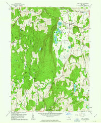
(12)- 1960 Map of Ancram, 1962 Print
 1960 Ancram1962 Print · USGSColumbia and Dutchess County rural life is detailed here as it stood in the early sixties, centered on the historic settlements and waterways of the Hudson Highlands. Genealogists and historians can trace family locations near Ancram Union Cem or locate old industrial sites like Spaulding Furnace and New Forge.4 unique versions available
 - 1960 Map of Claverack, 1962 Print
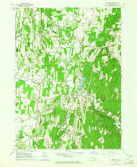
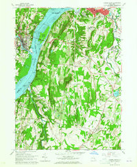
 1960 Claverack1962 Print · USGSColumbia County at the dawn of the sixties shows a landscape where historic mill villages meet the modern sweep of the parkway. Genealogists and historians can trace family locations near Churchtown, Philmont, and the rural School No 7 and Trinity Ch.4 unique versions available
 - 1960 Map of Pine Plains, 1963 Print
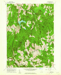
 1960 Pine Plains1963 Print · USGSNorthern Dutchess County remains a landscape of glacial lakes and mountain ridges in the early sixties. Genealogists and local historians can trace family-named sites like Conklin Hill or locate the Church of the Regeneration and Evergreen Cem in Pine Plains.4 unique versions available
 - 1960 Map of Hancock, 1966 Print
 1960 Hancock1966 Print · USGSThe Massachusetts-New York borderlands are surveyed here in the early sixties, showing the mountain hollows and rural cross-border communities of the Taconics. Genealogists can locate several family cemeteries and historical landmarks like the Whitman Burial Vault, Hancock Central Sch, and St Josephs Cem.
 - 1961 Map of Hartford
 1961 Hartford1961 Print · USGSSouthern New England and the Hudson Valley are shown here in the mid-fifties, capturing a landscape of booming coastal cities and interior hill towns. Researchers can trace the legacy of the New York New Haven and Hartford rail corridor and find strategic sites like Camp Shanks and Fort Michie.
 - 1962 Map of Albany
 1962 Albany1962 Print · USGSThe Hudson and Connecticut River valleys meet the Green Mountains and Berkshires in this mid-century overview of the Northeast. Genealogists and historians can trace the industrial hearts of Albany and Springfield or locate features like Quabbin Reservoir and Westover Air Force Base.
 - 1962 Map of Hartford, 1971 Print
 1962 Hartford1971 Print · USGSSouthern New England and the Hudson Valley are shown in the early sixties, as suburban growth reached into the foothills. Trace the path of the New York New Haven & Hartford RR and find landmarks like Camp Nathan Hale and Gillette Castle State Park.3 unique versions available
 - 1963 Map of Clermont, 1964 Print
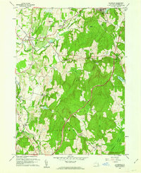
 1963 Clermont1964 Print · USGSThe Columbia and Dutchess County line comes to life in the early sixties as a region of winding kills and crossroads hamlets. Genealogists and historians can trace family-named sites like Bingham Mills, Cokertown, and St Johns Ch.4 unique versions available
 - 1963 Map of Hudson South, 1965 Print
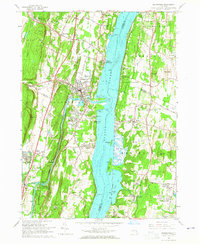
 1963 Hudson South1965 Print · USGSThe Hudson River Valley in the early sixties showcases a bustling corridor of industry and education between Hudson and Catskill. Researchers can trace the river's influence on local growth through the Rip Van Winkle Bridge, the State School for Girls, and the tracks of the New York Central Railroad.3 unique versions available
 - 1963 Map of Saugerties, 1965 Print
 1963 Saugerties1965 Print · USGSThe Hudson River waterfront near Saugerties is captured here in the early 1960s, showing a landscape of historic estates and river-oriented industry. Genealogists can trace family sites in Malden-on-Hudson, locate the Birthplace of Robert Livingston, or find St Marys Ch.5 unique versions available
 - 1963 Map of Cementon, 1965 Print
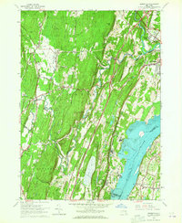 1963 Cementon1965 Print · USGSThe Hudson Valley in the early sixties reveals a landscape of industrial river towns and mountain-edge settlements. Researchers can trace the riverfront rail economy through Cementon and Alsen or locate historic landmarks like Kiskatom Ch and the Old Kings Road.4 unique versions available
 - 1965 Map of Hartford
 1965 Hartford1965 Print · USGSSouthern New England and the Hudson Valley are shown here during the mid-sixties expansion of the Interstate era. Trace the path of the New York New Haven & Hartford RR or locate historic landmarks like West Point Military Reservation and the Merritt Parkway.2 unique versions available
End of results
Showing maps 1-12 of 12
Top cities of Columbia County
- Kinderhook historical maps
- Claverack historical maps
- Hudson historical maps
- Ghent historical maps
- Greenport historical maps
- Chatham historical maps
See more
Frequently asked questions
- What are the different types of historical maps available for Columbia County?
- What is the oldest map of Columbia County?
- Where can I purchase historical maps of Columbia County for my home or office?
- Where can I download high-res historical maps of Columbia County?
- Are there historical topographic maps available for Columbia County?
- Is there historical aerial imagery available for Columbia County?
- Where are historical maps of Columbia County sourced from?