1900s (20th Century) Maps of Ancram, New York
Explore 30 historic maps of Ancram from the 1900s (20th Century). These maps offer a rare glimpse into what life looked like during the 1900s — showing old roads, neighborhoods, homes, and landmarks that have changed or disappeared over time.
Whether you're researching your family's past, planning a metal detecting trip, or studying how Ancram's landscape evolved across the 1900s, these high-resolution maps are a powerful tool for exploring the history of this region.
- Focus on a specific era: All maps on this page are from the 1900s, giving you a focused view of this time period.
- See what’s changed: Compare century-old streets, trails, and buildings to today's modern landscape using overlays and satellite layers.
- Research with precision: Use these maps for genealogy, historical research, land use analysis, or educational projects.
- View, download, or print: Maps are fully viewable online in high resolution, and can be downloaded or printed for your own records.
Start exploring Ancram's history through authentic maps from the 1900s. This is your window into the past.
Ancram, NY maps
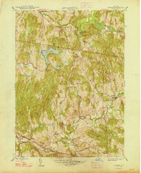
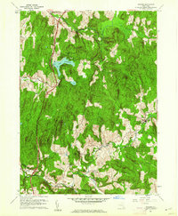
(30)- 1900 Map of Housatonic
 1900 Housatonic1900 Print · USGSThe Berkshires and the Housatonic Valley are captured here at a moment of industrial and social transition during the late Victorian era. Genealogists and historians can trace the early rail networks of the Boston and Albany R.R. through old settlements like Shaker Village and Lenox Furnace.5 unique versions available
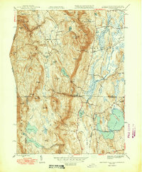
 - 1902 Map of Millbrook
 1902 Millbrook1902 Print · USGSEastern Dutchess County at the turn of the century was a bustling corridor of intersecting railroads and valley settlements. Genealogists and rail historians can trace the paths of the Central New England R. R. and find local landmarks like Lithgow, Shekomeko, and Hammertown.10 unique versions available
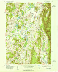
 - 1902 Map of Copake, 1954 Print
 1902 Copake1954 Print · USGSColumbia County at the turn of the century shows a landscape defined by industry and iron, before modern highways bypassed these hillside hamlets. Trace the rail-and-mine economy through Copake Ironworks, the Weed Mines, and the busy junction at Boston Corners.
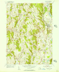
 - 1904 Map of Copake
 1904 Copake1904 Print · USGSColumbia County at the turn of the century shows a landscape defined by deep-rooted industry and an extensive rail network. Researchers can trace the legacy of mining and milling at Ancram Leadmines, Weed Mines, and the Spaulding Furnace along the Roeliff Jansen Kill.7 unique versions available
 - 1943 Map of Housatonic
 1943 Housatonic1943 Print · USGSThe Berkshires and the Housatonic Valley are captured during the war years, showing a landscape of traditional Shaker settlements and growing industrial centers. Trace the routes of the NY NH & H RR and explore sites like Shaker Village, Richmond Furnace, and Rockdale Mills.
 - 1947 Map of Hartford, 1955 Print
 1947 Hartford1955 Print · USGSSouthern New England and the Hudson Valley are shown in detail during the post-war expansion era. Genealogists and researchers can trace local landmarks from the State Capitol and Yale University to the Stratford Lighthouse and Woodlawn Cem.2 unique versions available
 - 1948 Map of Ancram
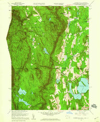
 1948 Ancram1948 Print · USGSColumbia County in the late 1940s remained a landscape of dispersed hamlets and rural school districts. Researchers can trace historic industry at Spaulding Furnace and locate family landmarks like Vedder Ch, Silvernails, and New Forge.2 unique versions available
 - 1948 Map of Hartford
 1948 Hartford1948 Print · USGSSouthern New England is captured here in the late 1940s, showcasing a landscape of thriving industrial cities and developing parkways. Genealogists and historians can trace the rail networks of the New York New Haven and Hartford RR or locate coastal defense sites like Fort Terry and Camp Shanks.2 unique versions available
 - 1948 Map of Pine Plains
 1948 Pine Plains1948 Print · USGSMid-century Dutchess County is captured here in a moment of quiet transition, showing the rural landscape before modern development. Genealogists can locate family-named landmarks like Pachin Mills, Old Attlebury, and rural schoolhouses such as Bear Market Sch.
 - 1948 Map of Bashbish Falls
 1948 Bashbish Falls1948 Print · USGSThe Berkshires and Taconic Mountains meet in the late 1940s at this rare intersection of three state borders. Follow the original route of the Appalachian Trail past Bashbish Falls, Mt Everett, and Twin Lakes.
 - 1948 Map of Albany, 1951 Print
 1948 Albany1951 Print · USGSThe Hudson and Connecticut River valleys are captured here in the late 1940s, showing the vital rail and water corridors of the Northeast. You can trace the Boston and Maine tracks past Mt Greylock or locate early settlements like Great Barrington and Bennington.
 - 1949 Map of Bashbish Falls
 1949 Bashbish Falls1949 Print · USGSThe Berkshires and the Litchfield Hills meet in the late 1940s at this rare tri-state intersection of Massachusetts, Connecticut, and New York. Local historians can trace the Appalachian Trail across Mt Everett or locate the Churchill Cem and Berkshire Sch near the town of Salisbury.2 unique versions available
 - 1953 Map of Copake, 1955 Print
 1953 Copake1955 Print · USGSColumbia County at the dawn of the fifties shows a landscape of rail-connected hamlets and highland parks. Researchers can trace the old rail lines through Boston Corner and Whitehouse Crossing or locate family roots near West Copake Ch.4 unique versions available
 - 1955 Map of Millerton, 1957 Print
 1955 Millerton1957 Print · USGSThe borderlands of New York and Connecticut appear here in the mid-1950s, showing a landscape defined by dairy farms and railroad junctions. Genealogists and local historians can trace the New York Central line through stops like Coleman Station and Sharon Station, or locate family sites at Irondale Cem and Bryan Cem.4 unique versions available
 - 1956 Map of Albany, 1968 Print
 1956 Albany1968 Print · USGSThe industrial heart of the Northeast is revealed in the mid-1950s, from the Hudson Valley to the Connecticut River. Researchers can trace the legacy of the Quabbin Reservoir, locate Westover Air Force Base, or follow the Rutland RR through the Green Mountains.2 unique versions available
 - 1957 Map of Albany
 1957 Albany1957 Print · USGSThe Tri-State region and Connecticut River Valley are captured here during a period of significant postwar growth and infrastructure expansion. Genealogists and historians can trace the rail-and-river economy through landmarks like the Boston and Maine railroad, Quabbin Reservoir, and Westover Air Force Base.
 - 1958 Map of Bashbish Falls, 1959 Print
 1958 Bashbish Falls1959 Print · USGSThe tri-state border of the Taconics is captured here during the late 1950s, showing the intersection of wilderness and mountain settlement. Genealogists and hikers can trace the Appalachian Trail past Churchill Cem and the small village of Joyceville.8 unique versions available
 - 1959 Map of Albany
 1959 Albany1959 Print · USGSThe Hudson and Connecticut River valleys are captured here during the late fifties, showing the region's dense rail networks and massive water projects. Researchers can trace the New York State Thruway or locate local landmarks like Mt Greylock and the Quabbin Reservoir.
 - 1960 Map of Ancram, 1962 Print
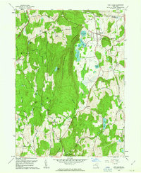
 1960 Ancram1962 Print · USGSColumbia and Dutchess County rural life is detailed here as it stood in the early sixties, centered on the historic settlements and waterways of the Hudson Highlands. Genealogists and historians can trace family locations near Ancram Union Cem or locate old industrial sites like Spaulding Furnace and New Forge.4 unique versions available
 - 1960 Map of Pine Plains, 1963 Print
 1960 Pine Plains1963 Print · USGSNorthern Dutchess County remains a landscape of glacial lakes and mountain ridges in the early sixties. Genealogists and local historians can trace family-named sites like Conklin Hill or locate the Church of the Regeneration and Evergreen Cem in Pine Plains.4 unique versions available
 - 1961 Map of Hartford
 1961 Hartford1961 Print · USGSSouthern New England and the Hudson Valley are shown here in the mid-fifties, capturing a landscape of booming coastal cities and interior hill towns. Researchers can trace the legacy of the New York New Haven and Hartford rail corridor and find strategic sites like Camp Shanks and Fort Michie.
 - 1962 Map of Albany
 1962 Albany1962 Print · USGSThe Hudson and Connecticut River valleys meet the Green Mountains and Berkshires in this mid-century overview of the Northeast. Genealogists and historians can trace the industrial hearts of Albany and Springfield or locate features like Quabbin Reservoir and Westover Air Force Base.
 - 1962 Map of Hartford, 1971 Print
 1962 Hartford1971 Print · USGSSouthern New England and the Hudson Valley are shown in the early sixties, as suburban growth reached into the foothills. Trace the path of the New York New Haven & Hartford RR and find landmarks like Camp Nathan Hale and Gillette Castle State Park.3 unique versions available
 - 1965 Map of Hartford
 1965 Hartford1965 Print · USGSSouthern New England and the Hudson Valley are shown here during the mid-sixties expansion of the Interstate era. Trace the path of the New York New Haven & Hartford RR or locate historic landmarks like West Point Military Reservation and the Merritt Parkway.2 unique versions available
 - 1975 Map of Bashbish Falls, 1981 Print
 1975 Bashbish Falls1981 Print · USGSThe tri-state border region comes into focus in the mid-1970s through this aerial orthophotograph of the Berkshires. Researchers can trace the layout of small communities like Joyceville and Taconic against the heights of Mt Everett and Bear Mtn.
Showing maps 1-25 of 30
Top cities near Ancram
- Pleasant Valley historical maps
- Great Barrington historical maps
- Claverack historical maps
- Hudson historical maps
- Ghent historical maps
- Washington historical maps
See more
Top neighborhoods of Ancram
Frequently asked questions
- What are the different types of historical maps available for Ancram?
- What is the oldest map of Ancram?
- Where can I purchase historical maps of Ancram for my home or office?
- Where can I download high-res historical maps of Ancram?
- Are there historical topographic maps available for Ancram?
- Is there historical aerial imagery available for Ancram?
- Where are historical maps of Ancram sourced from?