1950s Maps of Colden, New York
Explore 4 historic maps of Colden from the 1950s. These maps offer a rare glimpse into what life looked like during the 1950s — showing old roads, neighborhoods, homes, and landmarks that have changed or disappeared over time.
Whether you're researching your family's past, planning a metal detecting trip, or studying how Colden's landscape evolved across the 1950s, these high-resolution maps are a powerful tool for exploring the history of this region.
- Focus on a specific era: All maps on this page are from the 1950s, giving you a focused view of this time period.
- See what’s changed: Compare century-old streets, trails, and buildings to today's modern landscape using overlays and satellite layers.
- Research with precision: Use these maps for genealogy, historical research, land use analysis, or educational projects.
- View, download, or print: Maps are fully viewable online in high resolution, and can be downloaded or printed for your own records.
Start exploring Colden's history through authentic maps from the 1950s. This is your window into the past.
Colden, NY maps
(4)- 1954 Map of Springville, 1955 Print
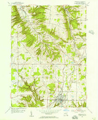 1954 Springville1955 Print · USGSSouthern Erie County in the mid-fifties is defined by the thriving village of Springville and the winding course of the Baltimore and Ohio railroad. Local historians can trace early schools and healthcare sites like Griffith Institute and Chaffee Hosp, or locate family plots at Maplewood Cem and Sibley Cem.2 unique versions available
 - 1955 Map of Holland, 1957 Print
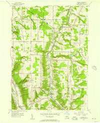
 1955 Holland1957 Print · USGSErie County's southern valleys and highlands are caught mid-century, before modern development bypassed these rural hamlets. Genealogists can trace family names at Humphrey Cem and Hunter Creek Ch, or locate the old Gow Sch near South Wales.2 unique versions available
 - 1955 Map of Colden, 1957 Print
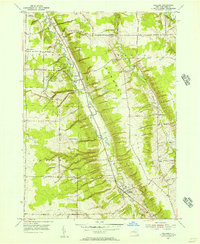
 1955 Colden1957 Print · USGSErie County in the mid-fifties shows a landscape of deep creek valleys and rising ridges connected by the Baltimore and Ohio RR. Trace the footprints of West Falls, Colden, and Patchin, or locate family sites near Maple Wood Cem and St Martins Ch.4 unique versions available
 - 1957 Map of Sardinia, 1958 Print
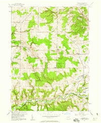 1957 Sardinia1958 Print · USGSSoutheastern Erie County in the late fifties was a landscape of high ridges and rural family crossroads. Genealogists and researchers can trace the old rail lines of the Pennsylvania Railroad and locate vanished landmarks like Tru-Blue Ch and Sillimans Corners.3 unique versions available
End of results
Showing maps 1-4 of 4
Top cities near Colden
- Buffalo historical maps
- Cheektowaga historical maps
- Hamburg historical maps
- West Seneca historical maps
- Lancaster historical maps
- Orchard Park historical maps
See more
Top neighborhoods of Colden
Frequently asked questions
- What are the different types of historical maps available for Colden?
- What is the oldest map of Colden?
- Where can I purchase historical maps of Colden for my home or office?
- Where can I download high-res historical maps of Colden?
- Are there historical topographic maps available for Colden?
- Is there historical aerial imagery available for Colden?
- Where are historical maps of Colden sourced from?