1990s Maps of Keene, New York
Explore 5 historic maps of Keene from the 1990s. These maps offer a rare glimpse into what life looked like during the 1990s — showing old roads, neighborhoods, homes, and landmarks that have changed or disappeared over time.
Whether you're researching your family's past, planning a metal detecting trip, or studying how Keene's landscape evolved across the 1990s, these high-resolution maps are a powerful tool for exploring the history of this region.
- Focus on a specific era: All maps on this page are from the 1990s, giving you a focused view of this time period.
- See what’s changed: Compare century-old streets, trails, and buildings to today's modern landscape using overlays and satellite layers.
- Research with precision: Use these maps for genealogy, historical research, land use analysis, or educational projects.
- View, download, or print: Maps are fully viewable online in high resolution, and can be downloaded or printed for your own records.
Start exploring Keene's history through authentic maps from the 1990s. This is your window into the past.
Keene, NY maps
(5)- 1999 Map of Lewis, 2000 Print
 1999 Lewis2000 Print · USGSThe eastern Adirondack wilderness meets the valley settlements of Essex County during the late twentieth century. Genealogists and local historians can trace family locations near the Boquet River, find burials at Central Cemetery, or locate the historic community of Stowersville.
 - 1999 Map of Witherbee, 2000 Print
 1999 Witherbee2000 Print · USGSThe Adirondack mining district at the close of the twentieth century shows a landscape shaped by iron and industry. Researchers can trace the Lake Champlain and Moriah Railroad as it connects Witherbee and Mineville near the Belfry Mtn Lookout Tower.
 - 1999 Map of Mount Marcy, 2001 Print
 1999 Mount Marcy2001 Print · USGSThe High Peaks of the Adirondacks are captured here at the end of the century, showing the preserved wilderness of Essex County. Backcountry researchers can trace the historic Van Hoevenberg Trail or locate remote landmarks like Tear of the Clouds and The Ice Cave.
 - 1999 Map of Keene Valley, 2001 Print
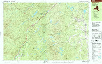
 1999 Keene Valley2001 Print · USGSThe High Peaks of the Adirondacks are captured here in the late 1990s, centering on the winter sports hub of the Mt Van Hoevenberg State Recreation Area. Researchers can locate family sites like Shaw Cem and Holt Cem or trace the historic grounds of the John Brown Farm State Historic Site.
 - 1999 Map of Lake Placid, 2001 Print
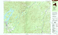 1999 Lake Placid2001 Print · USGSLake Placid at the end of the twentieth century shows a landscape defined by Olympic legacy and abolitionist history. Trace the grounds of the John Brown Farm or locate athletic landmarks like the Olympic Ski Jumps and Olympic Arena.
End of results
Showing maps 1-5 of 5
Top cities near Keene
- North Elba historical maps
- Moriah historical maps
- Jay historical maps
- Chesterfield historical maps
- Lake Placid historical maps
- Crown Point historical maps
See more
Top neighborhoods of Keene
Frequently asked questions
- What are the different types of historical maps available for Keene?
- What is the oldest map of Keene?
- Where can I purchase historical maps of Keene for my home or office?
- Where can I download high-res historical maps of Keene?
- Are there historical topographic maps available for Keene?
- Is there historical aerial imagery available for Keene?
- Where are historical maps of Keene sourced from?