1970s Maps of Keene, New York
Explore 6 historic maps of Keene from the 1970s. These maps offer a rare glimpse into what life looked like during the 1970s — showing old roads, neighborhoods, homes, and landmarks that have changed or disappeared over time.
Whether you're researching your family's past, planning a metal detecting trip, or studying how Keene's landscape evolved across the 1970s, these high-resolution maps are a powerful tool for exploring the history of this region.
- Focus on a specific era: All maps on this page are from the 1970s, giving you a focused view of this time period.
- See what’s changed: Compare century-old streets, trails, and buildings to today's modern landscape using overlays and satellite layers.
- Research with precision: Use these maps for genealogy, historical research, land use analysis, or educational projects.
- View, download, or print: Maps are fully viewable online in high resolution, and can be downloaded or printed for your own records.
Start exploring Keene's history through authentic maps from the 1970s. This is your window into the past.
Keene, NY maps
(6)- 1978 Map of Witherbee, 1979 Print
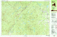 1978 Witherbee1979 Print · USGSMining and mountain life in the eastern Adirondacks intersect during the late seventies, showing the industrial pulse of these upland towns. Genealogists and hikers can trace the Lake Champlain and Moriah Railroad, find the SS Peter and Paul Cem, and locate the Belfry Mtn Lookout Tower.
 - 1978 Map of Elizabethtown, 1979 Print
 1978 Elizabethtown1979 Print · USGSElizabethtown and the Bouquet River valley are captured in the late seventies as the Adirondack Northway reshaped regional travel. Genealogists and historians can locate the Black River Cem, the Central School, and the Court House at the heart of this mountain community.2 unique versions available
 - 1978 Map of Lewbeach, 1979 Print
 1978 Lewbeach1979 Print · USGSThe High Peaks region in the late seventies reveals a landscape of high summits and small valley hamlets. Trace the family names of Stowersville and Deerhead, or locate the Central Cemetery and the Covered Bridge along the Ausable River East Branch.
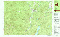
 - 1979 Map of Keene Valley
 1979 Keene Valley1979 Print · USGSThe High Peaks region during the late seventies reveals a landscape prepared for world-class competition. Trace family sites at Norton Cem and Olympic history at the Luge Run or Mt Van Hoevenberg Recreational Center.2 unique versions available
 - 1979 Map of Lake Placid
 1979 Lake Placid1979 Print · USGSThe Lake Placid region in the late seventies reveals a landscape on the verge of the Winter Games. Trace the development of Olympic venues like the Olympic Arena and 90-meter Tower alongside local landmarks like John Browns Grave.
 - 1979 Map of Mount Marcy
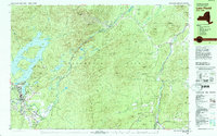
 1979 Mount Marcy1979 Print · USGSThe High Peaks wilderness is captured in the late seventies, showing the intricate trail and waterway systems surrounding the state's highest point. Hikers and historians can trace routes like the Guide Board Trail or locate remote spots like Marcy Landing and the Boreas Ponds.
End of results
Showing maps 1-6 of 6
Top cities near Keene
- North Elba historical maps
- Moriah historical maps
- Jay historical maps
- Chesterfield historical maps
- Lake Placid historical maps
- Crown Point historical maps
See more
Top neighborhoods of Keene
Frequently asked questions
- What are the different types of historical maps available for Keene?
- What is the oldest map of Keene?
- Where can I purchase historical maps of Keene for my home or office?
- Where can I download high-res historical maps of Keene?
- Are there historical topographic maps available for Keene?
- Is there historical aerial imagery available for Keene?
- Where are historical maps of Keene sourced from?