1940s Maps of North Wilmurt, Ohio
Explore 2 historic maps of North Wilmurt from the 1940s. These maps offer a rare glimpse into what life looked like during the 1940s — showing old roads, neighborhoods, homes, and landmarks that have changed or disappeared over time.
Whether you're researching your family's past, planning a metal detecting trip, or studying how North Wilmurt's landscape evolved across the 1940s, these high-resolution maps are a powerful tool for exploring the history of this region.
- Focus on a specific era: All maps on this page are from the 1940s, giving you a focused view of this time period.
- See what’s changed: Compare century-old streets, trails, and buildings to today's modern landscape using overlays and satellite layers.
- Research with precision: Use these maps for genealogy, historical research, land use analysis, or educational projects.
- View, download, or print: Maps are fully viewable online in high resolution, and can be downloaded or printed for your own records.
Start exploring North Wilmurt's history through authentic maps from the 1940s. This is your window into the past.
North Wilmurt, Ohio maps
(2)- 1946 Map of North Wilmurt, 1958 Print
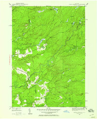 1946 North Wilmurt1958 Print · USGSThe Herkimer and Oneida county line was a landscape of remote camps and small hamlets just after World War II. Researchers can locate family landmarks like the Wheelertown Cem and the settlement of Enos along the banks of the Black River.2 unique versions available
 - 1947 Map of North Wilmurt
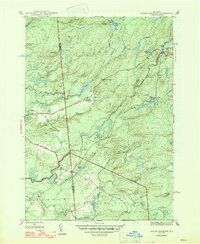 1947 North Wilmurt1947 Print · USGSThe Herkimer and Oneida county borderlands in the late 1940s reveal a network of remote camps and mountain roads within the Adirondack Park. Researchers can trace historic family landmarks such as Wheelertown Cem and old settlements like Enos and North Wilmurt.2 unique versions available
End of results
Showing maps 1-2 of 2
Top cities near North Wilmurt
- Marcy historical maps
- Boonville historical maps
- Trenton historical maps
- Deerfield historical maps
- Floyd historical maps
- Russia historical maps
See more
Frequently asked questions
- What are the different types of historical maps available for North Wilmurt?
- What is the oldest map of North Wilmurt?
- Where can I purchase historical maps of North Wilmurt for my home or office?
- Where can I download high-res historical maps of North Wilmurt?
- Are there historical topographic maps available for North Wilmurt?
- Is there historical aerial imagery available for North Wilmurt?
- Where are historical maps of North Wilmurt sourced from?