1980s Maps of Thendara, Webb
Explore 4 historic maps of Thendara from the 1980s. These maps offer a rare glimpse into what life looked like during the 1980s — showing old roads, neighborhoods, homes, and landmarks that have changed or disappeared over time.
Whether you're researching your family's past, planning a metal detecting trip, or studying how Thendara's landscape evolved across the 1980s, these high-resolution maps are a powerful tool for exploring the history of this region.
- Focus on a specific era: All maps on this page are from the 1980s, giving you a focused view of this time period.
- See what’s changed: Compare century-old streets, trails, and buildings to today's modern landscape using overlays and satellite layers.
- Research with precision: Use these maps for genealogy, historical research, land use analysis, or educational projects.
- View, download, or print: Maps are fully viewable online in high resolution, and can be downloaded or printed for your own records.
Start exploring Thendara's history through authentic maps from the 1980s. This is your window into the past.
Thendara, Webb maps
(4)- 1985 Map of Watertown, 1986 Print
 1985 Watertown1986 Print · USGSThe Black River Valley and the western Adirondacks are captured here in the mid-1980s, from the urban streets of Watertown to the remote Stillwater Reservoir. Researchers can trace the Conrail lines through Carthage or locate family landmarks in Lowville, Boonville, and Old Forge.2 unique versions available
 - 1985 Map of Raquette Lake, 1986 Print
 1985 Raquette Lake1986 Print · USGSThe central Adirondacks are documented here in the mid-1980s, showcasing the complex lake systems and early rail routes that defined the region. Researchers can trace historic landmarks like Sagamore, isolated stops along the Adirondack RR, and the remote layout of Old Forge.2 unique versions available
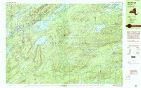
 - 1989 Map of Thendara
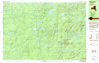 1989 Thendara1989 Print · USGSThe western Adirondacks in the late 1980s are preserved here in detail, showing a landscape defined by forest and water. Researchers can trace the layout of Thendara, locate the remote Middle Settlement Lake, or study the peaks of Moose River Mountain.2 unique versions available
 - 1989 Map of Old Forge, 1990 Print
 1989 Old Forge1990 Print · USGSThe Adirondack wilderness around Herkimer County is captured here in the late eighties, centered on the historic mountain gateway of Old Forge. Outdoor researchers can trace the intricate trails and waters from Little Moose Lake to the summits of Bald Mtn and McCauley Mtn.
End of results
Showing maps 1-4 of 4
Top cities near Thendara
- Boonville historical maps
- Croghan historical maps
- Watson historical maps
- Webb historical maps
- Forestport historical maps
- Greig historical maps
See more
Frequently asked questions
- What are the different types of historical maps available for Thendara?
- What is the oldest map of Thendara?
- Where can I purchase historical maps of Thendara for my home or office?
- Where can I download high-res historical maps of Thendara?
- Are there historical topographic maps available for Thendara?
- Is there historical aerial imagery available for Thendara?
- Where are historical maps of Thendara sourced from?