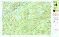
1989 Map of Old Forge
USGS Topo · Published 1990About this map
Old Forge and Inlet serve as the primary gateways to this pocket of the western Adirondack Park. The landscape is dominated by the intricate drainage of the Moose River, including the South Branch Moose River and the sprawling waters of Little Moose Lake. At this time, the area shows a transition from the village infrastructure at the Old Forge Airport and the local Golf Course to the high peaks of Little Moose Mountain and Woodhull Mtn. Numerous smaller bodies of water, such as Panther Lake, Nicks Lake, and the curiously named Stink Lake, are scattered throughout the Herkimer and Hamilton County borderlands. The map documents the established recreation and wilderness boundaries before the further modernization of the late 20th century, capturing landmarks like McCauley Mtn and Mountain Lodge in their late-1980s context.
Find a feature on this map
84 named features on this map. Tap any name to fly to it.
Don’t see what you’re looking for? This feature index may not catch every label — zoom into the map to look around manually.
Map Details
Editions of this 1989 Old Forge Map
This is the sole edition of this map. No revisions or reprints were ever made.
Other maps of this area

1900 · Canada Lake
USGS Topo · 1:62,500

1901 · Old Forge
USGS Topo · 1:62,500

1903 · Big Moose
USGS Topo · 1:62,500

1903 · West Canada Lakes
USGS Topo · 1:62,500

1903 · Raquette Lake
USGS Topo · 1:62,500

1912 · Number Four
USGS Topo · 1:62,500

1912 · Mc Keever
USGS Topo · 1:62,500

1915 · Number Four
USGS Topo · 1:62,500

1950 · Utica
USGS Topo · 1:250,000

1954 · Old Forge
USGS Topo · 1:62,500