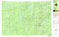
1989 Map of Thendara
USGS Topo · Published 1989About this map
Adirondack Park dominates this late-twentieth-century landscape, capturing a wilderness region defined by its dense network of glacial ponds and mountain ridges. The settlement of Thendara serves as the primary eastern gateway, situated where the terrain begins its ascent toward Moose River Mountain. This map documents the complex water systems that feed the region, from the expansive Big Otter Lake in the north to the smaller, secluded basins of Middle Settlement Lake and Nick's Lake. The survey details the high-altitude topography of the Webb and Greig town lines, illustrating the land's transition from the creek-carved lowlands near Hubbards to the prominent peaks of Flatrock Mountain and Tooker Mountain. This era of the park's history is characterized by a balance between the small-scale development in Thendara and the vast, protected reaches of the forest preserve.
Find a feature on this map
60 named features on this map. Tap any name to fly to it.
Don’t see what you’re looking for? This feature index may not catch every label — zoom into the map to look around manually.
Map Details
Editions of this 1989 Thendara Map
2 editions found
Other maps of this area

1901 · Old Forge
USGS Topo · 1:62,500

1903 · Big Moose
USGS Topo · 1:62,500

1905 · Port Leyden
USGS Topo · 1:62,500

1907 · Port Leyden
USGS Topo · 1:62,500

1911 · Lowville
USGS Topo · 1:62,500

1912 · Number Four
USGS Topo · 1:62,500

1912 · Mc Keever
USGS Topo · 1:62,500

1913 · Lowville
USGS Topo · 1:62,500

1915 · Number Four
USGS Topo · 1:62,500

1940 · Port Leyden
USGS Topo · 1:62,500