1980s Maps of Jefferson County, New York
Explore 6 historic maps of Jefferson County from the 1980s. These maps offer a rare glimpse into what life looked like during the 1980s — showing old roads, neighborhoods, homes, and landmarks that have changed or disappeared over time.
Whether you're researching your family's past, planning a metal detecting trip, or studying how Jefferson County's landscape evolved across the 1980s, these high-resolution maps are a powerful tool for exploring the history of this region.
- Focus on a specific era: All maps on this page are from the 1980s, giving you a focused view of this time period.
- See what’s changed: Compare century-old streets, trails, and buildings to today's modern landscape using overlays and satellite layers.
- Research with precision: Use these maps for genealogy, historical research, land use analysis, or educational projects.
- View, download, or print: Maps are fully viewable online in high resolution, and can be downloaded or printed for your own records.
Start exploring Jefferson County's history through authentic maps from the 1980s. This is your window into the past.
Jefferson County, NY maps
(6)- 1980 Map of Henderson Bay, 1983 Print
 1980 Henderson Bay1983 Print · USGSThe Jefferson County shoreline comes alive in the early 1980s, where the historic military grounds of Sackets Harbor meet the waters of Lake Ontario. Genealogists and historians can trace family plots at Stone Cem or Ferry Cem and explore the rugged points from Pillar Point to Stony Point.
 - 1982 Map of La Fargeville, 1983 Print
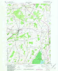 1982 La Fargeville1983 Print · USGSJefferson County agricultural life and conservation lands are captured here in the early eighties. Genealogists and local historians can trace family burial plots at Beech Ridge Cem or locate former rail routes like the Old Railroad Grade.
 - 1985 Map of Pulaski
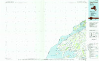
 1985 Pulaski1985 Print · USGSThe eastern shores of Lake Ontario in the mid-1980s showcase a landscape of protected wetlands and historic harbor towns. Trace the paths of the CONRAIL railroad and explore the coastal heritage of Sackets Harbor, Port Ontario, and Selkirk Shores State Park.2 unique versions available
 - 1985 Map of Gouverneur
 1985 Gouverneur1985 Print · USGSSt. Lawrence and Jefferson Counties are shown in the mid-eighties as a landscape of river-driven industry and expanding military grounds. Genealogists and historians can trace rail lines through Carthage, find local landmarks like Noble Hospital, and locate the boundaries of the Fort Drum Military Reservation.2 unique versions available
 - 1985 Map of Cape Vincent
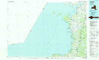
 1985 Cape Vincent1985 Print · USGSThe Thousand Islands and the Jefferson County shoreline are documented in the mid-1980s as the river meets the lake. Genealogists and local historians can trace an Old Railroad Grade and explore settlements like Cape Vincent, Clayton, and Rosiere.2 unique versions available
 - 1985 Map of Watertown, 1986 Print
 1985 Watertown1986 Print · USGSThe Black River Valley and the western Adirondacks are captured here in the mid-1980s, from the urban streets of Watertown to the remote Stillwater Reservoir. Researchers can trace the Conrail lines through Carthage or locate family landmarks in Lowville, Boonville, and Old Forge.2 unique versions available
End of results
Showing maps 1-6 of 6
Top cities of Jefferson County
- Le Ray historical maps
- Watertown historical maps
- Watertown historical maps
- Brownville historical maps
- Wilna historical maps
- Adams historical maps
See more
Frequently asked questions
- What are the different types of historical maps available for Jefferson County?
- What is the oldest map of Jefferson County?
- Where can I purchase historical maps of Jefferson County for my home or office?
- Where can I download high-res historical maps of Jefferson County?
- Are there historical topographic maps available for Jefferson County?
- Is there historical aerial imagery available for Jefferson County?
- Where are historical maps of Jefferson County sourced from?