2020s Maps of Jefferson County, New York
Explore 42 historic maps of Jefferson County from the 2020s. These maps offer a rare glimpse into what life looked like during the 2020s — showing old roads, neighborhoods, homes, and landmarks that have changed or disappeared over time.
Whether you're researching your family's past, planning a metal detecting trip, or studying how Jefferson County's landscape evolved across the 2020s, these high-resolution maps are a powerful tool for exploring the history of this region.
- Focus on a specific era: All maps on this page are from the 2020s, giving you a focused view of this time period.
- See what’s changed: Compare century-old streets, trails, and buildings to today's modern landscape using overlays and satellite layers.
- Research with precision: Use these maps for genealogy, historical research, land use analysis, or educational projects.
- View, download, or print: Maps are fully viewable online in high resolution, and can be downloaded or printed for your own records.
Start exploring Jefferson County's history through authentic maps from the 2020s. This is your window into the past.
Jefferson County, NY maps
(42)- 2023 Map of Galloo Island, 2023 Print
 2023 Galloo Island2023 Print · USGSJefferson County’s offshore geography is detailed in this recent survey of the eastern Great Lakes. Maritime researchers can trace the shorelines of the Galloo Islands and Little Galloo Island, as well as the protected waters of Gill Harbor.
 - 2023 Map of Barnes Corners, 2023 Print
 2023 Barnes Corners2023 Print · USGSModern Lewis County and Jefferson County geography reveals a landscape deeply incised by water and carved out by unique ravines. Genealogists and hikers can trace rural history at Saints Peter and Paul Cem or explore the steep descents of Inman Gulf and Rainbow Falls.
 - 2023 Map of Worth Center, 2023 Print
 2023 Worth Center2023 Print · USGSThe headwaters of the Tug Hill region come into focus in the 2020s, showing a landscape of dense water networks and forest management. Researchers can trace the sprawling Little John Mgt Area Sthy and the remote roads near Worth Center.
 - 2023 Map of Rodman, 2023 Print
 2023 Rodman2023 Print · USGSJefferson County's rural townships are shown here as they appeared in the early 2020s, defined by the deep ravines of Lorraine Gulf and Inman Gulf. Researchers can locate numerous local burial sites like Isham Cem and Thompson Cem near the villages of Rodman and Lorraine.
 - 2023 Map of Antwerp, 2023 Print
 2023 Antwerp2023 Print · USGSThe village of Antwerp and the northern reaches of Fort Drum are mapped here in the early twenty-first century. Genealogists and local historians can trace family plots at Hillside Cem and follow old corridors like Russell Tpke and Nauvoo School Rd.
 - 2023 Map of Philadelphia, 2023 Print
 2023 Philadelphia2023 Print · USGSThe village of Philadelphia and the crossroads at Bentleys Corners are shown in this 2023 survey of rural Jefferson County. Genealogists and local historians can locate the Quaker Cem, trace the Indian River to Childs Falls, and see the edge of Fort Drum.
 - 2023 Map of Natural Dam, 2023 Print
 2023 Natural Dam2023 Print · USGSThe St. Lawrence and Jefferson County borderlands come into focus in this contemporary survey of rural upstate New York. Genealogists and local historians can trace the roads connecting Wegatchie and Spragueville, or locate family sites near the Spragueville Cem.
 - 2023 Map of Saint Lawrence, 2023 Print
 2023 Saint Lawrence2023 Print · USGSThe international border along the Saint Lawrence River meets the rural farming country of Jefferson County in this recent survey. Genealogists and local historians can trace family-named roads and landmarks like Warren, Saint Lawrence Cemetery, and Burnt Rock.
 - 2023 Map of Thousand Island Park, 2023 Print
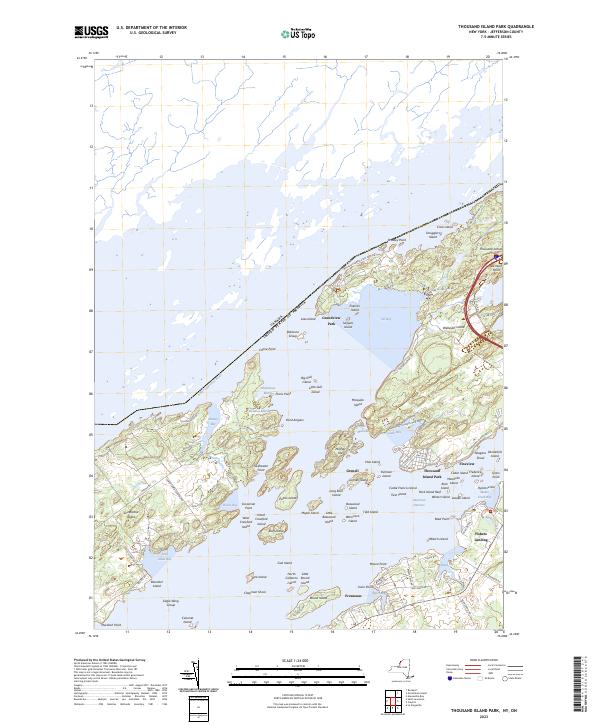 2023 Thousand Island Park2023 Print · USGSThe Thousand Islands archipelago at the modern international border reveals a landscape defined by island resorts and state parks. Genealogists can trace property lines and landing sites near Thousand Island Park, Fineview, and Grindstone Island.
 - 2023 Map of Dexter, 2023 Print
 2023 Dexter2023 Print · USGSJefferson County's shoreline and river valleys come into focus in this contemporary survey of the Lake Ontario coast. Genealogists can trace family landmarks like Luther Hill Cem and Freeman Cem or explore the area around Limerick.
 - 2023 Map of Clayton, 2023 Print
 2023 Clayton2023 Print · USGSJefferson County's northern riverfront and rural interior are captured here in the early twenty-first century. Genealogists and local historians can locate several family burial grounds, including Weaver Cem and Dutch Cem, alongside the village of Depauville.
 - 2023 Map of Cape Vincent South OE W, 2023 Print
 2023 Cape Vincent South OE W2023 Print · USGSThe international maritime boundary at the head of the Saint Lawrence River is the focus of this recent survey. Researchers can trace the border between Canada and the United States of America near the Allan Otty Shoal.
 - 2023 Map of Grindstone Island, 2023 Print
 2023 Grindstone Island2023 Print · USGSJefferson County's island life is captured here in the early twenty-first century, centered on the Grindstone Island community. Researchers can locate Thurso Cem or trace the roads like Middle Rd and Cross Island Rd.
 - 2023 Map of Cape Vincent South, 2023 Print
 2023 Cape Vincent South2023 Print · USGSCape Vincent and the eastern shores of Lake Ontario are captured here in the modern era, showing a landscape defined by its deep bays and prominent islands. Researchers can trace landforms like Point Peninsula and Grenadier Island, or locate the Saint Vincent de Paul Cem.
 - 2023 Map of Cape Vincent North, 2023 Print
 2023 Cape Vincent North2023 Print · USGSThe riverfront at Cape Vincent and the surrounding waters of the Thousand Islands region are captured in the early twenty-first century. Genealogists and researchers can locate Riverside Cem, trace the path of Horne's Ferry, and explore the shoreline of Carleton Island.
 - 2023 Map of Alexandria Bay, 2023 Print
 2023 Alexandria Bay2023 Print · USGSThe Thousand Islands region along the New York border comes into focus in this contemporary survey of the Saint Lawrence River and its waterfront resorts. Trace family connections at Saint Cyril's Cem and Houghton Cem, or explore the landing sites at Fishers Landing and Collins Landing.
 - 2023 Map of Redwood, 2023 Print
 2023 Redwood2023 Print · USGSJefferson County’s lake country is captured in the early 2020s, showing the enduring rural layout of the St. Lawrence River hinterland. Genealogists can locate family landmarks such as Barnes Cem and Hill Cem or trace the shores of Butterfield Lake.
 - 2023 Map of Muskellunge Lake, 2023 Print
 2023 Muskellunge Lake2023 Print · USGSThe Indian River valley at the Jefferson and St. Lawrence county line remains a landscape of deep glacial lakes and quiet river bends. Genealogists and local historians can trace the environs of Oxbow and Riverside, locating Saint Patricks Cem and old routes like Lead Mine Rd.
 - 2023 Map of Brownville, 2023 Print
 2023 Brownville2023 Print · USGSJefferson County's rural heartland and the sprawling wetlands of Perch Lake are documented in this recent survey. Local historians can trace family roots through several burial grounds like Rouses Cem and Stevens Cem or locate the hamlets of Stone Mills and Noseville.
 - 2023 Map of Lake Bonaparte, 2023 Print
 2023 Lake Bonaparte2023 Print · USGSThe tri-county border area of Lewis, St. Lawrence, and Jefferson Counties is shown here in its modern geography. Researchers can trace the developed shorelines of Lake Bonaparte and Sylvia Lake, or locate smaller landings and points like Bentons Point and Hitchcock Bay.
 - 2023 Map of Rockport, 2023 Print
 2023 Rockport2023 Print · USGSThe international border along the Jefferson County shoreline appears here in modern detail, focusing on the riverine boundary. Genealogists and collectors can trace the exact positions of named landforms like Whiskey Island, Arcadia Island, and Sylvan Island along the Saint Lawrence River.
 - 2023 Map of La Fargeville, 2023 Print
 2023 La Fargeville2023 Print · USGSThe rural crossroads of Jefferson County are captured in this modern survey of the La Fargeville area. Researchers can trace local lineage through numerous burial grounds like Beech Ridge Cem and Grove Cem, or locate landmarks along the Chaumont River.
 - 2023 Map of North Wilna, 2023 Print
 2023 North Wilna2023 Print · USGSThe Jefferson and Lewis County border comes to life in this recent survey of the North Wilna area. Researchers can trace the military boundary of Fort Drum alongside rural landmarks like Sand Hill Cem, Woods Mill, and Natural Bridge.
 - 2023 Map of Black River, 2023 Print
 2023 Black River2023 Print · USGSJefferson County's military and industrial history converge in this contemporary study of the area surrounding Fort Drum. Genealogists and historians can trace family locations near Evans Mills, Dutch Settlement, and several rural burial grounds like Hoover Cem.
 - 2023 Map of Deferiet, 2023 Print
 2023 Deferiet2023 Print · USGSThe military and river history of northern New York converge here as the present century progresses. Researchers can trace the boundaries of Fort Drum and find civilian landmarks like Sunnyside Cem, Wheeler-Sack Army Airfield, and the village of Deferiet.
Showing maps 1-25 of 42
Top cities of Jefferson County
- Le Ray historical maps
- Watertown historical maps
- Watertown historical maps
- Brownville historical maps
- Wilna historical maps
- Adams historical maps
See more
Frequently asked questions
- What are the different types of historical maps available for Jefferson County?
- What is the oldest map of Jefferson County?
- Where can I purchase historical maps of Jefferson County for my home or office?
- Where can I download high-res historical maps of Jefferson County?
- Are there historical topographic maps available for Jefferson County?
- Is there historical aerial imagery available for Jefferson County?
- Where are historical maps of Jefferson County sourced from?