Old Maps of Jefferson County, New York for Academic Research
Study the evolution of Jefferson County with 335 high-resolution historic maps. Whether you're teaching, researching, or modeling changes in land use, these maps provide essential visual documentation of urban, environmental, and geographic change.
- Analyze long-term change: Track patterns in development, transportation, and natural features.
- Ideal for environmental or urban studies: Support academic projects with primary historical map data.
- Use in the classroom or lab: Educators and researchers rely on these maps to bring historical context to life.
These maps are a powerful tool for teaching, research, and visualizing how Jefferson County has changed over the decades.
Jefferson County, NY maps
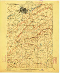
(335)- 1893 Map of Sackets Harbor, 1963 Print
 1893 Sackets Harbor1963 Print · USGSJefferson County’s shoreline at the close of the 19th century reveals a landscape of vital military outposts and thriving rail-side villages. Genealogists can trace family roots through Greens Settlement and Thomas Settlement or locate ancestors at Madison Barracks and Adams Center.
 - 1895 Map of Sacketts Harbor
 1895 Sacketts Harbor1895 Print · USGSJefferson County’s lakefront and military outposts are frozen in time during the late nineteenth century. Genealogists and historians can trace family land near Greens Settlement, locate the old Madison Barracks, or follow the Ogdensburg and Watertown R. R. through the hills.8 unique versions available
 - 1895 Map of Stony Island
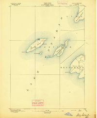 1895 Stony Island1895 Print · USGSLake Ontario's eastern islands and Jefferson County shoreline are documented in the 1890s as critical navigation points. Maritimers and local historians can trace the positions of the Galloup Id. L.H. and Stony Point L.H. among islands like Stony Island.6 unique versions available
 - 1895 Map of Pulaski
 1895 Pulaski1895 Print · USGSCoastal Oswego and Jefferson Counties are captured here in the late 1800s, where the Salmon River meets the lake. Genealogists can trace family roots through settlements like Richland, Pulaski, and the lakeside Life Saving Station.8 unique versions available
 - 1895 Map of Watertown
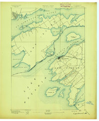
 1895 Watertown1895 Print · USGSJefferson County in the 1890s centered on the industrial energy of the Black River and a complex web of iron rails. Genealogists and local researchers can trace historic crossroads such as Fields Settlement, Whitford Corner, and Burrs Mills.
 - 1895 Map of Cape Vincent
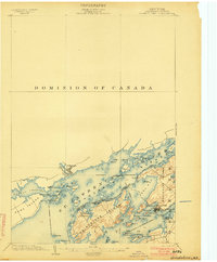
 1895 Cape Vincent1895 Print · USGSUpper New York and the Canadian border meet at the head of the St. Lawrence River during the peak of the steamboat era. Genealogists and historians can trace the Cape Vincent Branch railroad and locate early shoreline landmarks like Tibbetts Pt. L.H. and the village of Marysville.6 unique versions available
 - 1898 Map of Watertown
 1898 Watertown1898 Print · USGSJefferson County at the close of the nineteenth century centers on the growing hub of Watertown and its intricate rail network. Researchers can trace the nineteenth-century landscape of rural hamlets, mills, and family landmarks like Burrs Mills, Honeyville, and Fields Settlement.2 unique versions available
 - 1900 Map of Clayton, 1957 Print
 1900 Clayton1957 Print · USGSThe Thousand Islands region and the St. Lawrence riverfront are captured here at the turn of the century, showing a landscape defined by steam and rail. Genealogists can trace family roots in CLAYTON, Chaumont, and Depauville, or follow the path of the Electric R.R. near Dexter.
 - 1902 Map of Carthage
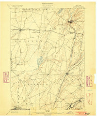
 1902 Carthage1902 Print · USGSUpper New York at the turn of the century shows a landscape of river-powered industry and sprawling hill farms. Genealogists can trace family names and old crossroads from Champion Huddle to Gardners Corners, while rail historians can follow the R. W. and O. Div. through the Black River valley.
 - 1903 Map of Grindstone
 1903 Grindstone1903 Print · USGSThe Thousand Islands at the turn of the century are captured here along the international border as steamboat traffic flourished. Genealogists and historians can trace old resort landings like Thousand Island Park and Fineview or locate several distinct river beacons including Rock I. L.H. and Lindoe L.H..4 unique versions available
 - 1903 Map of Clayton
 1903 Clayton1903 Print · USGSJefferson County's Thousand Islands region and Lake Ontario shoreline are documented here just after the turn of the century. Genealogists and historians can trace the rail lines connecting Clayton and Chaumont, or locate old post offices in Depauville and Rosiere.6 unique versions available
 - 1903 Map of Alexandria Bay
 1903 Alexandria Bay1903 Print · USGSThe Thousand Islands region appears here at the turn of the century as a burgeoning summer retreat along the international border. Genealogists and local historians can trace the early layouts of Alexandria Bay, the rail corridor through Redwood, and numerous island landings like Collins Landing.6 unique versions available
 - 1903 Map of Theresa
 1903 Theresa1903 Print · USGSJefferson County at the turn of the century was a bustling network of dairy farms and rail junctions. You can trace the path of the Rome Watertown and Ogdensburg Div. through Evans Mills or locate early settlements like Stone Mills and Leraysville.8 unique versions available
 - 1903 Map of Orwell, 1955 Print
 1903 Orwell1955 Print · USGSOswego and Jefferson counties are documented here at the opening of the twentieth century, showing a landscape defined by the Tug Hill drainages. Genealogists and historians can trace the early footprints of Littlejohn Settlement, Otto Mills, and the falls at Stillwater.
 - 1904 Map of Carthage
 1904 Carthage1904 Print · USGSJefferson and Lewis Counties at the turn of the century show a landscape defined by the Black River valley and its busy rail lines. Genealogists can trace early homesteads in rural outposts like Champion Huddle, Windecker, and Gardners Corners.6 unique versions available
 - 1905 Map of Orwell
 1905 Orwell1905 Print · USGSUpper Oswego and Jefferson counties are shown here in the early nineteen-hundreds as a landscape of remote settlements and river-powered valleys. Genealogists and historians can trace the exact locations of Little John Settlement, the Salmon Falls cataracts, and Bennett Bridge.6 unique versions available
 - 1908 Map of Watertown, 1955 Print
 1908 Watertown1955 Print · USGSWatertown and the rural uplands of the Tug Hill region are captured here in the early twentieth century as the railroad era peaked. Genealogists can trace early post offices like Klondike and Whitesville, or locate family sites near Brookside Cemetery.
 - 1909 Map of Watertown
 1909 Watertown1909 Print · USGSJefferson County was at its industrial and agrarian height in the early twentieth century, centered on the vital rail hub of Watertown. Local historians can trace family roots through the Middle Road Church or locate vanished post offices like Klondike Worth and Tylerville South Rutland.6 unique versions available
 - 1911 Map of Antwerp
 1911 Antwerp1911 Print · USGSJefferson County was a landscape of bustling river towns and intersecting rail lines just after the turn of the century. Trace the early footprints of Antwerp and Sterlingville, or locate family landmarks like Bishops Corners and Woods Mill.6 unique versions available
 - 1912 Map of Hammond
 1912 Hammond1912 Print · USGSThe rural borderlands of St. Lawrence and Jefferson counties are captured here in the early twentieth century. Genealogists and historians can trace defunct district schools like California School and Stark School, or locate the Old Iron Works and rail stops at South Hammond Oakvale Sta.4 unique versions available
 - 1913 Map of Lake Bonaparte, 1956 Print
 1913 Lake Bonaparte1956 Print · USGSThe Lewis and Jefferson County borderlands come to life in this pre-World War I survey of the Lake Bonaparte region. Researchers can trace the old New York Central rail line past historic landmarks like Kimball Mill and the French Settlement School.
 - 1916 Map of Lake Bonaparte
 1916 Lake Bonaparte1916 Print · USGSUpper New York State at the dawn of the twentieth century shows a landscape defined by isolated settlements and a budding rail network. Researchers can trace the legacy of early families and industry through sites like Kimball Mill, Natural Bridge, and the French Settlement School.5 unique versions available
 - 1942 Map of Stony Point
 1942 Stony Point1942 Print · USGSThe Jefferson County shoreline of Lake Ontario is captured here during the early years of World War II. Researchers can locate the Stony Point Light House and the extensive Stony Point Rifle Range along the coast of Henderson.
 - 1942 Map of Cape Vincent North
 1942 Cape Vincent North1942 Print · USGSThe international border along the Thousand Islands comes into sharp focus during the early 1940s. Genealogists and local historians can trace rural landmarks like Riverside Cem, School No 13, and the grounds of Burnham Pt State Park.
 - 1942 Map of Henderson Bay
 1942 Henderson Bay1942 Print · USGSJefferson County’s shoreline comes alive in the early 1940s, highlighting the military presence at the historic Madison Barracks. Researchers can trace old lakeside schoolhouses and family cemeteries like Stone Cem or explore the waterfront detail near Sackets Harbor.
Showing maps 1-25 of 335
Top cities of Jefferson County
- Le Ray historical maps
- Watertown historical maps
- Watertown historical maps
- Brownville historical maps
- Wilna historical maps
- Adams historical maps
See more
Frequently asked questions
- What are the different types of historical maps available for Jefferson County?
- What is the oldest map of Jefferson County?
- Where can I purchase historical maps of Jefferson County for my home or office?
- Where can I download high-res historical maps of Jefferson County?
- Are there historical topographic maps available for Jefferson County?
- Is there historical aerial imagery available for Jefferson County?
- Where are historical maps of Jefferson County sourced from?