1890s Maps of Jefferson County, New York
Explore 7 historic maps of Jefferson County from the 1890s. These maps offer a rare glimpse into what life looked like during the 1890s — showing old roads, neighborhoods, homes, and landmarks that have changed or disappeared over time.
Whether you're researching your family's past, planning a metal detecting trip, or studying how Jefferson County's landscape evolved across the 1890s, these high-resolution maps are a powerful tool for exploring the history of this region.
- Focus on a specific era: All maps on this page are from the 1890s, giving you a focused view of this time period.
- See what’s changed: Compare century-old streets, trails, and buildings to today's modern landscape using overlays and satellite layers.
- Research with precision: Use these maps for genealogy, historical research, land use analysis, or educational projects.
- View, download, or print: Maps are fully viewable online in high resolution, and can be downloaded or printed for your own records.
Start exploring Jefferson County's history through authentic maps from the 1890s. This is your window into the past.
Jefferson County, NY maps
(7)- 1893 Map of Sackets Harbor, 1963 Print
 1893 Sackets Harbor1963 Print · USGSJefferson County’s shoreline at the close of the 19th century reveals a landscape of vital military outposts and thriving rail-side villages. Genealogists can trace family roots through Greens Settlement and Thomas Settlement or locate ancestors at Madison Barracks and Adams Center.
 - 1895 Map of Sacketts Harbor
 1895 Sacketts Harbor1895 Print · USGSJefferson County’s lakefront and military outposts are frozen in time during the late nineteenth century. Genealogists and historians can trace family land near Greens Settlement, locate the old Madison Barracks, or follow the Ogdensburg and Watertown R. R. through the hills.8 unique versions available
 - 1895 Map of Stony Island
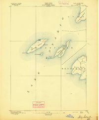 1895 Stony Island1895 Print · USGSLake Ontario's eastern islands and Jefferson County shoreline are documented in the 1890s as critical navigation points. Maritimers and local historians can trace the positions of the Galloup Id. L.H. and Stony Point L.H. among islands like Stony Island.6 unique versions available
 - 1895 Map of Pulaski
 1895 Pulaski1895 Print · USGSCoastal Oswego and Jefferson Counties are captured here in the late 1800s, where the Salmon River meets the lake. Genealogists can trace family roots through settlements like Richland, Pulaski, and the lakeside Life Saving Station.8 unique versions available
 - 1895 Map of Watertown
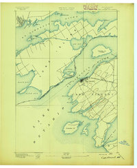
 1895 Watertown1895 Print · USGSJefferson County in the 1890s centered on the industrial energy of the Black River and a complex web of iron rails. Genealogists and local researchers can trace historic crossroads such as Fields Settlement, Whitford Corner, and Burrs Mills.
 - 1895 Map of Cape Vincent
 1895 Cape Vincent1895 Print · USGSUpper New York and the Canadian border meet at the head of the St. Lawrence River during the peak of the steamboat era. Genealogists and historians can trace the Cape Vincent Branch railroad and locate early shoreline landmarks like Tibbetts Pt. L.H. and the village of Marysville.6 unique versions available
 - 1898 Map of Watertown
 1898 Watertown1898 Print · USGSJefferson County at the close of the nineteenth century centers on the growing hub of Watertown and its intricate rail network. Researchers can trace the nineteenth-century landscape of rural hamlets, mills, and family landmarks like Burrs Mills, Honeyville, and Fields Settlement.2 unique versions available
End of results
Showing maps 1-7 of 7
Top cities of Jefferson County
- Le Ray historical maps
- Watertown historical maps
- Watertown historical maps
- Brownville historical maps
- Wilna historical maps
- Adams historical maps
See more
Frequently asked questions
- What are the different types of historical maps available for Jefferson County?
- What is the oldest map of Jefferson County?
- Where can I purchase historical maps of Jefferson County for my home or office?
- Where can I download high-res historical maps of Jefferson County?
- Are there historical topographic maps available for Jefferson County?
- Is there historical aerial imagery available for Jefferson County?
- Where are historical maps of Jefferson County sourced from?