Old Maps of Groveland, New York for Academic Research
Study the evolution of Groveland with 42 high-resolution historic maps. Whether you're teaching, researching, or modeling changes in land use, these maps provide essential visual documentation of urban, environmental, and geographic change.
- Analyze long-term change: Track patterns in development, transportation, and natural features.
- Ideal for environmental or urban studies: Support academic projects with primary historical map data.
- Use in the classroom or lab: Educators and researchers rely on these maps to bring historical context to life.
These maps are a powerful tool for teaching, research, and visualizing how Groveland has changed over the decades.
Groveland, NY maps
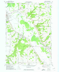
(42)- 1901 Map of Honeoye, 1954 Print
 1901 Honeoye1954 Print · USGSThe Finger Lakes region at the turn of the century was a bustling corridor of milling and rail transit. Genealogists and rail historians can trace the intricate routes of the Lehigh Valley and Erie RR between settlements like Honeoye Falls and Richmond Mills.
 - 1902 Map of Wayland, 1954 Print
 1902 Wayland1954 Print · USGSThe Finger Lakes region at the turn of the century shows a landscape of steep ridges and critical rail junctions. Genealogists and historians can trace the paths of the Erie RR through Dansville or locate smaller settlements like Perkinsville and Springwater.
 - 1904 Map of Wayland
 1904 Wayland1904 Print · USGSThe western Finger Lakes region in the early 1900s was a bustling corridor of industry and rail. Genealogists and historians can trace the early grid of Dansville, the milling operations at Stones Falls Mill, and the shores of Hemlock Lake.7 unique versions available
 - 1904 Map of Caledonia
 1904 Caledonia1904 Print · USGSLivingston County and its surrounding borders are shown here at the height of the early railroad era. Researchers can trace the complex rail junctions at Caledonia or locate vanished landmarks and post offices like Wadsworth P.O. S.Greigsville and Retsof.6 unique versions available
 - 1904 Map of Honeoye
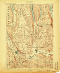
 1904 Honeoye1904 Print · USGSThe Finger Lakes region thrived at the start of the century as a vital rail and milling corridor. Researchers can trace the path of the Electric R. R. and locate family landmarks like Jakman Hill or the old milling sites at Richmond Mills.6 unique versions available
 - 1905 Map of Nunda
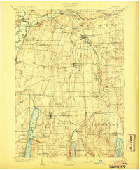
 1905 Nunda1905 Print · USGSLivingston County rail and river life are captured here at the turn of the century, centered on the Genesee River valley. Trace the vanished streets of St Helena, locate the Sonyea P O Craig Colony, and follow the complex rail junctions at Mount Morris.6 unique versions available
 - 1942 Map of Conesus
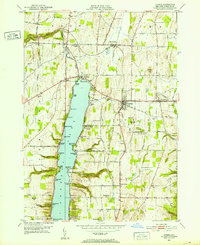
 1942 Conesus1942 Print · USGSLivingston County's eastern uplands and lakeside shores are captured here during the early war years. Researchers can trace the footprints of numerous district schools and small hamlets like Scottsburg or find family history at Lakeview Cem and St Michaels Mission.
 - 1942 Map of Livonia
 1942 Livonia1942 Print · USGSConesus Lake's eastern shore and the surrounding uplands are captured here during the early war years. Genealogists and local historians can trace family locations through named sites like Alger Cem, School No 7, and the lakeside Excelsior Springs.
 - 1943 Map of Sonyea, 1960 Print
 1943 Sonyea1960 Print · USGSLivingston County in the early 1940s is a landscape of valley rail lines and institutional grounds. Genealogists and historians can trace the expansive Craig Colony campus, the small rail stop at Sonyea, and rural settlements like Kysorville and Tuscarora.
 - 1944 Map of Sonyea
 1944 Sonyea1944 Print · USGSThe Genesee Valley during the mid-forties reveals a landscape of vital rail corridors and institutional centers. Local historians can trace the grounds of Craig Colony and the rail junctions at Groveland Sta and Tuscarora.
 - 1944 Map of Geneseo
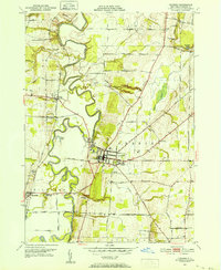
 1944 Geneseo1944 Print · USGSLivingston County's river valley and rail corridors are captured in detail during the mid-1940s. Genealogists and local historians can locate rural landmarks like State Normal School, the Temple Hill Cem, and numerous district schools.
 - 1950 Map of Elmira
 1950 Elmira1950 Print · USGSThe Finger Lakes region thrived in the late 1940s as a hub of industry and transport. Trace family roots and vanished landmarks near Seneca Lake or explore the rail lines of the Erie RR and the sprawling Seneca Ordnance Depot.2 unique versions available
 - 1950 Map of Geneseo, 1952 Print
 1950 Geneseo1952 Print · USGSMid-century Livingston County centers on the winding Genesee River and the expanding village of Geneseo. Genealogists and local historians can trace legacy sites like Temple Hill Cemetery, the State Teachers College, and the rail lines serving the Salt Mines (Inactive).4 unique versions available
 - 1951 Map of Livonia, 1952 Print
 1951 Livonia1952 Print · USGSLakeside life and rail travel meet in the early fifties as the shores of Conesus Lake begin to fill with cottages and landings. Researchers can trace family sites near Livonia Center or locate rural landmarks like Mt Pleasant Cem and the Erie RR line.4 unique versions available
 - 1951 Map of Caledonia, 1956 Print
 1951 Caledonia1956 Print · USGSThe Genesee Valley flourished as a rail crossroads in the early fifties, where five major lines converged near the river. Local historians can trace family-named corners and rural institutions like St Columbus Ch, Machpelah Cem, and Retsof Central Sch.2 unique versions available
 - 1957 Map of Conesus
 1957 Conesus1957 Print · USGSMid-century Livingston County comes to life here as the Finger Lakes region balances lakeside recreation with deep-rooted agricultural life. Trace historic family sites and district schoolhouses from St Michaels Mission down to Websters Crossing and the Lakeview Cem shoreline.
 - 1958 Map of Elmira
 1958 Elmira1958 Print · USGSThe New York Finger Lakes during the late fifties reveal a complex landscape of glacial geology and industrial growth. Researchers can trace historic transport corridors like the Erie Canal and Erie RR, or locate institutional landmarks like Cornell University.2 unique versions available
 - 1962 Map of Elmira, 1969 Print
 1962 Elmira1969 Print · USGSThe Finger Lakes region and Southern Tier are captured here during a period of industrial maturity and highway expansion. Researchers can trace the path of the Erie Canal, the footprint of the Seneca Army Depot, and legacy rail lines through Elmira and Ithaca.4 unique versions available
 - 1964 Map of Conesus
 1964 Conesus1964 Print · USGSThe Finger Lakes region of western New York appears here in the mid-twentieth century, dominated by the southern basin of Conesus Lake. Researchers can trace old family cemetery plots like Clark Cem and vanished rural schoolhouses such as School No 2 or School No 7.
 - 1965 Map of Elmira
 1965 Elmira1965 Print · USGSThe Finger Lakes and Southern Tier regions are captured in the mid-sixties, showcasing a landscape of deep glacial valleys and heavy rail infrastructure. Trace old railroad corridors like the Pennsylvania RR or visit landmarks like Letchworth State Park and the Seneca Army Depot.
 - 1972 Map of Sonyea, 1974 Print
 1972 Sonyea1974 Print · USGSLivingston County in the early seventies shows a landscape of institutional history and river valley rail lines. Genealogists can locate family names at Williamsburgh Cem or trace the grounds of the Craig State School near Sonyea.2 unique versions available
 - 1983 Map of Canandaigua, 1985 Print
 1983 Canandaigua1985 Print · USGSThe Finger Lakes and Genesee Valley appear in high detail in the early 1980s as the region's transport and academic centers reached a peak. Researchers can trace rail lines like the Lehigh Valley RR and find landmarks such as the Mount Morris Dam and Gannagaro State Historical Site.2 unique versions available
 - 2010 Map of Conesus, 2010 Print
 2010 Conesus2010 Print · USGSCovers Groveland, including Conesus, Springwater, and other nearby areas
 - 2010 Map of Geneseo, 2010 Print
 2010 Geneseo2010 Print · USGSCovers Groveland, including Geneseo, Geneseo, and other nearby areas
 - 2010 Map of Sonyea, 2010 Print
 2010 Sonyea2010 Print · USGSCovers Groveland, including Mount Morris, Mount Morris, and other nearby areas
Showing maps 1-25 of 42
Top cities near Groveland
- Geneseo historical maps
- Geneseo historical maps
- Livonia historical maps
- Avon historical maps
- Perry historical maps
- North Dansville historical maps
See more
Top neighborhoods of Groveland
- Maple Beach historical maps
- East Groveland historical maps
- Groveland Corners historical maps
- Sonyea historical maps
- Cottonwood Point historical maps
Frequently asked questions
- What are the different types of historical maps available for Groveland?
- What is the oldest map of Groveland?
- Where can I purchase historical maps of Groveland for my home or office?
- Where can I download high-res historical maps of Groveland?
- Are there historical topographic maps available for Groveland?
- Is there historical aerial imagery available for Groveland?
- Where are historical maps of Groveland sourced from?