1940s Maps of Leicester, New York
Explore 6 historic maps of Leicester from the 1940s. These maps offer a rare glimpse into what life looked like during the 1940s — showing old roads, neighborhoods, homes, and landmarks that have changed or disappeared over time.
Whether you're researching your family's past, planning a metal detecting trip, or studying how Leicester's landscape evolved across the 1940s, these high-resolution maps are a powerful tool for exploring the history of this region.
- Focus on a specific era: All maps on this page are from the 1940s, giving you a focused view of this time period.
- See what’s changed: Compare century-old streets, trails, and buildings to today's modern landscape using overlays and satellite layers.
- Research with precision: Use these maps for genealogy, historical research, land use analysis, or educational projects.
- View, download, or print: Maps are fully viewable online in high resolution, and can be downloaded or printed for your own records.
Start exploring Leicester's history through authentic maps from the 1940s. This is your window into the past.
Leicester, NY maps
(6)- 1943 Map of Mount Morris
 1943 Mount Morris1943 Print · USGSDuring the war years, this corner of the Genesee Valley was a landscape of dramatic river gorges and quiet upland farming. Genealogists and historians can trace the early road networks connecting Mount Morris and Perry or locate rural hamlets like Brooks Grove and Simmons Corners.2 unique versions available
 - 1943 Map of Sonyea, 1960 Print
 1943 Sonyea1960 Print · USGSLivingston County in the early 1940s is a landscape of valley rail lines and institutional grounds. Genealogists and historians can trace the expansive Craig Colony campus, the small rail stop at Sonyea, and rural settlements like Kysorville and Tuscarora.
 - 1944 Map of Sonyea
 1944 Sonyea1944 Print · USGSThe Genesee Valley during the mid-forties reveals a landscape of vital rail corridors and institutional centers. Local historians can trace the grounds of Craig Colony and the rail junctions at Groveland Sta and Tuscarora.
 - 1944 Map of Geneseo
 1944 Geneseo1944 Print · USGSLivingston County's river valley and rail corridors are captured in detail during the mid-1940s. Genealogists and local historians can locate rural landmarks like State Normal School, the Temple Hill Cem, and numerous district schools.
 - 1944 Map of Mount Morris
 1944 Mount Morris1944 Print · USGSThe Genesee Valley during the mid-forties was a landscape of dramatic river bluffs and vital rail junctions. Genealogists and local historians can trace family-named routes like Hendershot Road and locate rural hubs such as Brooks Grove and Ridge.
 - 1944 Map of Leicester
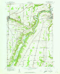
 1944 Leicester1944 Print · USGSLivingston County’s Genesee Valley was a powerhouse of rail transport and rural industry in the mid-forties. Genealogists and industrial historians can trace early property lines near Olivet Cem, find School No 7, and follow the junction of the Genesee and Wyoming Railroad through Retsof and Leicester.
End of results
Showing maps 1-6 of 6
Top cities near Leicester
- Geneseo historical maps
- LeRoy historical maps
- Geneseo historical maps
- Livonia historical maps
- Avon historical maps
- Perry historical maps
See more
Top neighborhoods of Leicester
- Teed Corners historical maps
- Pine Tavern historical maps
- Leicester historical maps
- Cuylerville historical maps
Frequently asked questions
- What are the different types of historical maps available for Leicester?
- What is the oldest map of Leicester?
- Where can I purchase historical maps of Leicester for my home or office?
- Where can I download high-res historical maps of Leicester?
- Are there historical topographic maps available for Leicester?
- Is there historical aerial imagery available for Leicester?
- Where are historical maps of Leicester sourced from?