1940s Maps of Lima, New York
Explore 3 historic maps of Lima from the 1940s. These maps offer a rare glimpse into what life looked like during the 1940s — showing old roads, neighborhoods, homes, and landmarks that have changed or disappeared over time.
Whether you're researching your family's past, planning a metal detecting trip, or studying how Lima's landscape evolved across the 1940s, these high-resolution maps are a powerful tool for exploring the history of this region.
- Focus on a specific era: All maps on this page are from the 1940s, giving you a focused view of this time period.
- See what’s changed: Compare century-old streets, trails, and buildings to today's modern landscape using overlays and satellite layers.
- Research with precision: Use these maps for genealogy, historical research, land use analysis, or educational projects.
- View, download, or print: Maps are fully viewable online in high resolution, and can be downloaded or printed for your own records.
Start exploring Lima's history through authentic maps from the 1940s. This is your window into the past.
Lima, NY maps
(3)- 1942 Map of Honeoye
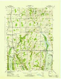 1942 Honeoye1942 Print · USGSThe Finger Lakes region comes to life in the early 1940s as lakeside settlements and hill-country farms define the local landscape. Genealogists and researchers can trace family landmarks like Short Cem, old school districts, and the path of the Lehigh Valley railroad through Hemlock.
 - 1942 Map of Honeoye Falls
 1942 Honeoye Falls1942 Print · USGSWestern New York at the onset of the 1940s reveals a landscape of thriving rail hubs and rural crossroads villages. Genealogists can trace family names through landmarks like Quaker Cem or Graves Cem and locate historic rural schools such as School No 10.
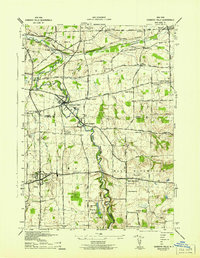
 - 1942 Map of Livonia
 1942 Livonia1942 Print · USGSConesus Lake's eastern shore and the surrounding uplands are captured here during the early war years. Genealogists and local historians can trace family locations through named sites like Alger Cem, School No 7, and the lakeside Excelsior Springs.
End of results
Showing maps 1-3 of 3
Top cities near Lima
- Rochester historical maps
- Perinton historical maps
- Henrietta historical maps
- Penfield historical maps
- Brighton historical maps
- Pittsford historical maps
See more
Top neighborhoods of Lima
Frequently asked questions
- What are the different types of historical maps available for Lima?
- What is the oldest map of Lima?
- Where can I purchase historical maps of Lima for my home or office?
- Where can I download high-res historical maps of Lima?
- Are there historical topographic maps available for Lima?
- Is there historical aerial imagery available for Lima?
- Where are historical maps of Lima sourced from?