1900-1909 Maps of Monroe County, New York
Explore 6 historic maps of Monroe County from 1900-1909. These maps offer a rare glimpse into what life looked like during the 1900s — showing old roads, neighborhoods, homes, and landmarks that have changed or disappeared over time.
Whether you're researching your family's past, planning a metal detecting trip, or studying how Monroe County's landscape evolved across the 1900s, these high-resolution maps are a powerful tool for exploring the history of this region.
- Focus on a specific era: All maps on this page are from the 1900s, giving you a focused view of this time period.
- See what’s changed: Compare century-old streets, trails, and buildings to today's modern landscape using overlays and satellite layers.
- Research with precision: Use these maps for genealogy, historical research, land use analysis, or educational projects.
- View, download, or print: Maps are fully viewable online in high resolution, and can be downloaded or printed for your own records.
Start exploring Monroe County's history through authentic maps from the 1900s. This is your window into the past.
Monroe County, NY maps
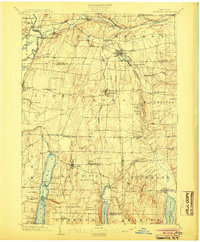
(6)- 1900 Map of Macedon
 1900 Macedon1900 Print · USGSMonroe and Wayne counties thrive at the intersection of water and rail transport at the end of the nineteenth century. Genealogists and historians can trace the original paths of the Erie Canal and locate long-standing settlements like Despatch, Fairport, and Webster.8 unique versions available
 - 1900 Map of Canandaigua, 1961 Print
 1900 Canandaigua1961 Print · USGSOntario County at the turn of the century shows a landscape defined by the steam-era commerce of the Finger Lakes. Genealogists can trace family connections to rural hubs like Baptist Hill, follow the Steamboat Route on Canandaigua Lake, or locate family farms near Thompson Cor and Mertensia.
 - 1901 Map of Honeoye, 1954 Print
 1901 Honeoye1954 Print · USGSThe Finger Lakes region at the turn of the century was a bustling corridor of milling and rail transit. Genealogists and rail historians can trace the intricate routes of the Lehigh Valley and Erie RR between settlements like Honeoye Falls and Richmond Mills.
 - 1903 Map of Canandaigua
 1903 Canandaigua1903 Print · USGSThe Finger Lakes region thrived at the dawn of the century, defined by a bustling network of railroads and steamboat traffic. Researchers can trace historic family landmarks at Baptist Hill, Mc Millen Corners, and lakefront points like Cottage City.7 unique versions available
 - 1904 Map of Caledonia
 1904 Caledonia1904 Print · USGSLivingston County and its surrounding borders are shown here at the height of the early railroad era. Researchers can trace the complex rail junctions at Caledonia or locate vanished landmarks and post offices like Wadsworth P.O. S.Greigsville and Retsof.6 unique versions available
 - 1904 Map of Honeoye
 1904 Honeoye1904 Print · USGSThe Finger Lakes region thrived at the start of the century as a vital rail and milling corridor. Researchers can trace the path of the Electric R. R. and locate family landmarks like Jakman Hill or the old milling sites at Richmond Mills.6 unique versions available
End of results
Showing maps 1-6 of 6
Top cities of Monroe County
- Rochester historical maps
- Greece historical maps
- Irondequoit historical maps
- Perinton historical maps
- Henrietta historical maps
- Webster historical maps
See more
Frequently asked questions
- What are the different types of historical maps available for Monroe County?
- What is the oldest map of Monroe County?
- Where can I purchase historical maps of Monroe County for my home or office?
- Where can I download high-res historical maps of Monroe County?
- Are there historical topographic maps available for Monroe County?
- Is there historical aerial imagery available for Monroe County?
- Where are historical maps of Monroe County sourced from?