1900s (20th Century) Maps of Monroe County, New York
Explore 93 historic maps of Monroe County from the 1900s (20th Century). These maps offer a rare glimpse into what life looked like during the 1900s — showing old roads, neighborhoods, homes, and landmarks that have changed or disappeared over time.
Whether you're researching your family's past, planning a metal detecting trip, or studying how Monroe County's landscape evolved across the 1900s, these high-resolution maps are a powerful tool for exploring the history of this region.
- Focus on a specific era: All maps on this page are from the 1900s, giving you a focused view of this time period.
- See what’s changed: Compare century-old streets, trails, and buildings to today's modern landscape using overlays and satellite layers.
- Research with precision: Use these maps for genealogy, historical research, land use analysis, or educational projects.
- View, download, or print: Maps are fully viewable online in high resolution, and can be downloaded or printed for your own records.
Start exploring Monroe County's history through authentic maps from the 1900s. This is your window into the past.
Monroe County, NY maps
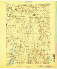
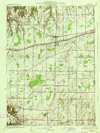
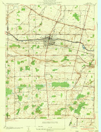
(93)- 1900 Map of Macedon
 1900 Macedon1900 Print · USGSMonroe and Wayne counties thrive at the intersection of water and rail transport at the end of the nineteenth century. Genealogists and historians can trace the original paths of the Erie Canal and locate long-standing settlements like Despatch, Fairport, and Webster.8 unique versions available
 - 1900 Map of Canandaigua, 1961 Print
 1900 Canandaigua1961 Print · USGSOntario County at the turn of the century shows a landscape defined by the steam-era commerce of the Finger Lakes. Genealogists can trace family connections to rural hubs like Baptist Hill, follow the Steamboat Route on Canandaigua Lake, or locate family farms near Thompson Cor and Mertensia.
 - 1901 Map of Honeoye, 1954 Print
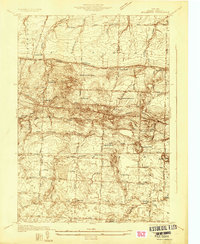
 1901 Honeoye1954 Print · USGSThe Finger Lakes region at the turn of the century was a bustling corridor of milling and rail transit. Genealogists and rail historians can trace the intricate routes of the Lehigh Valley and Erie RR between settlements like Honeoye Falls and Richmond Mills.
 - 1903 Map of Canandaigua
 1903 Canandaigua1903 Print · USGSThe Finger Lakes region thrived at the dawn of the century, defined by a bustling network of railroads and steamboat traffic. Researchers can trace historic family landmarks at Baptist Hill, Mc Millen Corners, and lakefront points like Cottage City.7 unique versions available
 - 1904 Map of Caledonia
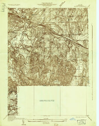
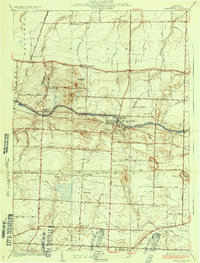
 1904 Caledonia1904 Print · USGSLivingston County and its surrounding borders are shown here at the height of the early railroad era. Researchers can trace the complex rail junctions at Caledonia or locate vanished landmarks and post offices like Wadsworth P.O. S.Greigsville and Retsof.6 unique versions available
 - 1904 Map of Honeoye
 1904 Honeoye1904 Print · USGSThe Finger Lakes region thrived at the start of the century as a vital rail and milling corridor. Researchers can trace the path of the Electric R. R. and locate family landmarks like Jakman Hill or the old milling sites at Richmond Mills.6 unique versions available
 - 1912 Map of Rochester
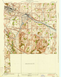
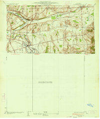
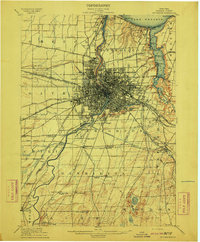 1912 Rochester1912 Print · USGSRochester and its surrounding Monroe County townships are shown here during a transformative era of canal and rail expansion. Genealogists can locate family-named stations and settlements like Maplewood Bealsburg PO, Mortimer, and Barnard along the busy tracks of the Lehigh Valley R. R.2 unique versions available
 - 1912 Map of Ontario Beach
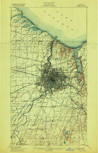
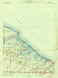
 1912 Ontario Beach1912 Print · USGSThe Lake Ontario shoreline near Rochester was a burgeoning hub of transit and tourism in the early twentieth century. Researchers can trace the path of the Grand View Beach Electric RR or locate landmarks like Genesee L. H. and Manitou Beach.
 - 1920 Map of Rochester
 1920 Rochester1920 Print · USGSRochester and its surrounding townships thrive at the height of the rail and canal era during the early 1920s. Researchers can trace the original routes of the Barge Canal and locate specific sites like the State Industrial School or South Greece Station.5 unique versions available
 - 1931 Map of Mendon Ponds
 1931 Mendon Ponds1931 Print · USGSMonroe County was undergoing a significant transition in the early 1930s as Rochester's industrial reach met rural township life. Genealogists can trace family footprints across dozens of district schools like Henrietta No 2 Sch or locate the Iola Sanitarium.
 - 1931 Map of Rochester West
 1931 Rochester West1931 Print · USGSMonroe County is seen here during the early thirties as the western suburbs of Rochester began to take shape alongside major transit corridors. Researchers can trace the path of the Erie Barge Canal and locate historic sites like St Bernards Seminary and Coldwater Sta.
 - 1931 Map of Rochester East
 1931 Rochester East1931 Print · USGSMonroe County was undergoing a period of rapid residential expansion in the early thirties as the city reached toward the lake. Researchers can find old neighborhood landmarks like the Genesee Lighthouse, Claverhouse PO, and the Riverside Cemetery.
 - 1932 Map of Webster
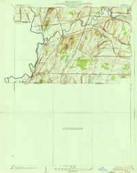
 1932 Webster1932 Print · USGSMonroe County settlements and rural school districts are captured here in the early 1930s. Genealogists can locate specific farm-to-market routes and historic landmarks like Thousand Acre Swamp, West Webster, and the New York Central RR.
 - 1932 Map of Hamlin
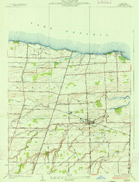
 1932 Hamlin1932 Print · USGSLake Ontario’s shoreline meets the orchards and rail-linked villages of northern Monroe County in the early 1930s. Trace old family plots at Lakeside Cem or follow the New York Central through Hamlin Station and Morton.
 - 1932 Map of Spencerport
 1932 Spencerport1932 Print · USGSMonroe County was a thriving network of canal-side hamlets and agricultural enterprise in the early 1930s. Genealogists and historians can trace family locations through numbered school districts and landmarks like Chesbro Seminary, the Harris Seed Farm, and Ogden Center.
 - 1932 Map of Fairport
 1932 Fairport1932 Print · USGSMonroe County's canal and rail corridor is captured here in the early 1930s, showing the vital intersection of the Barge Canal and major rail lines. Genealogists can locate family-named roads and numerous rural schools like School No 5 near Egypt.
 - 1934 Map of Rush
 1934 Rush1934 Print · USGSThe Genesee River valley in the 1930s serves as a busy crossroads for major rail lines and rural hamlets. Researchers can trace family homesteads along Martin Road, locate the grounds of School No 6, or map the rail junctions at Golah and West Rush.2 unique versions available
 - 1934 Map of Fairport
 1934 Fairport1934 Print · USGSMonroe County was undergoing significant planning and growth in the early thirties as the canal and rail lines shaped the Rochester suburbs. Trace the locations of historic rural schoolhouses, the Bushnell Basin Guard Gate, and the South Perinton Ch.
 - 1934 Map of Ninemile Point
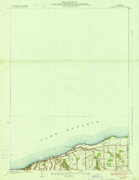 1934 Ninemile Point1934 Print · USGSCoastal Monroe County is captured here in the early thirties as the township of Webster developed along the lake. Genealogists and local researchers can locate Union Cem, School No 9, and old family routes like Salt Road.2 unique versions available
 - 1934 Map of Webster
 1934 Webster1934 Print · USGSMonroe County was a landscape of thriving orchards and rural school districts in the early thirties. Genealogists can locate family homesteads near Thousand Acre Swamp or trace the origins of West Webster and Penfield along the Ridge Road State Highway.3 unique versions available
 - 1934 Map of Braddock Heights
 1934 Braddock Heights1934 Print · USGSThe Lake Ontario shoreline in Monroe County appears in the mid-1930s as a series of lagoons and emerging beach communities. Genealogists and local historians can trace the foundations of North Greece and lakeside hubs like Braddock Heights or Manitou Beach.3 unique versions available
 - 1934 Map of Honeoye Falls
 1934 Honeoye Falls1934 Print · USGSMonroe County and the surrounding valleys are shown here in the 1930s, centered on the village of Honeoye Falls. Local historians can trace early school districts and family plots at Quaker Cem, Graves Cem, and the old rail hub at Rochester Junction.
 - 1934 Map of Spencerport
 1934 Spencerport1934 Print · USGSMonroe County was defined by its waterways and rural school districts in the mid-1930s. Genealogists and local historians can trace family lands near Adams Basin, locate the Chesbro Seminary, and follow the path of the New York State Barge Canal.2 unique versions available
 - 1934 Map of Brockport
 1934 Brockport1934 Print · USGSBrockport and the surrounding Monroe County countryside are captured in the mid-1930s as a thriving hub of canal and rail transport. Genealogists and local historians can trace the school districts, find rural cemeteries like Lake View Cemetery, and locate vanished landmarks along the Barge Canal.
 - 1934 Map of Hilton
 1934 Hilton1934 Print · USGSThe Lake Ontario shoreline in the 1930s reveals a vibrant mix of lakeside retreats and well-established farming districts. Researchers can trace ancestral property near Parma Center, find local schoolhouses like North Star Sch, or explore the early layout of Hilton.2 unique versions available
Showing maps 1-25 of 93
Top cities of Monroe County
- Rochester historical maps
- Greece historical maps
- Irondequoit historical maps
- Perinton historical maps
- Henrietta historical maps
- Webster historical maps
See more
Frequently asked questions
- What are the different types of historical maps available for Monroe County?
- What is the oldest map of Monroe County?
- Where can I purchase historical maps of Monroe County for my home or office?
- Where can I download high-res historical maps of Monroe County?
- Are there historical topographic maps available for Monroe County?
- Is there historical aerial imagery available for Monroe County?
- Where are historical maps of Monroe County sourced from?